
|
|
|
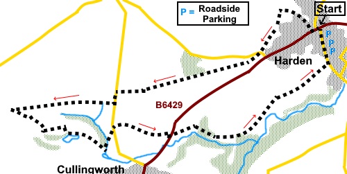
To view route as a dynamic Ordnance Survey map click here. Introduction: This walk shares a little of the route with my Cullingworth Circuit and is a walk over similar terrain. The walk is easy but there is potential for mud in a few places after heavy rain so gaiters might be handy! The route starts skirting the environs of Harden but meanders through pleasant countryside and offers good views south towards Denholme and along a pretty valley where Cow House Beck flows. An interesting landmark is the old chimney which served the furnace which powered the steam engines at Goit Stock Mill, a cotton spinning mill, one of six mills in the area. The chimney was built high up to avoid smoke building up in the valley and you can still see the remains of the flue which connected it to the mill below. It closed in the 1860s and became a café and ballroom, until destroyed by fire in 1927. I have to say its structure looks decidedly unsound and how much longer it will stand is debatable! Part of the route follows the Senior Way, a circular route, named after a Ron Senior, who got the walk signposted and recognised. The walk starts from the mini roundabout at the junction of Wilsden Road and the B6429 (Long Lane or Harden Road depending on which way you approach). Parking is on street, preferably not on the B6429, which gets congested enough as it is. I parked on Wilsden Road. Best to consult a map/Google as to the best way to get there, as this depends on where you are coming from. Start: From Wilsden Road turn left along the B6429, at the mini roundabout, passing St. Saviour’s church. Cross the zebra crossing. A hundred yards or so from the junction, opposite the school, turn right along an unnamed road and continue past the bollards to the end of the close and take the narrow walled footpath indicated by the footpath sign. Join a broad track and turn left (to the right of a house on the left). After passing the house, turn left over a stile and walk straight ahead to another stile which is visible.
Cross this stile and head for the left, diagonally opposite corner and over another stile. Cross straight over the lane (SE 082384) and over a barely recognisable stile and follow the left hand boundary of that field and the next. Cross a stream and again, keep to the left side of the field. About half way along this field, turn left along a walled/fenced path. At the road (SE 080381), turn right for a few yards, then left through a walkers’ gate signposted with a public footpath fingerpost and another for the “Senior Way”.
At the end of the small wood, cross a high stone stile and follow the left hand boundary of the field beyond. There are good views here across the valley. Pass what could be an old small quarry or crag at Hunter Hill (SE 073378).
Continue following the obvious path, crossing another high stile, until you reach the road. Turn left along it but take care as it is a straight, fast section, although there is a verge. After about a hundred yards, turn right, off the road, following a public footpath fingerpost and sign for the “Senior Way” along a walled footpath. The walled footpath leads into a field. Follow its right hand boundary. Then path goes through a small copse of trees and arrives at a row of terraced cottages. Follow the drive past them and at the tarmac lane, turn left. Follow the lane past Sugden House farm where, after going through a gate, the footpath curves right then left. It is defined by newly planted trees. Follow the path down and go through a five bar gate to continue along a walled track to the left of a pond. Ignore the path off to the right at this point.
Stay on the track, ignoring a path to the right just after the pond and crossing the drive to Lakeside Farm. Go over the railway bridge (SE 062373), staying on the track as it turns right. Arrive at the drive to Sunny Garth and turn right along it. Ignore a bridleway off to the right. Follow the drive down and you will reach a house which looks precariously perched on a crag. Turn left here, following a yellow footpath arrow (SE 064371).
Follow this narrow footpath to the road and cross straight over through a walkers’ gate. Follow the right hand boundary, until you go through a gate. Beyond that is a dilapidated wall. Follow this until you reach the gap where there clearly once was a gateway. Go through this and head for the gate directly ahead. Through the gate, follow the enclosed track to the houses, then take the road to the B6429. Cross straight across to follow the public footpath fingerpost, over a stile. Follow the obvious path which runs along the top of the pretty little valley, along which flows Cow House Beck.
Pass along a section of permissive footpath, then go left over a stile (SE 078372). The path curved round to the right. You will soon catch sight of the old chimney which served the furnace powering Goit Stock Mill. The path passes to its right and past a caravan (park homes) site.
Past the caravan site, look out for a turn off on to a footpath on the right hand side. Follow this obvious path to a farm then its broad drive. This drive leads to Wilsden Road where you turn left to where you parked. If you need to buy any hiking equipment/clothing before your trip see the Hiking Store All information on this site is given in good faith and no liability is accepted in respect of any damage, loss or injury which might result from acting on it.
| | |||||||||||||||||

.jpg)
.jpg)
.jpg)
%20Footpath%20out%20of%20Harden.jpg)
%20View%20towards%20Denholme%20from%20Hunter%20Hill.jpg)
%20Countryside%20view%20near%20Harden.jpg)
%20Rock%20outcrop%20on%20Hunter%20Hill.jpg)
%20Countryside%20View.jpg)
%20Fishing%20Lake%20after%20Sugden%20House%20Farm.jpg)
%20Local%20native%20at%20the%20fishing%20lake.jpg)
%20Precarious%20looking%20house%20above%20Ellar%20Carr%20beck.jpg)
%20Weather%20eroded%20rock%20near%20Ellar%20Carr%20Beck.jpg)
%20Along%20the%20valley%20of%20Cow%20House%20Beck.jpg)
%20Goit%20Stock%20Mill%20Chimney.jpg)