
|
|
|
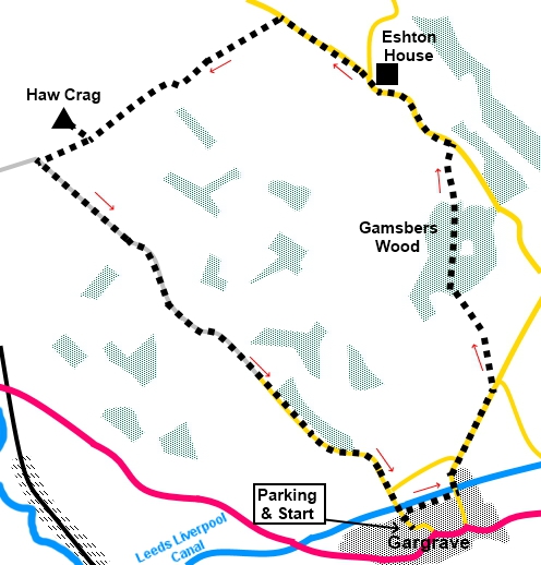
To view route as a dynamic Ordnance Survey map click here. Introduction: When asked by friends to accompany them on a walk to Haw Crag, near Gargrave, my first action was to dig out the OS map to find out where it was as I had not heard of it. Sitting about one and three quarter miles North West of Gargrave as the crow flies, it rises to a mere 676ft (206 m) and did not fill me with enthusiasm. However, I was wrong, as the views from its summit are remarkable considering the minimal effort required to get there. Haw Crag is a limestone outcrop, sporting a trig. point, overlooking the remains of an old quarry. It is a Site of Special Scientific Interest (SSSI) by reason of its geology. The explanations are too complicated for me but essentially it is a carboniferous reef dating from over 300 million years ago, with an unusual rock structure. Because of its prominence in that particular area of landscape, there is a clear 360° panorama taking in Sharp Haw, Weets Top, Great Whernside, Pendle Hill and Pinhaw Beacon to name but a few. There is about three quarters of a mile section of road walking, with no footpath and although there was some traffic, it was not a major problem. The views north are lovely even here. The walk starts from a free car park in Gargrave. To get to it, turn off the A65 at the Old Swan Inn on to North Street. The car park is a hundred yards or so on the right hand side. Start: Exit the car park and turn right to follow the fingerpost for the “Leeds Liverpool Canal”. At the canal, turn right and follow the towpath.
On reaching the road (SD 934545), by the locks, turn left for a third of a mile and turn left over a stone step stile, just before the National speed limit signs, at a fingerpost for “Eshton” (SD 936550) and head uphill towards Gamsbers Wood, crossing an old metal step stile of a somewhat unusual design, at the top of the first field. [28 March 2025 - it has been reported that the fingerpost referred to above is currently missing. As it leads off the road I would expect it to get replaced quicker than more remote ones but who knows? If you are doing this walk and find it has been replaced, please let me know so I can update for the benefit of others] Go through a metal kissing gate into the woods and follow the obvious path. At the far side of the woods, exit via another kissing gate and bear left at about 45° to cross a wooden stile and continue to the opposite corner of the field. Cross another stile and bear left to the road. Turn left along the road for three quarters of a mile (SD 934563).
Pass the turn to Winterburn Stay on the road until you get to Throstle Nest Farm, then turn off the road, following the fingerpost for “Mark House Lane 1 mile” (SD 925570) Shortly after crossing a cattle grid, bear left over a stile following a public footpath fingerpost. Follow the wall on the left to a ladder stile. Cross a rough track cross another ladder stile (or go through the walkers’ gate). Walk anti-clockwise around the copse of trees and through a walkers’ gate into a large field. As you get to the high point of the field, you will see Haw Crag with its trig. point. Keep well to the left of this to go over a gated stone step stile. The path follows the fence downhill but the short diversion to visit the trig. point and admire the view is a must (SD 914565).
Follow the fence downhill and go through a farm gate to a junction of broad tracks. Turn left.
Follow this track which eventually becomes a tarmac lane. At the ‘T’ junction, turn right to return to the centre of Gargrave.
If you need to buy any hiking equipment/clothing before your trip see the Hiking Store All information on this site is given in good faith and no liability is accepted in respect of any damage, loss or injury which might result from acting on it.
| | |||||||||||||||||

.jpg)
.jpg)
.jpg)
%20Boat%20about%20to%20leave%20locks.jpg)
%20View%20NW%20from%20the%20road.jpg)
%20Haw%20Crag%20Trig%20Point.jpg)
%20View%20West%20from%20Haw%20Crag.jpg)
%20View%20NW%20from%20Haw%20Crag.jpg)
%20Looking%20down%20into%20the%20old%20quarry.jpg)
%20Looking%20back%20at%20Haw%20Crag.jpg)
%20Sharp%20Haw%20and%20Rough%20Haw.jpg)