
|
|
|
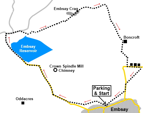
To view route as a dynamic Ordnance Survey map click here. Introduction: Embsay Crag is a gritstone outcrop to the north of the village of Embsay, overlooking Airedale and Skipton. There are fine views from the top overlooking Embsay Reservoir, to Skipton and Addingham Moors and more distant views to Pendle Hill, Beamsley Beacon and Simon’s Seat. This short walk takes you via Embsay Reservoir, it a short circuit, via the edge of Eastby. Embsay Reservoir was completed in 1909, the land having been compulsorily purchased from the Duke of Devonshire who owns Barden Moor above it. It was constructed to serve the growing population of Skipton. Stone was used from Embsay Crag. It is popular for sailing and fly fishing. The chimney you can see to the right as you approach the reservoir is around 120 feet high and belongs to the Crown Spindle Works. Built about 1820, it originally made metal spindles and consisted of a mill, a shed and two dams. Its subsequent use was packing cotton and tobacco, and during the First World War it made shell cases. It was converted to a private house in 1975. Its original 42t feet high, cast iron original waterwheel is still believed to be in situ. As you descend from the crag, you will pass Milking Hill Wood. This is a remnant of an ancient woodland, important for local wildlife. It was supplemented by additional planting in 1998, of Sessile Oak, Ash and Hazel. The
walk stats from the free car park in Embsay. To get there, turn south off
the A65 on to the A6131 at Skipton. The next on the right takes you into
Embsay village. Continue up the main street and the parking is just past the
Elm Tree Inn. Start: Just inside the car park entrance is a public footpath fingerpost pointing to “Pasture Road ¼ mile” and “Eastby Road ¼ mile”. Follow its direction through a kissing gate at the rear of the car park (SE 010538). Once through the gate, head for the top left hand corner of the field. Here, cross a gated step stile and follow the obvious path continuing in the same direction.
Go through a walkers’ gate and follow the direction of the public footpath fingerpost along the left hand side of the field. Go over a stile at the end of the field and immediately right over a stone step stile, and then bear slightly left in the direction of a public footpath fingerpost, crossing a broad farm track. Cross another stone step stile where there is a three way fingerpost and keep straight ahead. Over another step stile, keep straight ahead until you meet the road (SE 004539), opposite the village pond and turn right along the road. It is a dead end road so there should be little traffic.
As you walk along the road, note the Crown Spindle Works chimney over to the right.
Continue past the reservoir following a fingerpost for” Embsay Crag 1 mile” and “Embsay Kirk 2 miles”. As you start to climb, you get views over Skipton and to Pendle Hill.
Stay on what becomes a stony track until about three hundred yards past the end of the reservoir it bends sharply left (SD 996548). At this point, turn right over a stile following a public bridleway fingerpost for Embsay Kirk and Embsay Crag. There is an information board about Access Areas on Barden Fell. Ignore the path signed for Crookrise Crag and keep straight ahead. As you come to a stone building at the edge of the reservoir, there is a two way fingerpost. Branch off right along by the wall. Cross a footbridge and stay on the obvious track as it starts to climb the hill. The route is marked occasionally by blue topped posts indicating a bridleway.
As you get to a large rock, the incline steepens. Avoid a path just before this which heads left up a small valley. Keep climbing to the top of the crag which is unmistakable. On the small plateau at the top of the crag, the main path bearing slightly left and descending is obvious. Follow this and when the path forks, take the right fork. (SE 005551).
Follow the path downhill, ignoring any turns off, until you reach a gate (SE 010552). Through this, follow the direction of the fingerpost to Eastby, alongside the wall.
The path joins a green lane by Milking Hill Wood. Follow this lane downhill to a farm. Keep to the right of the farm and follow its access track down to the road (SE 012544). Turn left briefly, for a couple of hundred yards, then turn right, just before the village sign for Eastby, turn right following the public footpath fingerpost for “St Mary’s Church”.
Arrive at the church and turn left along the road for about a hundred and fifty yards. Turn right by the house “Greenside” following a public footpath fingerpost (SE 012540). Head for the diagonally opposite corner of the field and continue beyond the stile there along the enclosed footpath to arrive back at the car park. If you need to buy any hiking equipment/clothing before your trip see the Hiking Store All information on this site is given in good faith and no liability is accepted in respect of any damage, loss or injury which might result from acting on it.
| | |||||||||||||||||

.jpg)
.jpg)
.jpg)
%20Embsay%20Crag.jpg)
%20Embsay%20Mill%20Pond.jpg)
%20Crookrise%20Crag.jpg)
%20Crown%20Spindle%20Mill%20Chimney.jpg)
%20Boats%20by%20Embsay%20Reservoir.jpg)
%20View%20over%20Embsay%20Reservoir.jpg)
%20View%20to%20Addingham%20and%20Ilkley%20Moors.jpg)
%20Rocky%20outcrop%20on%20Embsay%20Moor.jpg)
%20Autumn%20Colours%20at%20Eastby%20Crag.jpg)
%20St.%20Marys%20Church%20Embsay.jpg)