
|
|
|
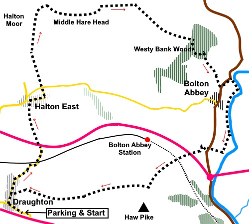
To view route as a dynamic Ordnance Survey map click here. Introduction: This walk combines a lovely country walk with a ‘surprise’ view at Halton Edge over what is shown on the OS map as Barden Broad Park stretching to Barden Moor and Simon’s Seat. The turning point of the walk is a stroll by the river Wharfe at Bolton Abbey and a chance to inspect the ruined priory. It was a very peaceful walk and I only saw three people apart from at Bolton Abbey itself. In the process, you pass through Draughton and Halton East, both attractive places. Draughton is one of those ‘mystery’ places that few visit because it lies off the main A65/ A59 roads, along which the hoards rush on their way to and from the Yorkshire Dales and Lake District areas. Indeed, if you arrive in Draughton, that is probably where you are going, as there is no other reason to visit. Even as a relatively local person, I have probably only ever been there a couple of times. It is a beautiful village, with some lovely properties, very tranquil and with no facilities (pubs, shops etc), probably another reason it is not on most people’s itinerary. It has a number of listed properties/features. The name Draughton is believed to originate from the Anglo Saxon word draeg (draw or drag) indicating where loads have to be dragged up or down steep hills. It was primarily an agricultural village with home wool combing in the later 18th century. It was once connected to the railway system but the link was lost in the 1960s. Halton
East is smaller. Its name
derives from the Old English halh (meaning
nook) and tun (meaning farm or village). It has East added to
distinguish it from Halton West in Ribblesdale. It too has a number of
attractive buildings. Finally we come to Bolton Abbey which needs little introduction. This was an Augustinian monastery which met its end, like so many others, at the hands of Henry VII in 1539. It forms part of the Duke of Devonshire’s estate. The area around the ruined monastery is very well kept and very popular with visitors. There is a pleasant walk through the woods there to see the famous Strid but I did not go there on this occasion. There is more information on my Bolton Bridge to Barden Bridge and The Strid walk and much on line about the monastery. The walk starts from a lay-by, on the left, just after taking the eastern turn off into Draughton off the A65, between Skipton and Addingham. There looks to be plenty of on street parking in the village but I preferred not to clutter the place! I do not advise approaching from the A59 as the road is very narrow and if you meet much coming the other way, there will be some reversing! Start: Walk into the village from the lay-by (SE 041522), continuing along the road and going right at the first junction. Continue through the village and beyond until you reach the A59. This is a fast, busy road. Cross with car and take the footpath indicated by the finger post for “Halton East ½ mile”. You want the path straight ahead, not the one parallel with the main road.
Walk up the field, keeping well to the right of the barn to a step stile over the wall. This becomes visible as you get further up the field.
Cross the stile and head for the farm. The path runs through the farm to the left of the barns, through two metal gates, along a short walled section. Go through to the road and turn right. Follow the road through the village, as it bends left and at the ‘T’ junction, follow the public footpath straight ahead indicated by the fingerpost for “Broad Park 1¼ miles”.
Follow the left hand boundary to the top of the field. Cross the stile (SE 043547) and head for the diagonally opposite corner of the field. Cross a stile and follow the right hand boundary to cross a ladder stile and again, follow the right boundary. As you crest the hill, you see the impressive ‘surprise view’.
Turn right, along the right fork, following the wall on the right. Go
through a gate in the wall (SE 044555) and follow the obvious route. This
bridleway curves left in an arc but it was obvious most people cut the
corner, to the summit at Middle Hare Head (SE 050553). Continue
ahead, to meet a wall and turn left to follow it to a gate (SE 059555). Once
through here, the well trod path cuts the corner of the official route and I
must confess to doing the same, passing some large concrete structures
(water sources?), which provided a great lunch stop with good views. Continue in the same line, until you reach a gate. Through this, go left following the public bridleway fingerpost. The route becomes marked with large rocks bearing prominent blue markings. Go through a gate into Westy Bank Wood (SE 068549). Follow the obvious path as it bears right, ignoring the left path. As you come out of the trees, head for the left hand corner of the field and go through the left of the two gates. Follow the edge of the trees to the far left hand corner of the field and through the gate. Turn left heading for the castellated building (Bolton Hall).
Turn left at the road for less than two hundred yards, then right into the Bolton Abbey grounds following the finger post for Bolton Bridge and Storiths and passing through the graveyard.
Explore at will then follow the river south (i.e. it needs to be on your left). After about three quarters of a mile, look out for the Devonshire Arms on the right. Pass though its car park and turn left for a few yards to the bus turning space. At the rear of this, go through the gate (indicated with a fingerpost) (SE 070532). After only about seventy five yards, take the public footpath on the left. Follow this path through to the A59 and after crossing with great care, climb the steps at the far side. On emerging into the field, turn right and follow the track parallel with the wall. After going through a gate (SE 061526), continue in the same direction to another gate. At the end of the field, go through another gate marked with a blue bridleway arrow and follow the wall on the left. The route is then slightly left, in the direction of the stone house ahead. You should see a fence line and the route goes round the right hand corner of it, to drop down to a gate. Beyond that, follow the left hand field boundary. Join a broad tarmac track and turn right along it until you reach another track. Turn left and follow this into Draughton. Turn left to retrace your steps to the parking. If you need to buy any hiking equipment/clothing before your trip see the Hiking Store All information on this site is given in good faith and no liability is accepted in respect of any damage, loss or injury which might result from acting on it.
| | |||||||||||||||||

.jpg)
.jpg)
.jpg)
%20View%20down%20Draughton%20Main%20Street.jpg)
%20Looking%20to%20Embsay%20Crag.jpg)
%20View%20towards%20Skipton%20Moor.jpg)
%20Remains%20of%20the%20hill%20at%20Skipton%20Rock%20Quarry.jpg)
%20View%20near%20Halton%20East.jpg)
%20Another%20view%20near%20Halton%20East.jpg)
%20View%20at%20Halton%20Edge.jpg)
%20Looking%20Towards%20Simon's%20Seat.jpg)
%20Approaching%20Bolton%20Abbey%20Hall.jpg)
%20Bolton%20Abbey.jpg)
%20Bolton%20Abbey.jpg)
%20Bolton%20Abbey.jpg)