|
Bolton
Bridge To Barden Bridge and The Strid
Starting point and OS Grid reference:

Free
car park at Bolton Bridge (SE071530)
|
Ordnance Survey Map
OS
Explorer 297 – Lower Wharfedale & Washburn Valley or OL2 Yorkshire
Dales - Southern & Western.
Buy
these maps from
List
of OS Maps
Note: If you use OS Maps on-line, you can download this route via this
link.
| |
Distance: 8.4 miles
|
Date of Walk: 13 August
2014
| |
Ascent:
Descent:
See Walking Time Calculator
|
848ft (259m)
848ft (258m)
| |
Traffic
light rating: 
(For explanation see My
Walks page)
| |


For advice on .gpx files see
My Walks page
|

Click
the PDF logo above to give a printable version of this walk without the
photos.
|
To
view route as a dynamic Ordnance Survey map click here.
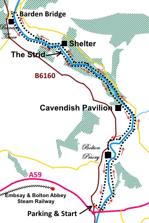
Introduction:
This walk takes you through part of
the Duke of Devonshire’s Bolton Abbey estate, following the course of the
River Wharfe. Some is on concessionary footpaths. The area is a tourist
honey-spot so unless you go out of season, you are likely to encounter
plenty of company. Having said that, it is a very pleasant woodland walk,
through one of the largest areas of acidic oak woodland in the Yorkshire
Dales. The walk travels some distance from the main car park areas and as
most punters are too lazy to walk far, much of the walk is still peaceful.
Some of this walk also follows part of the Dalesway.
One positive aspect of the walk being through
a tourist spot is that, in the main, the paths are well maintained and wide.
Although this makes the walking easy, it still needs to be treated with a
little respect. The outward leg has some very steep drops down towards the
river, which could cause you significant injuries, if you tumbled.
The walk takes you as far as Barden Bridge,
built in 1659. It is Grade II listed and a Scheduled Ancient Monument. From
the car park next to it, my Barden Bridge to Simons Seat walk starts.
The return leg takes you past the famous and
dramatic Strid. Here, the River Wharfe funnels into a narrow channel. When
you look at the width of the upstream section and realise how the water is
squeezed, it is obvious that the channel must be extremely deep. The
currents are fierce and legendary. Take great care. Rocks close to The Strid
can be very slippery. If you fall in, you will not see the light of day
until the divers fish out your corpse! Harsh but true.
The Bolton Abbey walk gives you an
opportunity to visit the ruined Priory.
There are various refreshment opportunities
en route, the most convenient being the well known Cavendish Pavilion. There
is a scattering of benches along the route for picnic stops and there is
also a large shelter on the outward journey, should the weather be inclement
– see sketch map for approximate position.
I started the walk from a tiny, free car
parking area just by the roundabout linking the A59 and the B6160. There is
only space for 6 or 7 cars. If this is full, and as the main “official”
Bolton Abbey car parking areas are fast approaching a double figures pound
cost in summer, the free alternatives are:
a) From the roundabout, take the B6160 south
towards Addingham. There is a rough lay-by a few hundred yards along the
road, on the left.
b) As this is a circular walk, you could
start from the car park at Barden Bridge.
I have provided a GPS route but this will be
of limited use due to the trees.
Start:
From the small car park (SE071530), continue along the lane away from
the B6160, through the double gates and cross the river. Turn left just
before the farm, following the fingerpost for “Priory and Footbridge”.
%20View%20to%20Simons%20Seat.jpg)
You barely need any further directions. It is
a case of following the clear footpath by, then above the river, at some
height in places. You pass above the Priory ruins with good views.
%20Bolton%20Abbey%20priory%20ruins.jpg)
%20View.jpg)
Eventually, at
SE 081550, the path meets a lane at a ford over which flows Pickles
Beck. If necessary, there is a footbridge to maintain dry feet. Once over
this, take the path across the road, fingerposted for Posforth Bridge (this
is not the wooden bridge you can see leading to the Cavendish Pavilion, but
a stone one you see further on). At the river, do not cross it but turn
right to follow the clear path.
%20Ford%20at%20Pickles%20Beck.jpg)
%20Cavendish%20Pavilion.jpg)
You reach a junction where the right hand
path is signposted for Simon’s Seat via the Valley of Desolation. Ignore
this and continue to follow the path by the river, climbing the stone steps.
Pass Posforth Bridge, a stone bridge carrying
the road over Sheepshaw Beck (SE 074559).
You pass high above The Strid and soon come
to a stone shelter with plenty of seating.
%20The%20Strid.jpg)
%20Shelter.jpg)
%20Rapids.jpg)
The next landmark is the aqueduct. A path
crosses this should you wish to shorten the walk (by about a mile).
Otherwise continue along the river to Barden Bridge (SE 052574). On the way
you will catch glances of the Barden Tower ruin across the river.
“Barden” means valley of the wild boar and this ruin was a hunting
lodge, built in the 16th century.
Cross Barden Bridge and go through the gate
on the left to follow the well manicured path.
%20Barden%20Bridge.jpg)
%20Acqueduct%20near%20Barden%20Scale.jpg)
You come to The Strid and are likely to hear
its roar before you see it. Please take great care here.
%20The%20Strid.jpg)
Come to a fork in the path where the left
fork goes to the Lud Stream Islands. Keep right.
Pass the Cavendish Pavilion and follow the
main path by the river until it climbs to join the road at the Cavendish
Memorial, built in honour of Lord
Frederick Charles Cavendish, son of the 7th Duke of Devonshire.
Turn left to follow the path by the road for a short distance before turning
left through a gate, to walk down to the Priory.
%20Cavendish%20Memorial.JPG)
%20Cows%20drinking.jpg)
%20The%20priory.jpg)
Descend
to the river once more to follow it past the stepping stones and bridge.
There is no need to cross the river but please be careful if attracted to
trying out the stepping stones. There have been incidents here with people
being caught out by either the depth of water or sudden torrents.
%20Stepping%20stones%20at%20Bolton%20Abbey.jpg)
The
path follows the river back to the start point.
If you need to buy any
hiking equipment/clothing before your trip see the Hiking
Store
All information on this
site is given in good faith and no liability is accepted in respect of any
damage, loss or injury which might result from acting on it.
|


.jpg)
.jpg)
.jpg)