
|
|
|
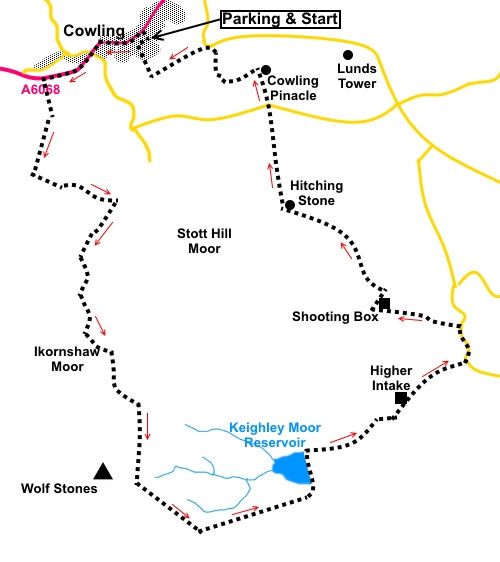
To view route as a dynamic Ordnance Survey map click here. Introduction: This walk from Cowling provides a circular walk over part of Keighley Moor, passing the Hitching Stone and Cowling (or Wainman’s) Pinnacle ( see Lund’s Tower and Cowling Pinacle walk for more information). The walk climbs to over 1300 ft (400 metres) which means fantastic vantage points with views to Pendle Hill, Emley Moor and over to Beamsley Beacon and the Yorkshire Dales. The area is typical heather moorland and judging from the number of shooting huts, is very popular for grouse shoots. On the plus side, I did this walk in August and the purple of the heather was wonderful. The Hitching Stone is supposed to be the largest rock in Yorkshire weighing in at over 1000 tonnes. They must have had big scales! Certainly, it is massive. Like so many large boulders, there is the almost obligatory legend of the person (usually a giant but in this case a witch) who threw it from its original position to where it is now. On
its western face is a rectangular cavity, probably a manmade enlargement of
something original, which forms the Druid’s or Priest’s Chair, in which initiates supposedly sat to watch
the equinox setting of the sun over Pendle Hill. This “tying” of the sun
to Pendle Hill may be the origin of the term “Hitching Stone”. At the
back of the chamber is a tube right through the rock said to have been left
behind by the decaying of a fossilised tree and which emits a hum when the
wind is in the right direction. No tunes when I visited! On
the very top of the stone is a large cavity containing a pond said never to
dry, although I did not climb up to check. It was the starting point for horse-racing event until the end of the 19th century. It was the site of a Lammas fair until 1870. The list of interesting facts goes on and on. The Hitching Stone has enough stories around it to justify a website of its own and if you are interested enough, I suggest some “Googling”. Cowling where the walk starts is a typical former mill town with rows of stone terraced cottages, strung out along the A6068. The mills are now gone and it now mainly provides a dormitory village for workers in nearby towns. The elongated profile of the village along a very busy road does not provide attractive parking so I turned off south on to Walton Street. At the top of the street is the Methodist Church and there is quiet on street parking there, without being directly outside anyone’s front door. The walk directions start from there. To get to Cowling, take the A6068 between Colne and Cross Hills. It is about half way between the two. There are no refreshment stops during the walk but a stone kerb along the embankment edge of Keighley Reservoir dam makes for a handy picnic stop with a nice view. Start: Walk back down Walton Street (SD 975432) and turn left along the main street. There is an attractive view over Holy Trinity church as you approach the end of the village. Pass Gill Lane and continue along the main road past the national speed limit sign. Look out for a left turn “Public Footpath, Pennine Way, Lumb Lane ¼ mile”.
Climb the short walk to a walkers’ gate and in the field beyond, follow the left hand boundary.
As you get nearer the farm, the path breaks away right to a gate just to the left of the barn. Through this, follow the Pennine Way beyond, as it passes along an old, walled track.
After cresting the brow of a hill, keep straight ahead ignoring a right turn by a barn. Continue following Pennine Way signs, curving sharply left be a farm gate, after passing a small waterfall. Follow yellow Pennine Way markers, going through a gate on to rough pasture. The route is fairly obvious but if in doubt, head for a ruined building on the hilltop ahead and passing over a footbridge. There a large number of shooting lodges on this stretch. Views to Pendle Hill appear.
After the last shooting lodge, a substantial stone structure, there is a section of footpath across the heather moorland, “manicured” with stone slabs, which makes it easy to follow.
As you progress, to the right, the trig. point at Little Wolf Stones appears and ahead, across the valley is Stanbury Moor, where the famous ruins of Top Withens are situated (see Haworth to Bronte Waterfalls and Top Withens walk).
Continue to follow the obvious Pennine Way path. At SD 979389, the path reaches the end of a long stone wall, where there is a marker post indicating the path beyond is the Millennium Way. Turn off left here on a clear path (known as Fairy Fold Dyke I am told) towards Keighley Moor Reservoir, just visible in a hollow. When the path forks (SD 985391), keep left towards the reservoir.
At the reservoir, turn left across the dam and right at its end after, going over the bridge. Follow the access track from the dam, passing Higher Intake Farm until you reach the road and turn left along it (SE 002404). Pass Slitheroford Farm and stay on the road as far as Middle Slippery Ford Barn, turn left following a public footpath fingerpost, effectively turning back on yourself briefly. Follow the walled track until you go through a gate and continue to follow it, across more open pasture. Through a second gate just before a farmhouse (now a shooting lodge) and you enter Access Land. Turn right at the furthest corner of the farmhouse, leaving the OS marked public footpath and follow the wall on the right for about two hundred yards as far as another wall, with a gate. Ignore the gate and instead turn left here to follow this second wall.
The path is now narrow but just visible amongst the heather. Continue to follow this wall, including where it bends right. However, when it becomes supplemented by a parallel fence, keep to the left of the fence otherwise you will have a very tricky precipice to negotiate! There are good views here of the ridge which is home to Lund’s Tower and Cowling Pinacle. At SD 987417, you arrive at the unmistakable Hitching Stone. Walk clockwise round it and follow the wall on the right downhill.
At the road, go straight ahead, and join the ridge (Earl Crag), at Cowling Pinnacle.
Turn left here to follow the ridge west for less than a quarter of a mile. Take a descending track on the right (SD 981428) and follow it as it zig-zags down the hill. At a ‘T’ junction of paths turn left (SD 982429) and a little further on, turn right. At a small crossroads of paths, turn left. You are heading for the road visible below and the farm on the corner Baywood House. Walk along the track to Baywood House and at the farmhouse door turn right to a stile. Once over this, follow the right hand boundary of the field. There were and probably mostly are horses in this field but they ignored us. At the end of the field is a narrow slit stile. Over this, head for the gate opposite and go along the walled track. At the lane by Fold Farm Cottage, turn right. Take the first road on the right and the Methodist church comes into view.
If you need to buy any hiking equipment/clothing before your trip see the Hiking Store All information on this site is given in good faith and no liability is accepted in respect of any damage, loss or injury which might result from acting on it.
| | |||||||||||||||

.jpg)
.jpg)
.jpg)
%20View%20to%20Holy%20Trinity%20church.jpg)
%20Cowling%20Pinacle.jpg)
%20View%20back%20to%20Cowling.jpg)
%20View%20to%20Sutton%20Moor.jpg)
%20Shooting%20lodge%20with%20Pendle%20Hill.jpg)
%20Substantial%20shooting%20lodge.jpg)
%20Telephoto%20shot%20of%20Pendle%20Hill.jpg)
%20View%20to%20Stanbury%20Moor.jpg)
%20Keighley%20Moor%20Reservoir.jpg)
%20Shooting%20box%20after%20turning%20right.jpg)
%20The%20Hitching%20Stone.jpg)
%20Druids%20chair.jpg)
%20Cowling%20Pinacle.jpg)
%20View%20from%20Earl%20Crag.jpg)