|
Lanzarote
Walk - Montaña Los Rodeos
|
Starting
point:
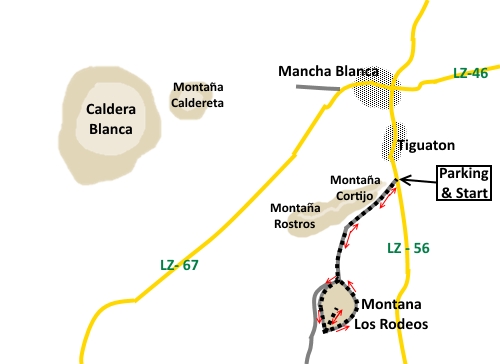
Parking
area just outside Mancha Blanca village
|
Map
I
have found this to be the best map for both walking routes and driving, from
Discovery Walking Guides Ltd
Lanzarote
Tour and Trail Map 1:40,000 scale

| |
Distance:
4.4
miles
| |
Traffic light rating:


or
if you omit the summit
(For explanation see My
Walks page)
More great Lanzarote
Walks
|

Click
the PDF logo above to give a printable version of this walk without the
photos.
|
Introduction:
This is mostly a very easy walk to Montaña Los Rodeos because it follows a broad level track, across a sea of lava. I suspect it is
used for 4x4 tours, although I saw no such vehicles when I did the walk. The
hard work comes if you decide to complete the walk to the summit, which
involves a steep walk of about 1/3 of a mile up a
slithery path. Actually this is more of a problem on the descent, when your
feet slide a little but there
are no steep drops to worry about and it is worth the trip.
The walk is very interesting for several
reasons. On the outward journey, there is a tremendous view west to the
Montañas del Fuego de Tymanfaya and there is one volcano in particular
where you can clearly see where the side of the crater collapsed, allowing a
sea of lava to gush forth. The flow of the lava is clearly visible, across
the land.
Montaña
Los Rodeos itself is a mountain of orange rock covered with a grey/black
ash. In places, the ash has been eroded allowing the colour beneath to show
through and nowhere is this more apparent than on the steep ascent path to
the top. The views from the summit are fantastic, stretching as far as the
cliffs at Famara in the north. There are various volcanic cones around, not
least Montaña Cuervo to the south and
Caldera Blanca to the north-west.
Finally,
on the return leg, you can clearly see where the sea of lava to the east
flowed and the very edge of the “tide” comes alongside the track.
The walk starts from a large parking area
planted with palm trees by the LZ-56. There is a brown sign with white
lettering at the car park entrance for “Parque Natural de Los Volcanes”.
Start:
Walk south-west along the obvious broad track leading from the car park,
soon passing a part built (or part demolished – I could not decide which)
building against the hillside on the right.
%20Along%20the%20track%20and%20Montana%20Cortijo.jpg)
After
quite some distance, you arrive at the base of Montaña Los Rodeos at
effectively a ‘T’ junction. You can go either way round but I chose to
turn right to walk anti-clockwise around the base of the mountain.
Eventually,
you will pass some very large lumps of lava on the right closely followed by
a small car parking area. The track divides. Take the left hand fork. Here,
in the distance, to the right you can clearly see the volcanic cone which
has collapsed at one side and the flow of lava from it.
%20Collapsed%20crater%20and%20lava%20flow.jpg)
%20Montas%20Cortijo%20&%20Rostros.jpg)
%20Looking%20across%20the%20lava%20sea%20to%20its%20source.jpg)
You
arrive at a large turning area defined by placed boulders. There are good
views ahead of Montaña Cuervo. The route to the top of Montaña Los Rodeos
is obvious, as an orange/red track ascending an otherwise grey/black
mountain. You can either take this track (it really is worth it), or just
continue on the easy track round the base of the mountain.
%20View%20south%20from%20turning%20area.jpg)
%20The%20summit%20path.jpg)
%20View%20east%20from%20summit%20path.jpg)
%20View%20to%20cliffs%20of%20Famara.jpg)
%20Summit%20view%20of%20Approach%20track.jpg)
%20Montana%20Cuervo.jpg)
The
summit path begins fairly gently then becomes steeper after a “false
summit”.
The
summit is marked by some rather pathetic cairns but the views are amazing.
Return
to the main track by the turning area and turn left.
It is along this section that you can
clearly see where the sea of lava flowed and the edge of the “tide” is
alongside the track once you have descended a little.
%20Edge%20of%20the%20lava%20tide.jpg)
%20Edge%20of%20the%20lava%20tide%20by%20the%20track.jpg)
The track curves back to the ‘T’
junction where the circuit started. Turn right to retrace your steps to the
car park.
If you need to buy any
hiking equipment/clothing before your trip see the Hiking
Store
All information on this
site is given in good faith and no liability is accepted in respect of any
damage, loss or injury which might result from acting on it.
|


.jpg)
.jpg)
.jpg)