|
Wiswell
to Sabden
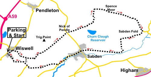
Starting point and OS Grid reference:

Pendleton
Road, Wiswell. Roadside parking (SD745374).
|
Ordnance Survey Map
OS
Explorer 287
West Pennine Moors.
Buy this map from
List
of OS Maps
Note: If you use OS Maps on-line, you can download this route via this
link.
| |
Distance: 10
Miles
|
Date of Walk: 27 February 2015
| |
Ascent:
Descent:
See Walking Time Calculator
|
1764ft (538m)
1766ft (538m)
| |
Traffic
light rating: 

(For explanation see
My Walks page)
| |


For advice on .gpx files see
My
Walks page
|

Click
the PDF logo above to give a printable version of this walk without the
photos.
|
To
view route as a dynamic Ordnance Survey map click here.
Introduction: This
walk from Wiswell (pronounced “Wizzle”) takes you over the 1462 ft high
Spence Moor and down into Sabden. Overall, it is an easy walk with a bit of
a steep, though short climb back up to Wiswell Moor near the end.
Wiswell
is so named, either from Old Molly’s Well, which became known as the wise
woman’s well or because there
was a local Saxon chief called Wisa, Wigga or Wysa and it had (and still
has) a well. The latter explanation sounds more credible to me. You will see
the well on the last stage of the walk.
It
is a very attractive upmarket village which has won best
kept village in the “Hamlet” class several times and proudly displays
its “trophy” plaques.
Sabden
was originally a farming, quarrying and handloom weaving town. Cotton mills
flourished, then the high quality of the water in the valley attracted the
calico printing industry. Sadly the industry died in the 1930s and most
other industry seems to have died since, leaving a typical ex-industrial
town with a somewhat melancholy look. However, the locals seem very friendly
and the town is surrounded by lovely countryside.
From
the top of Spence Moor are long distance views over Ribblesdale, and south
to Blackburn, Burnley etc – or at least there should be. On the day I did
this walk, low cloud rather impeded the views. Pendle Hill is next door, to
the north.
Ideal
picnic stops are a little in short supply, though there is a pleasant grassy
area (SD 802381) along the lane after Sabden Fold. There are also a couple
of pubs in Sabden.
The
walks starts from Wiswell. There is no specific parking area but Pendleton
Road in the centre of the village is amply wide enough for roadside parking.
As a common starting point, the walk starts from the pleasant village
“garden” area at the junction of Pendleton Road and Moor Lane. There is
a phone box and flag pole here and benches, handy for boot changing.
To
get to Wiswell, turn north-west off the A59 at a roundabout just outside
Clitheroe on to the A671. Left and left again over the A59 will take you
into the village.
Start: From
the phone box/flag pole (SD 745374),
walk up the hill (Pendleton Road) and turn right on to Moorside Lane (SD
747375) (not to be confused with Moor Lane mentioned above). Follow it to
its end and take the footpath marked with yellow arrows to the right of the
entrance to Wiswell Brook Farm.
Follow
the path climbing up the moor, under some power lines, towards the radio
mast.
%20Whalley%20Viaduct.jpg)
%20Panoramic%20view%20over%20Ribble%20Valley.jpg)
%20Approaching%20radio%20mast%20on%20Wiswell%20Moor.jpg)
Just
before the mast, go over the left hand of two stiles (one either side of a
wall) and follow the path left of the mast.
On
meeting the track to the mast, go straight across and follow the path as it
descends. When you meet the track to the farm, turn left then quickly right
through a walkers’ gate marked with a yellow arrow. Cross the narrow field
and through a second walkers gate then turn left, on a broad track (SD
757371). There is a large sign here which tells you this will take you to
The Nick of Pendle.
%20Descending%20from%20top%20of%20Wiswell%20Moor.jpg)
%20Direction%20Sign.jpg)
%20View%20to%20Spence%20Moor.jpg)
When
you reach the road, more or less opposite, are two broad tracks from the
road. Take the one on the right. Follow this briefly and as it curves left,
branch off to the right across the rough grass towards a lower broad path.
You should be heading more or less towards the reservoir (Churn Clough
Reservoir).
%20View%20over%20Sabden.jpg)
%20Churn%20Clough%20Reservoir.jpg)
Turn
left on the lower path (SD 776385). You will pass a three way fingerpost.
Continue in the direction of “Churn Clough” and “Crags”.
Go
through a kissing gate and take the path on the left.
As
you come level with the reservoir, there is a narrower path off left but
ignore this and stay on the main path.
The
path bends left by a stream. Stay on it and do not be tempted by the stile
into woodland.
Keep
following the obvious path and when you come to a kissing gate (SD 785394)
through a wall, do not go through
it but turn right to follow the wall on a concessionary footpath.
Follow
the wall until you reach another kissing gate. Follow the path from here on
to Spence Moor (SD 790394).
%20View%20from%20Spence%20Moor.jpg)
From
the top of the moor, the path descends gently to a ladder stile. Go over
this and continue in the same direction.
After
dropping down to a kissing gate, turn right and follow a series of ridges
and stream down to the corner of a wood (SD 805790). At first gland, it may
not be obvious there is a path here. Follow the left hand edge of the wood
(Cock Clough Plantation). Do not take any routes into the wood but follow
its edge down to the tarmac lane at Sabden Fold. Turn right here.
%20View%20at%20Cock%20Clough%20Plantation.jpg)
Follow
the lane to the entrance to Old House Farm and turn right (SD 807383).
Follow this old lane for half a mile and after passing some farm buildings,
go through a gate. The track starts to climb slightly and turn right. On the
corner, branch off to the left.
At
the property with a wind turbine, go through the walkers’ gate to the left
of the property. Follow the well marked path down through the fields,
arriving at a farm. The path goes to its left over a stone step stile. Then
go through a kissing gate on to the farm track. Turn left, passing a
historic farm at Dean (SD 789374) with stone mullion windows, dating from
the 1574. This is the oldest farm in the valley.
Continue
along this track, arriving in Sabden just a field away from St. Nicholas
Parish Church. Go straight ahead along St Nicholas Avenue. At the main road,
(Padiham Road) turn right then left on Whalley Road following the road sign
for “Whalley 3 miles”.
%20St%20Nicholas%20church%20Sabden.jpg)
Follow
the road for three quarters of a mile through Sabden. Pass the national
speed limit sign and the sign (if you were coming the opposite way) for
Sabden. Look out for a farm gate on the right (SD 768369), with an old stile
next to it (not easy to spot). Go through the gate and head across the
field, initially in the direction of the radio mast on the hill.
%20View%20back%20to%20Spence%20Moor.jpg)
The
path gradually curves slightly left, crossing a footbridge and goes to Lower
Barn Farm, passing to its right via a stile. Keep straight ahead, ignoring
the turn to the right.
Just
past the property, cross a stile and turn right to follow the stream.
You
lose sight of the radio mast for a while but keep plodding uphill and it
will appear again. At the top of a large steep field, go through the gate
and follow the right hand boundary of the next field. At a gate, turn right.
At
the tarmac lane (SD 754378), by the sign for Bramley Farm Cottages, turn
right and almost immediately left following the public footpath finger post.
The
path climbs steeply uphill alongside the wall to the brow. Ignor any turns
off.
At
the brow, with the radio mast on your right, go left through the gate, then
bear right following the white footpath arrow downhill, towards Wiswell. Go
through a farm gate then quickly through another on the right. Then follow
the left hand boundary of the field.
At
the entrance to Sheep Cote Farm, join the road and turn right back to the
phone box/flag pole in Wiswell. On the way, watch out for the ancient well
on the right. This was recorded in the 12th C but is probably
much older.
%20Ancient%20well%20at%20Wiswell.JPG)
%20Wiswell's%20trophies.jpg)
If you need to buy any
hiking equipment/clothing before your trip see the Hiking
Store
All information on this
site is given in good faith and no liability is accepted in respect of any
damage, loss or injury which might result from acting on it.
|


.jpg)
.jpg)
.jpg)