
|
|
|
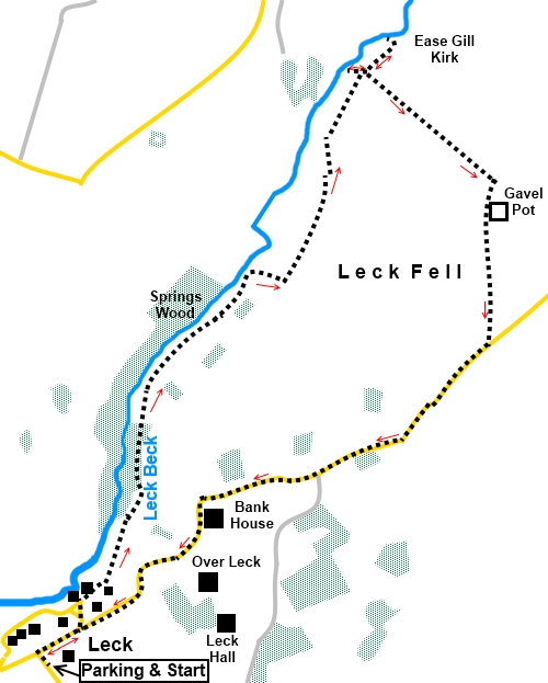
To view route as a dynamic Ordnance Survey map click here. Introduction: This Leck Fell walk feels like it should be in the Yorkshire Dales because of the limestone scenery but it is in fact in Lancashire. It is a bleak, treeless but peaceful area of high moorland and you are unlikely to meet any/many other walkers. Below your feet is an extensive network of potholes. The route passes one large, fenced off pothole, Gavel Pot but there is no access without a permit and definitely no access unless you know what you are doing and have the right equipment! Much of the walk utilises Access Land where you are free to wander but be careful of any unfenced potholes! Leck Beck and Ease Gill run through the fell and provide some attractive and dramatic views. This route only provides glimpses of Ease Gill’s potential in particular and I hope to return to explore more extensively in the future. There is one steepish climb of about half a mile, which is why the walk earns an amber section but the compensation is that the last two miles, whilst on a tarmac lane/road are all downhill and there are some lovely views on the way. This being a moorland walk, there can be wet sections and gaiters are recommended. The walk starts from the large car park by St Peters Church in Leck. To get there; turn off the A65 at Cowan Bridge signposted for Leck. Go straight over the crossroads and next right for the church. Start: Turn right out of the car park and at the road junction, turn right again.
Pass an electricity sub-station on the left, then turn left at the next road junction. There is a post box on the corner. At the ‘T’ junction, turn right on the single track, dead end road (SD 644670). Just after a public footpath fingerpost, the track divides. Bear left passing Low Leck House. Follow the obvious track, crossing a ladder stile. Just after going over a stream, via a concrete bridge, the track divides. Go left. Enter a conservation area through a five bar gate and follow the track through the trees, ignoring a dilapidated, rusty bridge on the left. Pass a small wooden cottage and follow the track parallel with wall on the left. Go through a gate (or over the ladder stile), following the yellow arrow. A sign indicates you are entering Access land (SD 652786).
When the track divides, go right. Keep right as the track climbs. On reaching a post with a yellow arrow, with a green sign saying “Footpath this way” (SD 653787). Join a broad track at a ‘T’ junction and turn left. When it divides, keep right. Just after passing through a ruined wall, the path drops down into a small valley where there is a stream (SD 658793). Climb the far side and bear left towards Leck Beck. Cross another wall.
Note the next ruined wall to which you will return (SD 659798).
About two hundred yards after this wall, go through a walkers’ gate and turn immediately left. You soon come to a dramatic spot, looking down into the gorge of Ease Gill Kirk with a cave at the far side (SD 661800).
Climb back up to the walkers’ gate and retrace your steps to the ruined wall. It is not overly clear but this is in fact a cross roads of paths. They are not marked on the OS map but this is Access Land, so paths can appear anywhere! Turn right briefly for a good view of Leck Beck and a waterfall by Whittle Hole.
Return to the ruined wall (SD 659798) and continue straight ahead, up its left hand side climbing the steep fell. As you climb, you get good view to Casterton and Barbon Fells. Ahead of you is the mass of Gragareth, the highest hill in Lancashire at 2056ft (627 metres). If you look closely, or have binoculars, you may be able to make out the large cairns on the summit, known as the Three Men of Gragareth – although there seemed to be six when I walked to them!
Crest the first hill with rocky outcrops. As you crest the second, if you look to the right, you should see a broad grassy track. If in doubt, you can continue to follow the wall to the road and turn right but taking the grassy track cuts a corner. Make your way across the fell to the grassy track and follow it. You pass a large fenced of pothole at SD 666791, which I think is Gavel Pot.
The track leads to a stone wall, at a corner. The track starts off parallel with the wall then gradually peels away before rejoining it at the road (SD 666783). Turn right along the road for about two miles to return to Leck.
If you need to buy any hiking equipment/clothing before your trip see the Hiking Store All information on this site is given in good faith and no liability is accepted in respect of any damage, loss or injury which might result from acting on it.
| | |||||||||||||||||

.jpg)
.jpg)
.jpg)
%20St%20Peters%20Church%20at%20Leck.jpg)
%20Approaching%20the%20wooden%20cottage.jpg)
%20Alongside%20Leck%20Beck.jpg)
%20Bleak%20Leck%20Fell.jpg)
%20View%20across%20the%20valley%20near%20Smithy%20House.jpg)
%20Looking%20down%20into%20Ease%20Gill%20Kirk.jpg)
%20Waterfall%20on%20Leck%20Beck%20at%20Whittle%20Hole.jpg)
%20View%20to%20Casterton%20and%20Barbon%20Fells.jpg)
%20Gragareth.jpg)
%20Telephoto%20shot%20of%20the%20Three%20Men%20of%20Gragareth.jpg)
%20Gavel%20Pot.jpg)
%20Limestone%20outcrops%20by%20the%20road.jpg)