|
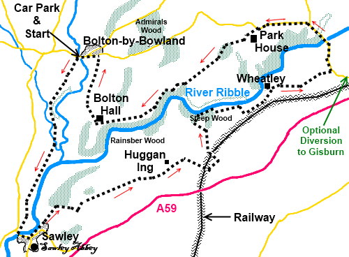
Bolton-by-Bowland Circular
Starting point and OS Grid reference: 
Bolton-by-Bowland
– free car park (SD 784494)
|
Ordnance Survey Map
Explorer
OL41 – Forest of Bowland and Ribblesdale.
Buy this map from
List
of OS Maps
Note: If you use OS Maps on-line, you can download this route via this
link
| |
Distance: 10
miles (excluding detour to Gisburn)
|
Date of Walk: 2
March 2012
| |
Ascent:
Descent:
See Walking Time Calculator
|
922ft (281m)
922ft (281m)
| |
Traffic
light rating: 
(For explanation see My
Walks page)
| |


For advice on .gpx files see
My
Walks page
|

Click
the PDF logo above to give a printable version of this walk without the
photos.
|
To
view route as a dynamic Ordnance Survey map click here.
If you need to buy any
hiking equipment/clothing before your trip see the Hiking
Store
Introduction:
Bolton-by-Bowland
is a lovely stone built village on the edge of the much under rated and
under discovered Forest of Bowland, by Skirden Bridge. This walk starts
there and takes you on a circular route via the equally attractive Sawley
with its remains of a Cistercian abbey originating from the 12th
century. In places, the route follows the River Ribble and also part of the
Ribble Way. The walk is through pleasant level countryside and is easy but
can be very muddy in places. It is best done after a dry spell or in winter
when the ground is frozen. Gaiters are strongly recommended. Considering the
Ribble Way is one of the recognised long distance National Trails, those
responsible for some of its signposting, stiles and gates should be ashamed!
It is difficult to find the correct route for
some of this walk, which is why the route description is rather long.
The walk starts at a free public car park in
Bolton-by-Bowland where there are toilets and a basic information centre.
There are refreshment opportunities at pubs in Bolton-by-Bowland, Sawley and
Gisburn (subject to a short diversion) all subject to timing.
To get to Bolton-by-Bowland, turn north off
the A59 in Gisburn (signposted).
Start:
Out of the car park (SD 784494), turn left over Skirden Bridge. Immediately over the
bridge, turn left on the tarmac, private road, to Bolton Mill Farm. There is
a public footpath fingerpost.
As the tarmac track bends sharply left to the
farm (SD 782490), go straight ahead over a stone stile marked with a yellow
footpath arrow and a large sign. Ignore the kissing gate on the right and
follow the fence line up the field.
Go through the next kissing gate and follow
the left hand boundary of the field along by the trees, crossing another
stile. At the end of the trees go straight ahead to the kissing gate and
beyond.
Over the next stile, follow the strip of land
between the two becks, Holden Beck on the right and
Skirden Beck on the left. Go over the footbridge (SD 780481) and
follow the boundary of the next field and turn left over a bridge. Pass one
gate and look out for a stile on the left. If you reach a second gate, you
have passed it!
%20Skirden%20Beck.jpg)
Head for the right hand corner of the next
field from where the path bears left through the newly planted trees. Once
through the trees, a very prominent sign tells you that the path bears off
to the right (SD 776481) and is marked by cones. Be warned here, that
although it is tempting to follow the riverbank, the right of way most
definitely does not. A local resident told me that this principle is very
strictly enforced by regular patrols so, to avoid the wrath of the water
bailiff, stick to the marked route. After crossing a little stream, turn
left to follow the hedge line (do not go through the gate).
Come on to the road by Sawley Bridge and
after crossing it, turn left. Walk along the road to the Spread Eagle pub.
Here, our route turns left, along the lane “Sawley Old Brow leading to
Laneside” If you want to visit the abbey ruins, turn right at the Spread
Eagle and they are clearly visible on the left (English Heritage – free).
Return to Sawley Old Lane and walk along it.
%20View%20approaching%20Sawley.jpg)
%20River%20Ribble%20at%20Sawley.jpg)
%20View%20to%20Sawley%20Bridge.jpg)
%20Sawley%20Abbey.jpg)
As the road bends to the right, carry on
straight ahead through the gateway for Sawley Lodge.
The next section follows the Ribble Way indicated by a blue
fingerpost.
Look out for a walkers’ gate on the right
and go through this, turning left on to a broad track to follow the Ribble
Way. Stay on this track through the middle of Dockber Farm and look out for
a gateway on the right (SD 789473) continuing the Ribble Way.
This area is used for an annual Beat Herder
Festival and there are one or two unusual indicators. The first is an
archway of shoes through which you pass. From here, head for the “ancient
stone circle” (not that ancient!), passing the corner of a copse of trees
(not through it as indicated on some older maps). You will also see a
“Sword in a Stone” - but I do not think you get to be king/queen if you
can remove it!
%20Archway%20of%20Shoes.jpg)
%20Sword%20in%20the%20stone.jpg)
Pass to the right of the stone circle and
follow the Ribble way signs, going through a metal gate to follow the
bridleway between two rows of trees and turn right by Huggan Ing farm
then immediately left staying on the Ribble way. At the end of the
next field, turn right. There is a concrete water tank here (SD 800478) with
360° views and it is a convenient spot to perch for sandwiches.
From the water tank, bear left to Gisburn
Coates Hall then left along the farm lane. Cross the railway line then go
left.
As you approach the next farm, (Gisburn
Coates farm), go left and over the grassy bridge (SD 804479) to re-cross the
railway, then bear right heading for the left of Long Holme Row farm. Cross
an “ordinary” stile then a small ladder stile. Turn left past the barn
on to the farm track and when it bends left, go straight ahead over a stile
(still on the Ribble Way).
Cross another stile at the end of the field
then down some rough steps to follow the right hand side of the stream. The
path zig-zags down through the aptly named Steep Wood to the River Ribble
where you turn right (SD 802485).
%20River%20ribble%20valley.jpg)
NB. Since I did this walk
(2012), the route of the footpath has changed in that from a barn (New
Laithe) (SD 812487), the footpath route no longer goes via the farm
buildings at Wheatley. The resident of the property has provided the
following paragraphs to replace mine. Current 1:25000 OS maps are correct but
if you are using an older one beware.
Continue to follow the Ribble way markers passing through a wooden gate in the corner and keeping the hedge line and stone barn on your left. Walk up tarmac drive and turn left before Higher Laithe farm building at top of hill.
Just beyond the buildings, bear right over the brow and continue down to a walkers’ gate then follow the stream to the right. Pass over the plank bridge footbridge up through the wood, through two kissing gates then bear right heading for another to the right of the pink farmhouse (Coppice Farm).
Go through the farmhouse and follow the drive
to the road (SD 822491) (this section is also the Pennine Bridleway). If you
wish, turn right here and walk along the road for half a mile to visit
Gisburn where there are pubs/toilets, then return to this point. Otherwise,
turn left.
Stay on the road for ¾ mile, crossing the
river bridge where the Ribble Way diverts off right – you stay on the
road. Pass a road off to the right then, when the road bends sharply right
(SD 811498), continue straight ahead along the track to Park House Farm,
passing it to the right. There are good views along here to Pendle
Hill.
%20View%20to%20Pendle%20Hill.jpg)
After Park House Farm, bear left and descend
to cross a stream via a footbridge then go left then over a stile and turn
right to follow the right hand field boundary. At the top of the rise, keep
straight ahead to the right hand corner of a copse of trees where there is a
gate (SD 807496). Go through this and follow the path through the right hand
side of the trees. Follow the right hand fence line once out of the trees.
At Fooden Hall Farm, follow the track through
the farm, going right in the farmyard then turn left signed for Bolton Hall
just past a metal barn. After the next barn on the right, turn right, again
signed for Bolton Hall. The path follows the left hand side of the field
where there is what could have been a sunken lane.
Go through the kissing gate at the end and
far below you on the left is the River Ribble once again. Follow the obvious
path to the left of a small concrete building. The path is now clear across
the fields through various kissing gates and arrives at a newish looking
stone barn with a metal roof. Turn right.
%20Approaching%20Bolton%20by%20Bowland.jpg)
At Bolton Hall Farm (SD 787483), turn right
and follow the long drive to the road. Bolton Hall itself was demolished in
the 1950s and the house conversions on this site are now known as King
Henry’s Mews. Turn left here into Bolton-by-Bowland. Note the
stocks by the remains of the 13th century cross on the village
green.
%20Bolton%20by%20bowland%20Village%20Green%20and%20Stocks.jpg)
If
you need to buy any hiking equipment/clothing before your trip see the Hiking
Store
All information on this
site is given in good faith and no liability is accepted in respect of any
damage, loss or injury which might result from acting on it.
|


.jpg)
.jpg)
.jpg)