
|
|
|
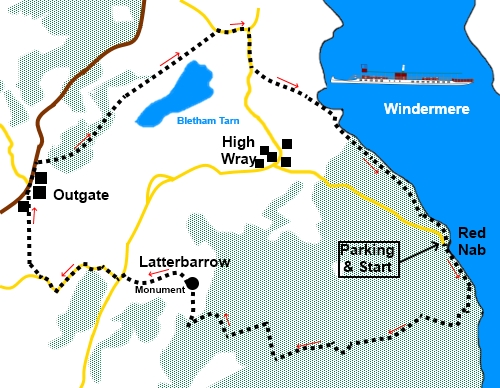
To view route as a dynamic Ordnance Survey map click here. Introduction: Although Latterbarrow only rises to 803ft (245m), its summit rewards you with an amazing 360° view incorporating some of the best known Lake District hills and the length of Windermere itself. The summit is crowned by a monument/beacon/obelisk – I hedge my bets because I have not so far been able to establish its purpose. There is no plaque or notice on it. If anyone knows the information, I would be happy to incorporate it here. This route also incorporates a lovely section of the path along the west shore of Windermere and an opportunity to visit Wray Castle. The going is straightforward with a relatively gentle climb to the summit. There are some good picnic spots on rocks or just the short grass at the summit of Latterbarrow and the route also passes the Outgate Inn at about the halfway point, where you should be able to gain sustenance – check the website. The route starts from a free, rough car park at Red Nab on the western shore of Lake Windermere (I insert the word ‘Lake’ only to differentiate from the town. As ‘mere’ is already in its name!). To get there, take the ferry, then the B5285 from Bowness on Windermere. Alternatively, from the Newby Bridge side, follow signs for Hawkshead where you can join the B5258. Whichever way you come, do not go into Hawkshead but follow the signs for Wray. Arrive at High Wray then turn right at a small triangle of grass following the road sign for “Windermere Ferry” and “Unfit for Vehicles after 1 mile”. As you reach the end of the tarmac, the parking is on the left by the lake’s shore. Getting to the start is probably the most difficult navigational challenge of the walk! Start: Leave the car park (SD 386994) and turn left along the wide track, following the fingerpost for “Bark Barn Ferry ¼ Mile”.
Follow the track for a third of a mile and immediately after a large white painted cottage on the right, turn right up a stony track through the woods, following a fingerpost for “Hawkshead 3 miles” (SD 387989).
At a three-way fingerpost, follow the blue bridleway arrow and “Hawkshead via Guides Posts”. At SD 379987 pass Scab Moss on the right where an information board tells you a little about the restoration of this peat bog. Shortly after Scab Moss, go straight over a crossroads of tracks and follow the fingerpost for “Sawrey via Tarns”. The track forks. Take the right fork for “Hawkshead Guide Posts”. Arrive at another crossroads of tracks (SD 375986), with a four way fingerpost, as you come out of the trees. Continue straight ahead for “Hawkshead 2 miles”.
The view east along here is quite good. You will come to the end of a stone wall. The main track continues to the left of this but you need to fork right to follow the yellow footpath arrow (SD 373986). At the next junction of paths (SD 373988), turn left. My original intention had been to continue for another 150 yards or so and follow another path left but this way was very indistinct and the route I have recommended is basically the most obvious way.
Follow this clear path to a stile (SD 367988). Cross and turn right to follow the fingerpost for Latterbarrow. The monument at the summit should be in clear sight. Arrive at the monument tower where there are fabulous views of some of the major hills. You may recognise some but if you use a compass, you can identify (to name but a few): The Langdales - 300° Crinkle Crags and Bow Fell – 297°
Before continuing the route, it is worth walking the few yards east (right as you approach the monument) for the view over Windermere. The onward route is more or less straight on, based on your direction of approach to the monument. The path does divide after a few yards but comes back together a little further on. Follow the path down to a small copse of trees where you join another path. Turn right. A sign on a post here tells you have joined the Far Trade Way. This was new to me and is a long-distance heritage trail from Garstang to Keswick, created to promote the positive impact of using Fair Trade products.
Continue to the road and turn left along it. After a few yards, turn right at the road junction and continue along it for about half a mile. After a group of buildings, turn right through a five bar gate, more or less opposite a National Trust sign with footpath information (SD 355000). Within a few yards, there is a four way fingerpost. Follow the direction for “Outgate ½ mile”. This is an easy path to follow. At the end of the second field, join a gravel path and turn right, eventually emerging (conveniently!) at the Outgate Inn. Turn right along the road for about two hundred and fifty yards. Immediately after the National speed limit sign, turn right, on a broad track, in the direction of the fingerpost for “Low Way 1½ miles” The track drops down to join a neatly finished gravel track, part of a cycle way. Turn left to follow the fingerpost for “Wray Castle 1 mile”, passing Bletham Tarn.
At NY 368009, join another clear track and turn right, followed by another right turn a few yards further for “Wray Castle ½ mile”.
At the road, turn right to pass the entrance to Wray Castle. Just past the entrance, turn left following a public bridleway sign for “Belle Grange 2 miles”. Follow the path down to the lakeside and turn right to follow the shoreline back to the parking.
If you need to buy any hiking equipment/clothing before your trip see the Hiking Store Before venturing on to the Lake District fells, for your own safety, please check the Fell Top Conditions All information on this site is given in good faith and no liability is accepted in respect of any damage, loss or injury which might result from acting on it.
| | |||||||||||||||||

.jpg)
.jpg)
.jpg)
%20view%20of%20Windermere%20at%20the%20start%20of%20the%20walk..jpg)
%20Mossy%20Rocks%20in%20the%20woods%20near%20Belle%20Grange.jpg)
%20View%20towards%20Helvellyn.jpg)
%20Latterbarrow%20with%20the%20Langdale%20Pikes.jpg)
%20Latterbarrow%20Monument.jpg)
%20Crinkle%20Crags%20and%20Bow%20Fell.jpg)
%20Panorama%20of%20Wndermere%20from%20Latterbarrow.jpg)
%20Fair%20trade%20way%20sign.jpg)
%20Bletham%20Tarn.jpg)
%20Langdale%20Pikes.jpg)
%20Entrance%20to%20Wray%20Castle.jpg)
%20Bench%20by%20Windermere.jpg)
%20Tranquility%20at%20Windermere.jpg)