|
Crinkle
Crags and Bow Fell
Starting point and OS Grid reference:

National
Trust pay and display car park at the Old Dungeon Gill Hotel (NY 287061)
|
Ordnance Survey Map
OL6
- The English Lakes - South-western area.
Buy this map from
List
of OS Maps
Note: If you use OS Maps on-line, you can download this route via this
link.
| |
Distance: 7.9 miles
|
Date of Walk: 21 May 2012
| |
Ascent:
Descent:
See Walking Time Calculator
|
1005m (3299ft)
1005m (3297ft)
| |
Traffic
light rating:


(For explanation see My
Walks page)
| |


For advice on .gpx files see
My Walks page
|

Click
the PDF logo above to give a printable version of this walk without the
photos.
|
To
view route as a dynamic Ordnance Survey map click here.
Introduction:
The Crinkle Crags walk has to be one of the best Lake
District walks. The views are beautiful, dramatic and exhilarating as you
work your way along the five summits of the Crinkle Crags ridge. Especially
impressive is the sight of Scafell
Pike. There are also good views of the
Langdale Pikes - in fact everywhere!
The walk is easily shortened by omitting the
Bow Fell leg but as you have done most of the hard work by this time, it
seems a shame not to “bag” this 2960ft (902 metres) top too.
It is recommended that you walk Crinkle Crags
in the direction given (i.e. south to north) because you will then approach
and see the “Bad Step” from below when it can be easily circumvented,
rather than it catching you by surprise from the top.
A further safety issue is that it is very
important to leave Bow Fell in the right direction as there are very steep
drops in the wrong ones! In good visibility there should be no problem but
if the cloud descends, the right compass bearing is a reassurance,
especially as the summit is essentially a massive rocky pyramid and it may
be difficult to pick out from the surrounding rocks, the cairns, which
indicate the correct route.
There are considerable boulders to cross and
it is strongly recommended that boots be worn for ankle support.
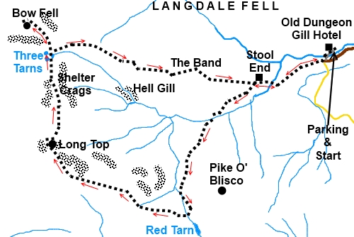
The walk starts from the National Trust car
park at the Old Dungeon Ghyll Hotel. You actually turn into the Hotel
approach road to get to it. To get there, take the A593 out of Ambleside and
at Skelwith Bridge, turn right on to the B5343. The car park is on the right
after 4½ miles at a sharp left hand bend.
Refreshments are available afterwards at the
excellent Hikers Bar at the Old Dungeon Ghyll Hotel.
Start:
Exit
the car park entry road and at the junction with the hotel drive,go straight ahead through the gateway, following the
fingerpost for The Band and Oxendale. Immediately after going through the
gateway, bear left crossing the beck by the little stone bridge. On meeting
the road, turn right following the public footpath fingerpost (NY
265060).
Follow the tarmac farm drive to Stool End
Farm and go through the farmyard following the clear footpath signs. Stay on
the broad stony track alongside the wall and note the narrower stony path
you meet on the right (NY 276057), lined with rocks, which will be your
return path after descending The Band.
%20Approach%20to%20Stool%20End%20farm.jpg)
Stay on the main track which leads to more
open land. Go through a kissing gate bearing left. By the next gate, spot
the footbridge over the beck. Cross this and climb the hill via the obvious
path.
%20Langdale%20Pikes.jpg)
%20View%20Up%20Oxendale.jpg)
%20Another%20View%20of%20the%20Langdale%20Pikes.jpg)
Climb this well “manicured” path to the
col. At what appears on the ground as a ‘T’ junction of paths (although
technically a footpath does go straight on) by the stream, turn right (NY
267039).
The obvious path climbs to the foot of a
small rocky bluff. You can climb this if you wish (although there is little
point) or take the path which goes round to the left then right almost 360°
and at a cairn, branches left climbing up the rocks.
The route now more or less follows the top of
the Crinkles ridge and is marked by a series of cairns. Views in all
directions are great but note especially Scafell Pike to the northwest, the
Langdale Pikes to the northeast and Pike O’ Blisco to the southeast. The
view down the Langdale valley is also wonderful.
%20View%20down%20the%20Langdale%20Valley.jpg)
%20View%20North%20Along%20Crinkle%20Crags.jpg)
When the route descends to a short grassy col
(NY 249047), you will see ahead the mass of Long Top and what looks like a
rectangular cave formed by a rock fall (see photo). This is the section
known as the “Bad Step” and leads up on to Long Top. To avoid the
scramble/climb, take the path round to the left. It then swings right in an
arc passing a small tarn on the left.
%20Approaching%20Long%20Top%20and%20the%20Bad%20Step.jpg)
From the summit of Long Top, the highest of
the “Crinkles” at 2816
feet (859
metres), resume following the cairns along the ridge.
The ridge eventually drops down to a broad
col at the Three Tarns (NY 248059). Ahead of you is the mass of Bow Fell and
the path up is obvious, as are some of the perils of coming off Bow Fell in
the wrong direction!
%20Bow%20Fell%20from%20the%20Three%20Tarns.jpg)
At the far side of the col at a stone cairn,
a path joins from the right (NY 249062). This is the top of the path which
descends the grassy ridge known as The Band and is ultimately our route down
(or the point where you can cut the walk short - note this is the path north
of the stream Buscoe Sike, not the one to its south which goes via Hell
Gill).
To reach the top of Bow Fell, stay on the
clear path ahead. This passes some impressive large slabs of rock before
arriving at the large rocky pyramid which forms the summit. The highest
point is obvious and although there are cairns leading you there, in reality
it matters little which route you take. Just watch your step to avoid
turning an ankle.
%20Rocky%20Pyramid%20Summit%20of%20Bow%20Fell.jpg)
There are no trig. points or cairns to mark
the conquest of Bow Fell, just a rocky summit but the views from it are
superb (NY 245065).
%20View%20along%20Crinkle%20Crags%20from%20Bow%20Fell%20summit.jpg)
If you have noticed the steep cliffs on the
approach, you will appreciate that it is vital to come off the summit in the
right direction. If visibility dictates compass use, come off the pyramid at
about 65° magnetic and at the pyramid base about 125° magnetic, going to
about 150° after around 300 yards, will take you back to the Three Tarns
col. You should double check these bearings for yourself and do not forget
magnetic variation – see Ordnance Survey map for details.
Return to the top of The Band and at the
cairn, go left. The path is well “manicured” and as you reach the
bottom, you will recognise the path bordered by the stones referred to
earlier. Turn left by the wall and retrace your steps to the car park.
If you need to buy any
hiking equipment/clothing before your trip see the Hiking
Store
Before
venturing on to the Lake District fells, for your own safety, please check
the Fell
Top Conditions
All information on this
site is given in good faith and no liability is accepted in respect of any
damage, loss or injury which might result from acting on it.
|


.jpg)
.jpg)
.jpg)