|
Kentmere
Pike and Harter Fell from Longsleddale
Starting point and OS Grid reference:

Rough
car parking where the tarmac ends at Sadgill in Longsleddale (NY 484057)
|
Ordnance Survey Map
OL7
The English Lakes – South Eastern Area.
Buy this map from
List
of OS Maps
Note: If you use OS Maps on-line, you can download this route via this
link.
| |
Distance: 7.4
miles
|
Date of Walk: 23 April 2012
| |
Ascent:
Descent:
See Walking Time Calculator
|
650m (2131ft)
650m(2132ft)
| |
Traffic
light rating:


(For explanation see My
Walks page)
| |


For advice on .gpx files see
My Walks page
|

Click
the PDF logo above to give a printable version of this walk without the
photos.
|
To
view route as a dynamic Ordnance Survey map click here.
Introduction:
Kentmere Pike is usually approached
from the hamlet of Kentmere as part of the popular Kentmere Horseshoe.
However, parking at Kentmere is very limited and that walk is more arduous.
Longsleddale is almost a forgotten valley, quiet, tranquil and picturesque.
Kentmere Pike and Harter Fell provide a respectable walk in its own right.
There are great views of virtually all the main Lake District peaks from the
summit of Kentmere Pike. Cross Fell and even Ingleborough
in the Yorkshire
Dales can also be seen.
This walk is very easy to navigate and is
ideally suited to anyone who is a little unsure of their navigational
skills, wants to practise them or is perhaps going for a first taste of the
higher Lakeland fells. It would be tempting fate to say it is impossible to
get lost but there are plenty of useful navigational features en route which
make it less likely.
The footpath ascending Kentmere Pike itself
to Harter Fell is not shown clearly on the 1:25000 OS map as a green dashed line but
as a black dotted “path”. As this coincides with a wall line and a
parish boundary, you need a magnifying glass to differentiate. However, the
well trodden route is clear on the ground.
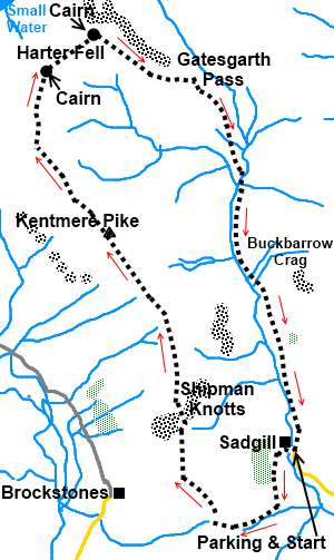
The walk starts from the point where the
tarmac road along Longsleddale ends by the bridge over the river at Sadgill.
There is probably parking for a dozen cars or so if parked sensibly.
Longsleddale is accessed by turning west off the A6 between Kendal and Shap
(signposted).
Start:
Cross the bridge over the River Sprint and after about 100 yards, turn
left to follow the public byway fingerpost “Stile End 1½ miles”. At the
farm at Low Sadgill, turn right, following the fingerpost for Kentmere along
the broad stony track.
%20Bridge%20over%20the%20river%20Sprint%20at%20Sadgill.jpg)
%20View%20up%20Longsleddale.jpg)
Remain on this track passing another
fingerpost for the public byway for High Lane and Kentmere. Ignore two paths
off to the left just after the fingerpost. The track now crosses land which
is a bit more open and follows the course of the wall to your right.
As you reach the top of a rise, the view
opens out before you and the wall curves away to the right of the track.
About 100 yards ahead, there is a gate across the track. Go through this and
then turn right on the obvious track which climbs the hill (NY 476050).
The path begins to follow the course of the
wall on your right which guides you up the steepest part of the ascent. The
path meanders a little, to find easier ground but you should never be far
from that wall.
At a small rocky outcrop, there are good
views of the Kentmere valley, Lake Windermere and Morecambe Bay.
%20Upper%20Kentmere%20Valley.jpg)
The hill widens out to broader plateau and
the path swings away left from the wall to a ladder stile over a wall ahead.
Cross this and follow the clear path to the summit. There is a summit cairn
and the trig point (NY 466078) is just over the wall, with a stone step
stile to access it. The altitude is 730 metres (2,397 ft).
%20Panoramic%20view%20at%20Kentmere%20Pike%20summit.jpg)
%20Distant%20View%20of%20Scafell%20Pike.jpg)
%20Telephoto%20shot%20of%20Scafell%20Pike.jpg)
The walk continues straight ahead, keeping
the wall on your right. The wall guides you along the summit. It then
changes to a fence. You continue to follow this fence passing a stone cairn
on Harter Fell marking the junction with the path from Nan Beild Pass (NY
460094). Harter Fell is slightly higher than Kentmere Pike at 778 metres
(2,552 ft). The cairn is a jumble of rocks and old ironwork and indicates
where you return to green marked footpaths on the OS map. Turn right on to
this, continuing to follow the fence line. Ignore any small stiles across
the fence.
Pass a second similar cairn (almost a double
cairn). There are good views from here over Haweswater, which supplies water
to Manchester and in the distance, straight ahead from your direction of
approach, is Cross Fell and you might catch a glimpse of the Civil Aviation
Authority's air traffic control radar dome on Great Dunn Fell.
%20Double%20Cairn.jpg)
%20Haweswater.jpg)
%20Small%20Water.jpg)
Continue to follow the fence as it bends
right. You are now on a very clear stony track running parallel with the
valley below. After 5/600 yards, the track and the fence part company. Just
stick with the track which is unmistakable.
The track descends to join a broader one at
Gatesgarth Pass (NY 474093) where you turn right. Simply follow this track
all the way back to Sadgill. After passing some old sheep folds, there is a
two way fingerpost but neither arm relates to your direction. Just stay on
the main track. The River Sprint provides company from this point onwards
with some attractive waterfalls.
%20Looking%20Down%20Longsleddale.jpg)
You will pass a large rocky crag on the left.
This is Buckbarrow Crag, popular with climbers and in spring you may see
ravens that nest there (when climbers are banned!).
If you need to buy any
hiking equipment/clothing before your trip see the Hiking
Store
Before
venturing on to the Lake District fells, for your own safety, please check
the Fell
Top Conditions
All information on this
site is given in good faith and no liability is accepted in respect of any
damage, loss or injury which might result from acting on it.
|


.jpg)
.jpg)
.jpg)