
|
|
|
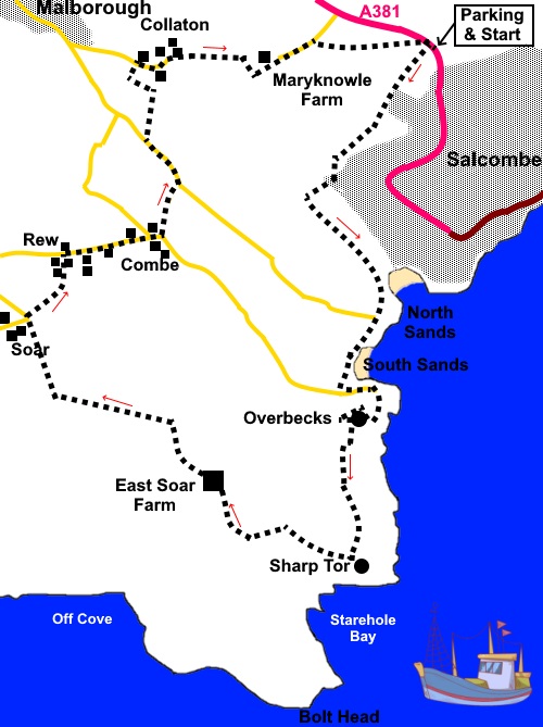
To view route as a dynamic Ordnance Survey map click here. Introduction: Having visited the Salcombe area for years, I have walked all the nearby coastal footpaths at some time and was looking for a different route. I also enjoy a visit to the Overbecks National Trust garden at Sharpitor so what could be better than a walk which satisfied both objectives. Overbecks is much better visited on foot, as the approach roads to it are narrow, quite congested and I guarantee if you try to take the car, you will spend quite some time backing up! I also realised that although I had passed below Sharp Tor on the coast footpath several times, I had never actually been to the summit and so this route was contrived. There is a slight overlap with my Bolberry Down to Bolt Head walk. Sharp Tor provides spectacular views over the Salcombe estuary (technically a ‘ria’ as no river flows into it), and there are substantial dramatic rocky outcrops. There is a topograph outlining what you can see and close by, a memorial to the Salcombe lifeboat disaster of 1906. North and South sands are pretty bays, which also feature. The walk also passes Bolt Head Airfield, a legacy of RAF Bolt Head. Construction started in 1940 an it became a strategically important, coupled with RAF Hope Cove nearby with its secret radar installation. It was a very active airfield, in particular for emergency landings for returning fighters. After the war it became home to a secret nuclear bunker which would have provided a limited continuing administration in the event the worst happened. It is now an unmanned farm strip. The walk starts from a large pay and display car park on the A381, just before you turn down to Salcombe itself. This avoids getting involved with the narrow streets of Salcombe and is reasonably priced (SX 733393). Start: Facing the road, exit the car park via the walker’s gate in the right hand corner. Cross the road and turn right along the footpath for only fifty yards or so, then turn left to follow a public bridleway fingerpost (SX 732394). There is also a sign for Motherhill Farm. Just before you get to the farm, fork left, again following the public bridleway fingerpost.
The path arrives at a broad gravel drive, at a three way fingerpost. Turn right following the one for the public bridleway. The path curves round in front of the house and then turns left at a three way fingerpost, through a gate. Continue following the public bridleway sign. The path climbs briefly to a broader track (SX 726386). Turn left along this. There is a post on the right with a multitude of bridleway blue arrows. Follow this broad track until it reaches the road at North Sands where you turn right along the road. However it is first worth the few yard detour to see this pretty bay.
The road climbs steeply. Continue to follow it, ignoring a junction, from where it descends to another pretty bay, South Sands.
Pass another junction and keep going. You reach a ‘No Through Road’ sign and a brown tourist sign for “Overbecks” (SX 728376). Keep
following the ‘No Through Road’ until it turns sharply right with a sign
for Overbecks garden. The broad track straight ahead is the coast path to
Bolt Tail. Pass the entrance to the gardens and continue along the tarmac path, alongside the wall of the gardens. It becomes a stony path.
Shortly after leaving the Overbecks boundary wall behind, climb some steps on the left. At SX 728371 is a memorial to the Salcombe Lifeboat Disaster. The topograph at Sharp Tor is a little further on.
From Sharp Tor, follow the path inland, behind the bench. Arrive at a three way fingerpost (SX 723368). Turn right, for “East Soar Outdoor Experience ½ mile” and “Marlborough 4 miles”. Follow the path up the field, following the left hand boundary and ignoring a path off to the left, until you reach the farm. Here you can usually get refreshments in the barn – The Walkers Hut. Follow the farm drive past a small airfield to a car park where there are information boards about the history of the airfield. Turn right along the road. As you get to a road junction (SX 712380), turn right through a gateway and immediately left following a public footpath fingerpost passing a cattle grid. As the broad track you are following curves right to a barn, keep straight ahead following the path alongside the hedge. At the end of the first field, turn right under the power lines and immediately left, to follow the left hand boundary of the next field. At the bottom of this field, turn left, following a yellow footpath arrow. The footpath skirts the edge of the caravan park at Rew. As you get to a concrete section, bear right to continue following a grassy path. At the road, turn right to follow it to a junction at Combe (SX718384).
Turn right uphill along the road for a few yards, then left up a broad, unsigned track (SX 718384). Follow it as it turns right, continuing to climb and ignoring another track off to the left. At the road (SX 719387), turn left along it, for around two hundred yards. At SX 718389 turn right along a broad track. This point is directly opposite the caravan site in the distance that you walked round at Rew, At a tarmac lane, turn left and follow it round a sharp right hand bend. Just after passing Collaton Grange, turn right following the public footpath fingerpost to “Salcombe via Mary Knowle” (SX 719393). As you approach a thatched cottage, turn right following a public footpath fingerpost (there is a sign on the corner for “Mallow Brook").
By a bench, turn right on to a broad grassy footpath which narrows as it enters the woods. Follow the obvious path, crossing a stream in the valley bottom.
At a stile, cross and turn left in the direction of the yellow arrow. The path runs up the right hand side of the house where it joins the tarmac drive. Continue to a lane and turn right. After about two hundred yards, follow a public footpath fingerpost on the right (SX 727394), climbing steps to follow the path across the field to the diagonally opposite corner. Cross the stile and continue in the same direction, indicated by a yellow arrow, In the next field, follow the right hand boundary to a stone stile and heads for the opposite corner of this last field. Turn right at the road to return to the car park. If you need to buy any hiking equipment/clothing before your trip see the Hiking Store All information on this site is given in good faith and no liability is accepted in respect of any damage, loss or injury which might result from acting on it.
|
| |||||||||||||||||

.jpg)
.jpg)
.jpg)
%20Footpath%20descending%20from%20Salcombe%20car%20park.jpg)
%20North%20Sands,%20Salcombe.jpg)
%20South%20Sands,%20Salcombe.jpg)
%20Footpath%20alongside%20Overbecks.jpg)
%20View%20along%20the%20coast%20at%20Overbecks.jpg)
%20View%20over%20Overbecks%20wall%20to%20Salcombe%20estuary.jpg)
%20Memorial%20to%20the%20Salcombe%20lifeboat%20disaster.jpg)
%20Rock%20outcrops%20at%20Sharp%20Tor.jpg)
%20Topograph%20marking%20Sharp%20Tor.jpg)
%20Salcombe%20estuary%20from%20Sharp%20Tor.jpg)
%20Starehole%20Bay%20from%20Sharp%20Tor.jpg)
%20peaceful%20rest%20stop%20at%20Combe.jpg)
%20Thatched%20house%20at%20Collaton.jpg)
%20Wild%20orchids%20at%20Mary%20Knowle%20Farm.jpg)