
|
|
|
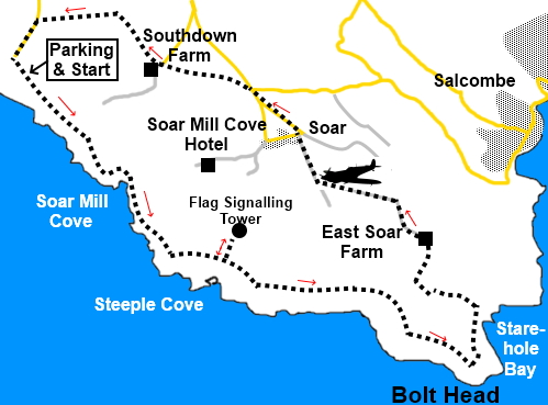
To view route as a dynamic Ordnance Survey map click here. Introduction: This walk from Bolberry Down combines both pretty and dramatic scenery, plus a couple of attractive sandy bays, Soar Mill Cove and Starehole Bay. Along the route, you come to an unusual stone-built pyramidal roofed tower. This is a rare survivor of a number of flag signalling stations which once lined the Channel coast, built by the Admiralty in 1794. Its main job was to keep watch for any approaching French ships and pass a warning to the English fleet. Originally, there would have been a small accommodation block attached. The tower is a Grade II Listed Building. The walk also passes Bolt Head Airfield, a legacy of RAF Bolt Head. Construction started in 1940 an it became a strategically important, coupled with RAF Hope Cove nearby with its secret radar installation. It was a very active arfield, in particular for emergency landings for returning fighters. After the war it became home to a secret nuclear bunker which would have provided a limited continuing administration in the event the worst happened. It is now an unmanned farm strip. You may be lucky enough to see some landings/takeoffs as I was. Depending on the time of year, the walk provides an opportunity to see a variety of wild flowers, birds etc. The walk starts from the National Trust car park at Bolberry Down. This has always been free but I noted a newly installed ticket machine. This was covered and out of action but I am not sure of its operational status/frequency. To get to Bolberry Down, turn off the Kingsbridge to Salcombe road (A381) into Malborough (just before the garage). Wend your way through its narrow street and follow the road signs for Bolberry then Bolberry Down. Start: From the parking (SX689385), head east along the coast path (with the sea on your right!).
After about half a mile, (SX 696376) the path splits the right hand fork just goes a short distance to a good viewpoint for Soar Mill Cove. Return to continue along the coast path.
Reach a three way fingerpost and continue for “Bolt Head” and “Soar Mill Cove”. Cross a footbridge at the head of Soar Mill Cove and continue the cost path beyond.
At SX 706370, pass another three way fingerpost and follow “Bolt head” and “Salcombe” but before doing so, it is worth the brief diversion to follow the fingerpost for “Lower Soar”, for a look at the unusual flag signalling station tower.
At SX 712367 pass another three way fingerpost, the left hand one of which points to “Malborough”. Continue following “Bolt Head” and “Salcombe”. At SX 716367 arrive at a four way fingerpost and a gate. Through the gate, bear right for Bolt Head. It is worth a careful climb on to the rocks at Bolt Head for a view down to the tip and the Mew Stone and Little Mew Stone, as long as you do not have vertigo issue.
There are good views here across the Salcombe Estuary to Prawle Point.
Follow the path round the coast to reach the lovely Starehole bay. The path drops down towards the rear of the bay. Just before going through a five bar gate, turn left, at a three way fingerpost for “East Soar Outdoor Experience” and “Soar Mill Cove”.
Climb the little valley until your way is barred by a wall and gates (there is a walkers’ gate with various arrows including, a yellow footpath arrow, pinkish arrow (National Trust) and blue arrow with a coffee cup (SX 722367). Ignore this and keep straight ahead and head for the far right hand corner of the field. Follow the path as it curves right, passing to the left of a barn. Follow the right hand boundary to a five bar gate, through which is a three way fingerpost . Turn left for “East Soar Outdoor Experience”. When the path opens into a field, follow the left hand boundary. At the far side of the field, go through a gate and bear left following the National Trust Arrow and the East Soar Outdoor Experience sign. At the farm, where you can often get refreshments, go straight through the farmyard and follow its access track, as it curves right.
As you get close to a radio mast, the track turns left and there is a small airfield, the legacy of RAF Bolt Head. There are good views here north to Dartmoor and Kingsbridge.
On reaching the tarmac lane, turn right, following the fingerpost for “Malborough 3 miles”. Ignore a road junction on the left and at a ‘T’ junction, turn right along the road. As you draw opposite the next junction to Rue, Combe and South Sands, turn left on a footpath, indicated by a fingerpost. Head for another fingerpost at the far side of the field and then bear slightly left following its direction. Follow the path to South Down Farm in the near distance. At the farm, cross the tarmac drive. Straight across it is a three way fingerpost indicating a link to the coast path but keep straight ahead. Just before reaching a rough car parking area, the path curves laft following a yellow footpath arrow. Reach a broad track. Cross straight over following a public footpath fingerpost. Join another footpath at a three way fingerpost and turn left for “Jacob’s Lane” and “Bolberry Down ¾ mile”, which will return you to your car. If you need to buy any hiking equipment/clothing before your trip see the Hiking Store All information on this site is given in good faith and no liability is accepted in respect of any damage, loss or injury which might result from acting on it.
| | |||||||||||||||||

.jpg)
.jpg)
.jpg)
%20Beginning%20the%20walk%20on%20Bolberry%20Down.jpg)
%20Hazel%20Tor.jpg)
%20Soar%20Mill%20Cove.jpg)
%20Looking%20back%20to%20Soar%20Mill%20Cove.jpg)
%20Rocky%20outcrops%20near%20steeple%20cove.jpg)
%20Approaching%20Bolt%20Head.jpg)
%20Flag%20signalling%20station.jpg)
%20Bolt%20Head.jpg)
%20Tip%20of%20Bolt%20Head.jpg)
%20View%20to%20Prawle%20Point.jpg)
%20Starehole%20Bay.jpg)
%20Views%20to%20Dartmoor.jpg)
%20Airborne%20at%20Bolt%20Head%20airfield.jpg)
%20Poppies%20by%20Bolt%20Head%20airfield.jpg)