
|
|
|
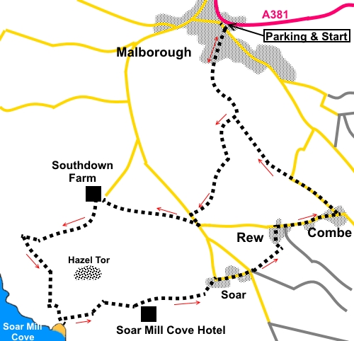
To view route as a dynamic Ordnance Survey map click here. Introduction: This walk is a shorter alternative to my Malborough to Bolt Head walk but approaches Soar Mill Cove by a different route affording good views of the dramatic Hazel Tor rocky outcrop. Soar Mill Cove is a relatively isolated inlet and has the blessing of an absence of road access, so keeping some of the crowds away. Having said that, it can get a little busy at peak times, as people park at Soar hamlet, or at the hotel (charge) and walk the three quarters of a mile or so down to the beach. Nevertheless, it is an attractive spot with interesting rocks and rock pools to scramble amongst. It is owned by the National Trust. Out to sea is the Ham Stone, a breeding ground for various sea birds. There is a little walking on very quiet lanes but there are some lovely cottages to see. Refreshments can be obtained at the Soar Mill Cove Hotel. The
walk starts from the free car park at the village of Malborough, opposite
the filling station (SX
710398). To get there, turn right opposite the garage on to Collaton
Road, off the A381 Kingsbridge to Salcombe road where the road bends
sharply. The car park entrance is on the left after 100 yards or so. Start: Exit the car park by the pedestrian gate in the top left hand corner, by the fitness equipment (important) and turn left down Collaton Road. Turn immediately right along Lower Town, then left down Well Hill, becoming Shute Park. As Shute Park bends right, bear left following the public footpath fingerpost.
Follow the footpath, passing between two large stone gateposts, until you reach a road (SX 710392). Turn right. Pass Scrumpy Lodge, following the road as it bends right then, as it bends left, turn off to the right following a public footpath fingerpost. Pass two houses, the latter being Stable End House, after which the route becomes a broad grassy track. Follow it through a walkers’ gate, indicated by a yellow arrow and stay on it as it rises gently. As it starts to level out, there are good views towards the sea.
Stay on the track to a lane and then turn right. On reaching the road (Soar Road) at a ‘T’ junction, turn left (SX 707384). Opposite the next road junction (which is signed for Rew, Combe and South Sands), turn right up some steps on to the National Trust property South Down Farm and follow the public footpath fingerpost, diagonally to the road. Part way across the field, you will see the next fingerpost. To the right are views over Malborough and towards Dartmoor. When you get to the fingerpost, follow its direction towards the farm in the near distance. There is a radio mast behind it. The valley leading down to Soar Mill Cove is clearly visible to the left, along with the prominent rocks of Hazel Tor.
At the far side of the field, turn right to follow its left hand boundary in the direction of the fingerpost. To the right are the remains of buildings dating from World War II when there was an important airfield close by. At the farm, cross a stone stile on to a lane (SX 701385). Turn left to follow the fingerpost “Link to Coast Path”, passing between the farm buildings, now holiday cottages. Just after the farm buildings, the track splits. Take the left hand fork which becomes tarmac for a while and follow it down past a couple of house (The Crag and Hamstone Cottage). The route enters a large rough field. Follow the track as it curves right, heading to the valley floor.
Pass some upright stones, part of an ancient field boundary and at a three way fingerpost, turn left for “ Soar Mill Cove ½ miles” (SX 694382). As you progress, you get a closer view of Hazel Tor.
As you go through a gate, a National Trust sign tells you that you are leaving South Down Farm. Follow the track straight ahead, indicated by a yellow arrow. At SX 697377, join the Coast Path by a three way fingerpost. Turn left to follow “Soar Mill Cove” and “Bolt Head” and arrive at Soar Mill Cove beach, via a ramp and steps.
The return is via the other set of steps and ramp, more to the right. Ahead is a three way fingerpost. Take the direction for “Higher Soar” and “Malborough”. Do not cross the bridge.
Cross two fields then join a broad track and turn right. It emerges on to a tarmac lane opposite the Soar Mill Cove Hotel (SX 703377). Turn left. Pass “The Old Cottage” and on reaching the road junction, turn right.
At the next road junction, cross straight over then go left to follow a broad concrete track, indicated by a public footpath fingerpost (SX 712380). When the track swings right to some large barns, branch off to follow a hedge on the left. Ahead, Salcombe comes into view.
At a gateway, branch slightly right indicated by a yellow arrow to walk along the right hand side of a hedge. The path drops down to follow the edge of Higher Rew Campsite (turning left). As you reach a concrete drive, turn right along a broad grassy track to the road (SX 713383). Turn right along the road for about 1/3 mile. Arrive at the small settlement of Combe and at the road junction, turn left, passing the lovely Pheasant Cottage.
Stay on the road for just over ¼ mile. Just after passing another thatched cottage, the road bends right. At the bend, go left through a kissing gate, following a public footpath fingerpost (SX 714387). Note, at first glance, it might look as though the path goes straight into the trees but in practice, it remains in the field just following the edge of them.
At the end of the field, the path does curve right into the trees. Follow the clear path through the trees until it comes out at a tarmac track, at the water treatment works. Turn right along the track following the public footpath fingerpost. You should now recognise the way as part of your outward journey, as it becomes a proper road. Ignore an old fingerpost on the right which serves to confuse. As the road bends right after Scrumpy Lodge, bear off left at the corner to retrace your steps to the car park. If you need to buy any hiking equipment/clothing before your trip see the Hiking Store All information on this site is given in good faith and no liability is accepted in respect of any damage, loss or injury which might result from acting on it.
| | |||||||||||||||||

.jpg)
.jpg)
.jpg)
%20Spring%20flowers%20on%20track%20leaving%20Malborough.jpg)
%20View%20over%20Malborough.jpg)
%20Looking%20towards%20Soar%20Mill%20Cove%20and%20Hazel%20Tor.jpg)
%20Hazel%20Tor.jpg)
%20Valley%20down%20to%20Soar%20Mill%20Cove.jpg)
%20Ancient%20field%20boundary.jpg)
%20Hazel%20Tor%20from%20below.jpg)
%20Soar%20Mill%20Cove.jpg)
%20Foxgloves%20above%20Soar%20Mill%20Cove.jpg)
%20The%20Old%20Cottage%20at%20Soar.jpg)
%20View%20over%20Salcombe.jpg)
%20Pheasant%20Cottage.jpg)
%20Cottage%20near%20turn%20off.jpg)