|
Malborough
to Bolt Head
|
Starting
point and OS Grid reference:

Free
car park at Malborough (SX 710378)
|
Ordnance
Survey Map
OL
20 South Devon – Brixham to Newton Ferrers.
Buy this map from
List
of OS Maps
Note: If you use OS Maps on-line, you can download this route via this
link.
| |
Distance: 8.4 miles
| |
Traffic light rating: 
(For explanation see My
Walks page)
| |


For advice on .gpx files see
My
Walks page
|

Click
the PDF logo above to give a printable version of this walk without the
photos.
|
To
view route as a dynamic Ordnance Survey map click here.
.jpg) Introduction:
This walk takes in some dramatic coastal
scenery, the superb beach at Soar Mill Cove with plenty of shelter to get
out of any breeze amongst the rocks and the promontory Bolt Head. There is
also the opportunity to see the National Trust exotic garden Overbecks (the
house is closed awaiting restoration). There is only a small amount of road walking mainly on the
approach to Salcombe. There is only really one moderately steep section out
of Soar Mill Cove but not quite enough overall to make me grade it amber. Introduction:
This walk takes in some dramatic coastal
scenery, the superb beach at Soar Mill Cove with plenty of shelter to get
out of any breeze amongst the rocks and the promontory Bolt Head. There is
also the opportunity to see the National Trust exotic garden Overbecks (the
house is closed awaiting restoration). There is only a small amount of road walking mainly on the
approach to Salcombe. There is only really one moderately steep section out
of Soar Mill Cove but not quite enough overall to make me grade it amber.
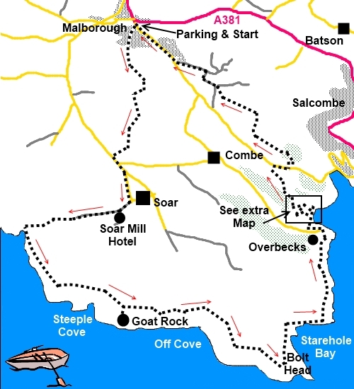
Start: The walk starts from the free car park at the
village of Malborough, opposite the filling station (SX 710378). To
get there, turn right opposite the garage on to Collaton Road, off the A381
Kingsbridge to Salcombe road where the road bends sharply. The car park
entrance is on the left after 100 yards or so.
Leave the car park by its entry road and at
Collaton Road turn right. At the first road junction on the left, before the
main road, turn left. This is Well Hill leading to Shute Park. Follow the
road down ignoring the right turn. As it bends to the right, take the track
straight ahead indicated by the public footpath fingerpost.
The track becomes a narrow footpath which
opens into a tarmac lane where you turn right. Follow the lane until it
swings left at a farm and take the public footpath on the right. Pass Stable
End House and go through the gateway straight ahead.
As the track rises, there are distant views
to the Salcombe Estuary (technically a ria) and Malborough village with its
church spire behind you. You reach Furzedown Farm quite suddenly. Turn right
up the tarmac farm track and at the road, turn left (SX 707834).
Within 300 yards, you come to a road junction
for Rew, Combe and South Sands. Carry straight on for Soar ¼ mile and at
the next fork in the road, turn right.
As the road divides at a grassy island, take
the right hand road for Soar Mill Hotel. A fingerpost shortly on the right
indicates you are heading for Soar Mill Cove. As the road bends left to the
hotel, continue straight ahead through the gate as indicated by the footpath
arrow. Follow the broad track down and turn left where the yellow footpath
arrow indicates and follow it down to the Cove. The lovely beach is ahead if
you wish to avail yourself but otherwise, at the bottom of the field (SX
698376), turn left to follow the coastal path indicated by the acorn sign.
%20Beach%20at%20Soar%20Mill%20Cove.jpg)
%20Coastal%20View%20with%20Soar%20Mill%20Cove.jpg)
After the climb from Soar Mill Cove, the path
levels out for a quarter of a mile or so. Ignore the finger post to the left
for Malborough and Soar, unless you want to shorten the walk.
The next fingerpost confirms the coastal path
is straight ahead but it is worth a brief diversion a few yards right to
Goat Rock for a good vantage point of the coast.
The
next fingerpost provides another opportunity to shorten the walk back to
Malborough but my route continues along the coast to Bolt Head. As the path
meets a broad track, turn right and right through the next gateway to Bolt
head. The next footpath post indicates the coastal path goes straight on but
turn right to access Bolt Head proper. The next gateway picks up the coastal
path again.
%20Bolt%20Head.jpg)
Through
a gate in a stone wall by a finger post proclaiming “Bolt Head”, descend
right then curve left by the rocky promontory where you catch sight of the
Salcombe Estuary. Below you (if the tide is out) are the beaches of
Starehole bay where, In 1936 the 4 masted sailing barque, "Herzogin
Cecilie" sank. Its outline is supposed to be visible at low tide but I
must confess to never having seen it on several visits!
%20Starehole%20bay.jpg)
%20Sharp%20Tor.jpg)
%20Salcombe%20Estuary.jpg)
The coastal path emerges at a road where a
left turn indicates Overbecks and Sharp Tor. Unless you are visiting
Overbecks, turm right and head for Salcombe. At the next junction, turn
right and follow the road past the South Sands Hotel (with an opportunity
for refreshment on the deck). Continue past the Tides Reach Hotel and ignore
the finger post to the left just by it.
You could now continue along the road to
North Sands and take a left bridleway to Malborough – probably the
simplest route to follow. However, the road here is narrow and quite busy at
times and I chose to get off it as quickly as possible and also explore some
of the lesser visited areas of Salcombe and envy the large houses! The route
is a bit complicated so concentrate!
Beyond the Tides Reach Hotel, continue up the
road and turn left at Froude Road. The public footpath fingerpost is hidden
behind the large gatepost. As you get to the property Oversteps, turn right.
After a few hundred yards, the path turns back on itself at a gate saying
Stowes Hill. The path eventually opens into a tarmac lane (De Courcy Road).
Continue and at the junction with a three way finger post, turn left.
After passing a house on the left called
Lillerby, pass between two metal posts and shortly after turn right at a set
of fingerposts down a narrow footpath. When you reach a broad track, turn
left. Follow this unmade road until you get to a timber house with a timber
fence and bear left on the footpath to the left of this property.
On reaching the road at a stile, turn left.
This lane will take you straight back to Malborough, about 1¼ miles.
However, if you want to avoid road walking and are up for some more
adventure, as you walk along the road, look out for a broad lane on the
right at a left hand bend (SX 724383). If you pass the entrance to Stowes
Hill Farm, you have missed it!
You reach a wall on the left. Follow this
along until you reach a footpath on the left at a gateway. Take this and
walk parallel to the hedge on the left, turning right at the corner of the
field (there is a faded footpath arrow). About halfway down the field, our
route goes left over a stile into the woods (SX 726383).
At the next junction of footpaths, keep left
and over the stile. Footpath arrows indicate the route. Over the next stile
and you are on Martins Way (still just a footpath). At the junction, turn
left.
At the next crossroads of footpaths, keep
straight ahead. The path comes out in a tarmac lane. Turn left. Follow this
lane ignoring the right hand turn at Higher Collaton until you reach a
‘T’ junction where you turn right into Malborough.
If
you need to buy any hiking equipment/clothing before your trip see the Hiking
Store
All information on this
site is given in good faith and no liability is accepted in respect of any
damage, loss or injury which might result from acting on it.
|


.jpg)
.jpg)
.jpg)