
|
|
|
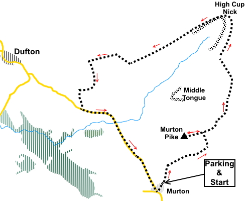
To view route as a dynamic Ordnance Survey map click here. Introduction: High Cup Nick is truly one of the wonders of Britain. It is something of a geological marvel. A classic, glacial ‘U’ shaped valley, with a rocky frieze around its edge, creating a really dramatic chasm in the hills. The rocks are part of the hard, igneous Whin Sill, evident at many points in the area, not least at the High Force waterfall in Teesdale, only some 8/9 miles away and Cauldron Snout, even closer at 4½ (both as the crow flies). Strictly, High Cup Nick is the very sharp end of the valley but the term is generally thought of as referring to the whole valley down which flows High Cup Gill. Walks to High Cup Nick often seem to be started from the village of Dufton and either end or start with a walk along the valley floor. However my route stays at a higher level round the perimeter, which has the benefit of providing spectacular views all the way round. It also has the bonus of “conquering” Murton Pike too, a not insignificant hill at 1950ft (594 metres). The view from Murton Pike’s trig point, across to the Lake District, is dramatic because the ground drops sharply away in that direction. The walk is straightforward with the only steepness of any note on the approach to Murton Fell. There is a purpose built, free car park at Murton, from where the walk starts. The easiest way to locate Murton is to turn off the A66 into Appleby-in-Westmorland. Turn NE off the B6542, on the SE side of the town centre, signposted for Hilton and Murton. Follow the road under the A66 until you get to Murton. At the cross-roads in the village centre, turn right. The car park is at the end of the lane. Start: At the car park entrance (NY 730220) is a two way fingerpost and you want to follow the direction shown for “Public Bridleway High Cup Nick 3¾ miles”. This is the wide, obvious, stony track bearing off to the left. I emphasise this because, especially if you go through the kissing gate, you could be side tracked by the footpath bearing right. This path goes into the Warcop Training Area, one of the MOD’s largest army training areas in the UK. At times access is barred, indicated by a red flag but in any case, it is the wrong path for this walk. Following the wider path, you soon pass a post with blue and yellow bridleway/footpath arrows. Follow the right hand blue arrow.
Stay on the broad track as it bends round to the right to curve in an anti-clockwise direction around Murton Pike, the unmistakable sharp peak on the left.
After a mile from the car park, at NY 740232, look out for a lesser worn path off to the left. There is a marker post a few feet above you. This path leads you along the flat ridge to Murton Pike with its trig. point. After surveying the view from Murton Pike, return to the broad track and turn left.
Follow the track for half a mile, until it levels out slightly by a marker post and take a fainter track off to the left (NY 745237).
You pass to the left of an area of stones where there are some crudely built stone shelters which could be useful for a lunch stop (NY 747240). The path is fairly obvious and parked with periodic posts.
It drops down into a little valley and climbs the other side (NY 747247). Continue to follow the path. It begins to follows a course more or less parallel with the High Cup Nick valley and you get good views across it, to the radar dome on Great Dun Fell.
As you draw level with the end of the valley, there is a path dropping steeply down to the left, by a marker post, following a shallow gully with a small stream (NY 747259). It clearly leads to the head of the valley from where there are truly spectacular views.
The route continues on the obvious path along the top of the far, north western side of the valley, which is part of the Pennine Way.
The path leads to stile, just below a lime kiln on the right. Go over the stile and follow the track out of the small enclosure. The track descends to a barn, on the right, built into the wall (NY 710250). Opposite this is a walled track and I took this. It starts off stony, then is more grassy. It is just over half a mile long and curves right to joint a footpath at NY 708243, where you turn left.
Follow the footpath until just after High Cup Winery, shown on my map as Town Head. Turn right through a walkers gate (NY 708240). A few yards further on, go through a kissing gate bear left following a yellow arrow. Cross the field and go through a five bar gate on to a broad track. Turn right to join the road, where you turn left. It is then a two mile walk along this very quiet road back to Murton where you turn left at the cross roads back to the car park. If you need to buy any hiking equipment/clothing before your trip see the Hiking Store All information on this site is given in good faith and no liability is accepted in respect of any damage, loss or injury which might result from acting on it.
| | |||||||||||||||||

.jpg)
.jpg)
.jpg)
%20View%20south%20to%20Murton.jpg)
%20View%20towards%20the%20Lake%20District.jpg)
%20Murton%20Pike.jpg)
%20View%20to%20Mell%20fell%20and%20Roman%20Fell.jpg)
%20Murton%20Pike%20trig.%20point.jpg)
%20Trundale%20Gill%20&%20High%20Cup%20Gill.jpg)
%20Looking%20back%20to%20Murton%20Pike.jpg)
%20View%20to%20Great%20Dun%20Fell.jpg)
%20View%20at%20High%20Cup%20Nick.jpg)
%20High%20Cup%20Scar.jpg)
%20Looking%20back%20at%20High%20Cup%20Nick.jpg)
%20Dufton%20Pike.jpg)