|
Cauldron
Snout and Cronkley Scar
|
Starting
point and OS Grid reference:

Lay-by
on the B 6277, just over half a mile NW of Barnard Castle
(NZ 037169).
|
Ordnance
Survey Map
OL31
– North Pennines, Teesdale and Weardale.
Buy this map from
List
of OS Maps
Note: If you use OS Maps on-line, you can download this route via this
link.
| |
Distance: 7.2 miles
|
Date of Walk: 28
September 2014
| |
Traffic light rating:

(For explanation see My
Walks page)
| |


For advice on .gpx files see
My
Walks page
|

Click
the PDF logo above to give a printable version of this walk without the
photos.
|
To
view route as a dynamic Ordnance Survey map click here.
Introduction:
Cauldron Snout, set at the heart of
the North Pennines Area of Outstanding Natural Beauty (AONB), is a “must
do” Teesdale walk. It is an impressive waterfall or probably more
correctly a cascade, which tumbles down a gorge beneath Cow Green Reservoir.
Personally, I think Cauldron Snout is more impressive than High Force, which
is better known.
The two mile long Cow Green Reservoir was
built in the face of much opposition between 1967 and 1971. Unfortunately,
its dam is an incredibly ugly glowering grey mass which overlooks Cauldron
Snout. The reservoir is reputedly one of the best places to fish for native
brown trout.
The walk also follows an interesting section
of the River Tees passing the dramatic cliffs of Cronkley Scar, formed from
the igneous Whin Sill rock, prevalent in these parts and which also provides
the ledge over which Cauldron Snout tumbles.
The downside of this walk is that to make it
circular, there is a two and a quarter mile stretch of road walking.
However, the roads are very quiet with lovely views of Teesdale. Also, if
you walk the route clockwise as I describe, the road section is slightly
downhill and so less of a chore.
Overall, the walk is straightforward with
easy to follow paths/tracks. There are two boulder fields you have to cross
which are just a little awkward more then anything else. The rocky scramble
up the side of Cauldron Snout may deter some but this can be avoided via the
heather covered bank alongside, if you prefer.
The walk starts from the free car park at Cow
Green Reservoir. To get there, turn south west off the B 6277 at Langdon
Beck, which is between Alston and Middleton-in-Teesdale. On a clear day
(which unfortunately I did not get) are good views of Cross Fell and nearby
hills. Opposite the car park across the reservoir is Meldon Hill 767 metres.
There are no refreshment opportunities en
route but plenty of rocks on which to sit, for a picnic.
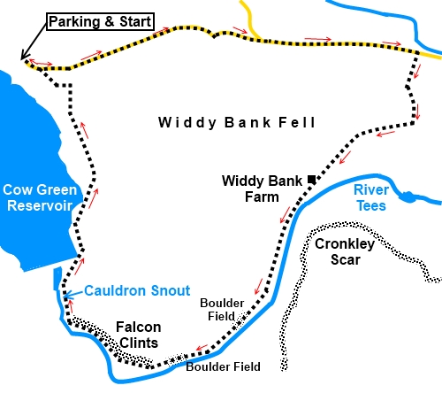
Start:
From the reservoir car park (NY 811308), walk back down the road for one
and a half miles to the road junction then turn right. Continue on the road
for just short of a mile and just after passing a white painted barn, go
over the cattle grid and turn right, following the broad track in the
direction of the public footpath fingerpost (not the bridleway) (NY847310).
A sign advises that you are entering Moor House - Upper Teesdale Nature
Reserve.
%20Cow%20Green%20reservoir.jpg)
%20Downhill%20from%20Cow%20Green%20Reservoir.jpg)
%20Viw%20over%20Teesdale.jpg)
%20Approaching%20Cronkley%20Scar.jpg)
Follow the track for a mile to Widdy Bank
Farm (NY 838298).
%20Approaching%20Widdy%20Bank%20Farm.jpg)
Go straight through the farmyard and go left
through the second set of gates.
At the next gate, you join the Pennine Way
(NY 837297). Turn right to follow the right hand bank of the river. There
are some useful rocks by the river for a picnic stop along here.
%20Along%20the%20River%20Tees.jpg)
%20Cronkley%20Scar.jpg)
%20Looking%20back%20along%20the%20river.jpg)
There is an awkward hundred yard or so
boulder field to be crossed at NY 831285 and another at NY 825281,
with a large cairn at NY 824231. Across the river, you can see the boards
which mark the army firing range area.
%20Crossing%20one%20of%20the%20boulder%20fields.jpg)
%20Cairn.jpg)
Continue to follow the riverbank as it curves
right, passing the junction of the River Tees and Maize Beck and under the
cliffs of Falcon Clints. You catch sight of Cauldron Snout quite suddenly
and may hear it before you see it.
%20Bottom%20of%20Cauldron%20Snout.jpg)
The route continues from the right hand side
of the dam. How you get there depends on what route you prefer. There is a
scramble up the rocks at the side of the waterfall, or, if you are feeling
more risk averse, you can climb up the heather covered bank – you will
discern some faint tracks this way, where others have been.
%20Upper%20part%20of%20Cauldron%20Snout.jpg)
From the right hand side of the dam, go right
to follow the service road for a mile to a gate (NY 815307). The main gate
is likely to be locked but go through the walkers’ gate alongside then
turn left on the stony track. After a couple of hundred yards, fork off to
the right on a more minor but obvious track.
At the road, turn left for the car park.
If you need to buy any
hiking equipment/clothing before your trip see the Hiking
Store
All information on this
site is given in good faith and no liability is accepted in respect of any
damage, loss or injury which might result from acting on it.
|


.jpg)
.jpg)
.jpg)