
|
|
|
To view route as a dynamic Ordnance Survey map click here. Introduction: Cross Fell in the Pennines is the highest hill in
England outside the Lake District at
2,930 feet (893 m), the highest point of the Pennines and therefore
deserves a visit. It can be rather awkward to reach, involving some lengthy
treks. This route from Kirkland is probably the shortest way. Part of the walk I rate as amber.
It is probably amber+ if not quite a red. The walking is not desperately
steep but the ascent is relentless. The descent is straightforward. Some
parts were boggy and after wet weather, you will appreciate gaiters. This was my second visit and
buoyed by a weather forecast which promised a brightening day with sunny
intervals, I had high hopes, having seen nothing on my previous visit many
years ago, due to a white-out! Sadly, history repeated itself as you can see
from the photographs, this time the views being blocked by low cloud. This
is a great pity as from the summit, I am assured there are great views
towards the Lake District, and over the Solway to Scotland. As I dropped
down below the cloud, there were tantalising, occasional glimpses of what
might have been. I should perhaps have been less
optimistic because Cross fell is renowned for hill fogs and the Helm Wind
which produces a shrieking noise. At least I did not suffer the latter! The top of Cross Fell is a broad stony plateau of limestone rock. Rock surfaces can therefore be a little slippery if wet, although most of the route is over grassy areas. The rivers Tyne, Tees and Wear start close by. The Pennine Way crosses the plateau and probably because of that, by the trig. point is an impressive and massive cross shaped shelter where, whichever way the wind is coming from, you can find a reasonable spot to have your sandwiches. I was very grateful for it! On
the outward route from Kirkland you pass the “Hanging Walls of Mark
Anthony”. I would not get too excited about this unless you are especially
interested in agricultural history as it refers to ancient cultivation
terraces. Even having Googled them before I set off, I missed them! It is very important that you have
a map and compass and knowledge of how to use them and/or have GPS
facilities, because, as I found on the day, visibility was very restricted
and in parts, the path to join the Pennine Way was not too clear. If you use
GPS and follow my route you will hit the meeting point exactly as I did, at
a flagged section with a stone flag marked with a Pennine Way sign (see
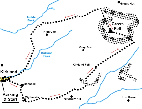
photo). The walk starts at the church in Kirkland where there are a couple of mown verge areas where you can park, plus a seat for boot changing. To get there, turn north east off the A66, at a roundabout at Penrith, on to the A686. Go straight through Langwathby, under the railway bridge and take next turn right on to a minor road, signed for Skirwith and Kirkland. In the centre of Skirwith, keep straight ahead for Kirkland and you will reach the church, on the outskirts of Kirkland. Start: With your back to the church (NY 645326), turn left along the road. At the road junction, turn left again.
Just before the last house on the right, in the main body of the village, turn right on to a tarmac drive, following the “Public Way” fingerpost (NY 648325). This fingerpost is on the opposite side of the road and was obscured by trees when I did the walk. You go through a large metal gate and a give way triangle is painted on the tarmac.
Continue along the drive to a farm and straight through the farmyard. At the far side of the farmyard, go through a gate and turn right along another tarmac lane (NY 654322). At the next farmhouse, go through a gate, more or less straight ahead and then head left to follow the blue bridleway arrow. As you get to the far side of the next field, turn left, without going through the next gate. The track on the ground is fairly obvious. The next turn is easy to miss, as you can get sucked in to following the obvious track straight ahead. The track does actually fork and you want the right fork. The best way I can describe to avoid missing the turn is to look out for a slight valley on the right. As you get to the end of the valley, turn right to ford a small stream (NY 661318). Follow the path to the left of the delightfully named Grumply Hill. See photograph.
There is now only one path, easy to follow until you reach the Pennine Way – or at least it mostly is! The path meanders a little through Wildboar Scar, where it is pretty clear on the ground but then sets a pretty steady course of between 53° and 57° magnetic, where in places it becomes less clear. It may well be crystal clear in clear weather of course. As long as you continue in this approximate direction, you are bound to hit the Pennine Way at some point which should be obvious due to the level of use. On reaching the Pennine Way, turn left. Thanks to my GPS, my navigation was spot on and I hit the Pennine Way at the direction marker shown in the photo. Wherever you hit it, turn left along it.
Climb up on to the plateau, crossing a large and awkward stone field. There are two stone pillars at NY 694341 and NY 690343 respectively to guide you, which you can probably see from some way off on a clear day. I did not see them until I was within a few yards.
Once you crest the edge of the plateau, the route on the ground is pretty clear at 288° magnetic. Arrive at the trig. point and shelter (NY 687343).
From the trig. point, follow the Pennine Way NW (338° magnetic). The path is marked with an assortment of cairns.
At a ‘T’ junction of paths, where there is a large stone cairn, the Pennine Way turns right but you turn left.
The path (bridleway) is now clear on the ground and marked by various cairns. You pass to the left of a small, broad valley with Ardale Beck flowing along it and with stone crags which I thought reminiscent of a small scale High Cup Nick.
The path leads directly to the end of the main street through Kirkland. If you need to buy any hiking equipment/clothing before your trip see the Hiking Store All information on this site is given in good faith and no liability is accepted in respect of any damage, loss or injury which might result from acting on it.
| | |||||||||||||||||

.jpg)
.jpg)
.jpg)
%20St%20Lawrences%20Church,%20Kirkland.jpg)
%20Kirkland%20Fell.jpg)
%20Path%20left%20of%20Grumply%20Hill.jpg)
%20Flag%20marked%20with%20Pennine%20Way%20sign.jpg)
%20Flagged%20path%20to%20plateau.jpg)
%20First%20stone%20pillar%20referred%20to%20in%20text.jpg)
%20Trig%20Point%20on%20Cross%20fell.jpg)
%20Shelter%20on%20Cross%20fell.jpg)
%20Hints%20of%20the%20view%20north%20on%20the%20descent.jpg)
%20Leaving%20the%20Pennine%20Way.JPG)
%20Cross%20Fell%20appearing%20throught%20the%20murk.jpg)
%20View%20over%20the%20Eden%20Valley.jpg)
%20Mini%20High%20Cup%20Nick.jpg)
%20Looking%20along%20Ardale%20Beck.jpg)