
|
|
|
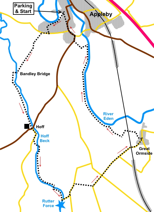
To view route as a dynamic Ordnance Survey map click here. Introduction: I call this walk from Appleby-in-Westmorland the Two Rivers walk but strictly, the first of these is Hoff Beck. When does a beck become a river? No idea but I have seen smaller rivers! Along this section of the walk, you see Rutter Force, a spectacular, horseshoe shaped waterfall, alongside which is an old sandstone mill building with a restored waterwheel, dating back to the 16th Century and now holiday accommodation. At one time, it generated electricity for Great Asby village, about a mile and a half due south. The return leg follows the course of the River Eden. The walk can be extremely muddy in places and gaiters are strongly recommended in the absence of a prolonged dry spell. The walk starts from the main Broad Close pay and display car park in the centre of Appleby. It is clearly signposted. Just follow the ‘P’ signs. Appleby is to the south of the main A66, about twelve miles east of Penrith. Start: From the main pay and display Broad Close car park in Appleby (NY 683203), turn right along the road (Chapel St.). At the junction (with Holme St.), go straight across and along Banks Lane, following the footpath sign for “Bandley Bridge”. Continue on the footpath which continues from Banks Lane. This takes you high above the River Eden. The path divides at a children’s playground. Take the left fork. The path opens into a residential street of bungalows. Turn left and at the ‘T’ junction, turn right along the pavement. This soon rises to an elevated level above the road. As it descends back to the road at the junction with Barrowmoor Road, take the track across the road indicated by the fingerpost for “Bandley Bridge” (NY 678198). This track is initially hedged. At the end of the hedged section, go over a stile next to a gate and turn left (NY 676196). Head for the diagonally opposite corner of the field. Here you will find a blue bridleway arrow indicating your onward route along the left hand boundary of the next field. At the bottom of the field, go through a gate bearing a plaque for “Rachel’s Wood”. At the time of writing (2016) this is a relatively new plantation and the well walked path was easy to follow on the ground. At the end of Rachel’s Wood, cross a stile then Bandley Bridge (footbridge) and turn left to follow the right hand bank of Hoff Beck and indicated by a blue bridleway arrow. You simply now follow this path along the route of the beck to the hamlet of Hoff. The only thing to watch out for is a split in the path at NY 671188, marked by a post, where the bridleway branches right. Keep left following the yellow arrow.
You arrive at a farmyard at Hoff. Go through the gate, then left through another gate, to exit into the road next to the New Inn. Continue straight across the road following the road sign for “Oakbeck½ mile and Drybeck 1¾ miles”. Follow this road for about three hundred yards, round a right hand bend, then take a footpath off to the left, indicated by a fingerpost for “Rutter Force 1 mile” (NY 676173). Follow a short broad track, then through a gate, follow the left hand boundary to a footbridge (NY 677171). Cross it and turn right to follow the left hand boundary of the stream. Ignore the first bridge you come to (NY 677166). Follow the bank of the beck until just before reaching a plantation, you arrive at a footbridge (NY 681162). Cross and turn left to follow the opposite bank. You will get to a stile where above to the right is a white house. Once over the stile, the path bends right towards the left of house, actually emerging on its drive. Turn left here and you are at Rutter Force.
Cross the footbridge in front of Rutter Force (NY 682159) and continue up the road. At the ‘T’ junction, turn left along the road for less than a quarter of a mile. Take a footpath on the right indicated by a public footpath fingerpost for “Donkey’s Nest” (NY 685162). Follow the right hand field boundary. There are good views along here of the distant fells including Murton Pike, High Cup Nick, Cross Fell etc.
At the top of the field, cross a stile and bear slightly left at about 45° and cross a stile by the gate into the road. Turn left. At the cross roads, keep straight ahead and follow the road into Great Ormside. As you come into the village, there is a phone box (now given over to housing a defribulator) and a bench for a potential picnic stop. Continue along the road on which you entered the village and not far past the bench, turn left on to a footpath indicated by a public footpath fingerpost (NY 701173). The path is well marked with yellow arrows. Follow it to a broad track and turn left. When the track divides, keep left. The track passes under the railway line (NY 698175). Immediately after the railway line, keep straight ahead over a concrete ladder stile. The route then curves left, under the power lines. Cross a footbridge over a beck, then fork right at the other side, climbing slightly. You soon start to get glimpses of the River Eden through the trees on the right and after descending some rough steps, you arrive at the riverbank. Turn left to follow the bank all the way to Appleby.
Just before Appleby, after crossing a large field, you get to a fence with two stiles. The right hand one is dilapidated. Tale the left stile, marked with a yellow arrow. On reaching the lane at Appleby, turn left and right at the road junction.
Opposite the road name sign “Shaws Wiend”, fork left following the parking sign. At the next junction, turn left, then right, back to the car park. If you need to buy any hiking equipment/clothing before your trip see the Hiking Store All information on this site is given in good faith and no liability is accepted in respect of any damage, loss or injury which might result from acting on it.
| | |||||||||||||||

.jpg)
.jpg)
.jpg)
%20Hoff%20Beck%20from%20Bandley%20Bridge.jpg)
%20Start%20of%20autumb%20on%20Hoff%20Beck.jpg)
%20More%20autumn%20colours%20Hoff%20Beck.jpg)
%20Ford%20and%20footbridge%20at%20Rutter%20Force.jpg)
%20Rutter%20Force%20and%20mill.jpg)
%20View%20to%20the%20fells.jpg)
%20Reflections%20on%20the%20River%20Eden.jpg)
%20River%20Eden.jpg)
%20Arriving%20at%20Appleby.jpg)