|
Settle
to Catrigg Force
Starting point and OS Grid reference: 
Settle SD 820634 – Large pay and display cp.
|
Ordnance Survey Map
OL2
Yorkshire Dales Southern and Western Areas.
Buy
this map from
List
of OS Maps
Note: If you use OS Maps on-line, you can download this route via this
link.
| |
Distance: 10 miles
|
Date of Walk: 6 November 2014
| |
Ascent:
Descent:
See Walking Time Calculator
|
1745ft (532m)
1741ft (531m)
| |
Traffic
light rating: 

(For explanation see My
Walks page)
| |


For advice on .gpx files see
My Walks page
|

Click
the PDF logo above to give a printable version of this walk without the
photos.
|
To
view route as a dynamic Ordnance Survey map click here.
Introduction:
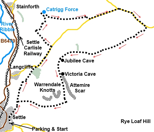
This is a lovely, easy to follow walk
from Settle which shows off some magnificent limestone scenery, the
impressive waterfall Catrigg Force and the large Victoria Cave. It is very
similar to my Settle Round but adds the waterfall which is especially
impressive after heavy rain.
This walk starts from the large car park in
Settle (SD 820634). To find this, turn east off the B6480 in the centre of
Settle along Chapel Street. At the little crossroads, turn right along the
narrow road Chapel Square which leads to the pay and display car park.
Charges are modest and there are handy benches to put on boots.
Start:
Walk back along Chapel Square, straight across the small cross roads
along High Street then turn right up Castle Hill which joins Constitution
Hill (before becoming "Highway").
Watch out for the fork at a telegraph pole. Highway branches left and you
want the broad track on the right (SD 822638).
Follow this track as it gently climbs and
there are some magnificent views back over Settle. Follow this track for
half a mile towards Langcliffe, ignoring the first track you come to on the
right (SD 823641) which climbs steeply and will be your return route.
%20View%20towards%20Stainforth.jpg)
%20View%20towards%20Penyghent.jpg)
You will soon have good views of Pen-y-ghent
straight ahead.
At the next fork (SD 824646) bear right. This
junction is easy to miss as the better used track descends to Langcliffe. As
a guide to where to branch off, look out for a group of trees on the left
with a barn in front and branch just after the barn.
You need to be climbing towards a copse of trees. Pass through the
trees and follow the path
alongside a second group of trees coming out on to a road at SD 830653.
Walk straight ahead along the road for half a
mile and after crossing a cattle grid, turn left following the Pennine Way
bridleway fingerpost for Stainforth 13/4 miles down a
tarmac track (SD 835660). Continue to a farm where you turn right,
continuing to follow the sign for Stainforth.
Follow the left hand wall of the field until
the path opens out into a much larger area where the track meets another.
Turn left. This goes to a gate in the left corner of the field (SD 832670).
Through this and a second gate, you access the Catrigg Foss waterfall. Return
through these gates
afterwards and turn left.
%20Catrigg%20Force%202.jpg)
%20Catrigg%20Force.jpg)
Follow the wall on the left then
branch off right at a fingerpost at a ladder-stile for “Henside Road 11/2
miles”. Follow the direction of the fingerpost over the hill. On reaching
the wall, turn left and follow it to the ladder-stile.
After crossing the ladder-stile, the path is
a little indistinct but head to the left of the dilapidated barn where there
is a gated ladder-stile. Cross this and head to the road, just over 100
yards to the right.
At the road, turn left (SD 848669). You now
have about 1.3 miles of road walking but this is a quiet lane with good
views across to Pen-y-Ghent and you will not meet much traffic. Ignore the
left turn on a bend.
As you arrive at a farmstead (Capon Hall)
with Malham Tarn in the distance behind it, take the path on the right
indicated by a fingerpost for “Langcliffe 3 miles” (SD 866667). The path
curves clockwise from the road to a ladder-stile, passing under some power
lines.
The path is reasonably distinct and from the
ladder-stile and keeps pretty much straight ahead until it joins a broad
track. It crests a rise where there are some rocks with
great views which make an agreeable lunch stop. The track bends to the left here and a few yards off the bend to the left is Jubilee cave.
Not far after the bend, take the path on the
left signposted for Victoria Cave (SD
837653). This is just off to the left of the main path. A notice board warns
you that the mouth of the cave is unsafe and describes some of its history.
Prehistoric remains were found there and it gets its name from the fact that
an inner chamber was discovered on Queen Victoria's accession day in 1837.
%20Victoria%20Cave.jpg)
The path descends passing below Attemire Scar
where there is a cave should you wish to climb the steep path to it. It is
an interesting cave with a pool but to explore, you need a torch and a
potholing inclination!
Turn right at a broad gateway (SD 840642) and
stay on the track below the Warrendale Knotts for a mile. You rejoin the
broad track where you began. Turn left back to the junction with Highway (SD
823641) and the road back into Settle.
%20Warrendale%20Knotts.jpg)
%20Approaching%20Settle.jpg)
If you need to buy any
hiking equipment/clothing before your trip see the Hiking
Store
All information on this
site is given in good faith and no liability is accepted in respect of any
damage, loss or injury which might result from acting on it.
|


.jpg)
.jpg)
.jpg)