
|
|
|
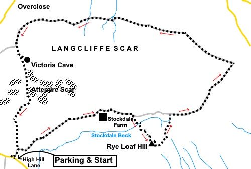
To view route as a dynamic Ordnance Survey map click here. Introduction: There is overlap on this walk with my Settle Round walk, which I did in 2010. For whatever reason, I did not include Rye Loaf Hill at the time but conscious of an unreached trig. point, I vowed one day to rectify the omission and this was it! This walk goes in the opposite direction to the Settle Round. It is mostly a very easy walk but the section up Rye Loaf Hill is steep and awkward. Not quite a ‘red’ hence an amber rating. The walk includes views of some of the best limestone scenery in the Yorkshire Dales. Additionally, because the summit of Rye Loaf Hill at 1795ft (547 metres) is relatively compact, you get a great 360° view from it, including all three of the Yorkshire Three Peaks, Ingleborough, Whernside and Pen-y-ghent. There is a somewhat pathetic shelter at the top but it helps a little with the wind. Rye Loaf Hill has no Rights of Way denoted but as it is Access Land, you are free to wander. On the remainder of the circuit, you get spectacular limestone scenery, a good view of Malham Tarn, all of the Three Peaks and you can also visit Victoria Cave. I did not visit on this occasion having seen it before but more information is contained in my Settle Round walk. Some curiosities you pass on the final part of the walk are some large, cast iron sheets, below Attemire Scar/Warrendale Knotts. These bear the inscription “Woods Target 1860”and “T. Richardson & Co in London”. In 1854, in response to threats of war with France, a volunteer rifle corps was set up and the Attermire Range was established in 1860 for them to practice. These were their targets (or maybe backing to the targets?). Judging from some of the holes, they had some pretty impressive weapons! The corps was transferred to the Territorial Army in 1908 and the range was used until the First World War. The walk starts from some rough, roadside parking by some sheep pens on High Hill Lane (marked on the OS map) (SD 836630). To get there, take the road to Airton off the A65 at Coniston Cold, signposted for Bell Busk and Malham. In Airton, turn left for Settle. At the next road junction, turn left. A quarter of a mile after crossing a narrow bridge with low parapets, you arrive at the sheep pens. There is a wide track off to the right immediately after them, with a fingerpost for “Pennine Bridleway” and “Stockdale Lane”, where the walk starts. Do not block the gates to the sheep pens and leave a reasonable manoeuvring space for the farmer’s vehicles! Start: With your back to the sheep pens at the parking area, turn right and immediately right again following the fingerpost for “Pennine Bridleway” and “Stockdale Lane”.
After about one and a quarter miles, when you get to the entrance to Stockdale Farm, which has a prominent sign, go through the left gate following the fingerpost for “Malham”. Around a third of a mile later, go through another gate. The main track becomes slightly elevated. Keep a look out below you on the right for another gate (SD 861638). Through this gate, you begin the ascent of Rye Loaf Hill. Initially but for only about a hundred and fifty yards, follow the wall on the right. You get too a small but steep valley, with a stream. There are signs of paths of to the right, following the wall but if these do eventually take you up the hill, I think they will be a long way round. Also, looking at the summit, it looks much steeper to the right. I opted to go left for less than a hundred yards where I found a suitable spot to cross the valley and stream. After that, I zig-zagged, to even out the slope a little. If you are using GPS, my route follows the zig-zag path I took.
Keep a look out for this construction at SD 863634, probably something to do with water.
Aim for one of your zig-zags to pass in front of this and from there, the climb to the summit is not too bad.
From the summit (SD 864633), head left, in relation to the direction in which you arrived, for fifty/sixty yards. There is then an easy route to the wall to the south, joining it at about SD 865633. Follow this wall down. It meets the track you left to climb the hill. Turn right along it. You could descend directly from the summit across to the track but this looks like it would be hard work and the route by the wall is relatively easy.
Follow the clear track to a junction where there is a three way fingerpost. Turn left following “Pennine Bridleway” and “Langscar Gate 1¼” (SD 875640). On the way to this point is some exposed limestone, which could provide a picnic spot. Continue to another three way fingerpost and turn left to follow “Pennine Bridleway” and “Langcliffe 4¼ miles” (SD 881649).
Keep following the very clear track, ignoring any turns off until you reach a fingerpost for “Victoria Cave ¼ mile” (SD 837653). Turn left here. After about three hundred yards, there is a path climbing to the left. Take this path if you want to visit Victoria Cave. It is not very far. Otherwise continue down the path. The path descends to the left of a wall, to reveal impressive limestone scenery. Follow it down to more level ground and turn right through a wide gateway. It is along here where you will see the cast iron sheets referred to in the introduction.
Just past the metal sheets, turn left over a stile to follow the fingerpost for “High Mill Lane 1 mile” (SD 838641). Follow the obvious path until you reach another stile on the left, where there is a two way fingerpost. Cross the stile and turn right to return to the parking area. If you need to buy any hiking equipment/clothing before your trip see the Hiking Store All information on this site is given in good faith and no liability is accepted in respect of any damage, loss or injury which might result from acting on it.
|
| |||||||||||||||||

.jpg)
.jpg)
.jpg)
%20Warrendale%20Knotts%20and%20Attemire%20Scar.jpg)
%20Summit%20of%20Rye%20Loaf%20Hill.jpg)
%20Aiming%20point.jpg)
%20View%20south%20at%20Rye%20Loaf%20Summit.jpg)
%20View%20at%20Rye%20Loaf%20Summit%20towards%20Pen%20y%20ghent.jpg)
%20Looking%20back%20to%20Rye%20Loaf%20Hill.jpg)
%20View%20west%20during%20descent.jpg)
%20Malham%20Tarn.jpg)
%20View%20to%20Ingleborough.jpg)
%20Pen-y-ghent.jpg)
%20Panorama%20showing%20all%20the%203%20peaks.jpg)
%20Warrendale%20Knotts.jpg)