
|
|
|
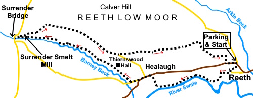
To view route as a dynamic Ordnance Survey map click here. Introduction: This walk goes from the lovely village of Reeth in Swaledale to Surrender Bridge and visits the ruin of the Surrender Smelt Mill. Along the way are some beautiful views which show Swaledale at its best. Why
‘Surrender’? The folklore explanation is that there were legal problems
between different factions/companies and that one eventually
‘surrendered’. A more likely explanation is that it is named after
Surrender Moss, just over a mile away on the moor. In this context
‘Surrender’ is thought to stem from the morphing through local dialects
of Old Norse sūran, meaning sour, peaty or damp and Old English
aerghi meaning hill pasture. Both are apt in connection with this land. Reeth
is the largest settlement in Upper Swaledale. It has always been a centre
for farming and was noted in the Domesday Book but it grew in the 18th
Century when coal and lead mining developed. Indeed, a look at the Ordnance
Survey maps for the area reveals extensive evidence of mining. By the 19th
Century, the Reeth area was producing 10% of the entire country’s lead.
The current Surrender Smelt Mill structure was built in 1839 on the site of
two earlier mills and closed in 1880, when cheaper imports destroyed
Britain’s lead mining industry. A swing bridge over the river Swale was built in 1920. The Swale is one of the fastest rising rivers in England, said to be able to rise three metres in twenty minutes. The current swing bridge was built in 2002 after the 1920 bridge was smashed by an uprooted tree in floods in 2000. Overall the walk is relatively easy but I award an amber traffic light for a section after Healaugh for two reasons. Firstly, on the day I did the walk, there was a section badly obscured by bracken. This will obviously depend on the time of year but shortly after that is a section which follows a very narrow if short length of footpath on the south side of a wall. This path is above an extremely steep banking which goes a long way down. It needs care and I certainly would not recommend doing it when icy or after heavy rain when it might be slippery. Secondly, at the end of this section, there is a short but steep ascent from a stream. This walk starts in the centre of Reeth where there is parking on the village green (SE 038993). Note, market day is on Friday when it will be much busier with reduced parking. There are public toilets here. Reeth is the main town in Swaledale on the B6270. Start: From the green/market place (SE 038993) head downhill passing in front of the Kings Arms and Black Bull Hotel.
At the bottom of the street, you reach Anvil Square. At the rear of the square, turn right and follow the footpath sign ‘To the River’ passing The Old Smithy. You arrive in a residential street (Langhorne Drive). Turn left and at the end of the street turn right along a narrow walled lane with ‘cul de sac’ and playground signs. The tarmac becomes a stony track. Follow it until you reach a fingerpost where you turn left for the Swing Bridge.
At the river, do not cross the bridge but turn right to follow the right riverbank for three quarters of a mile, ignoring another path at SE 029991after only a quarter of a mile. At a four way fingerpost, turn right following the finger for the Coast to Coast path. This will take you to the road at Healaugh where you turn left.
Follow the road to just beyond the end of the village and turn right up a narrow lane by a bench following the road sign for ‘Kearton 1 Mile’ (SE 017990). After just over a hundred yards, turn right up a track for Thiernswood Hall. The sign by the entrance indicates ‘Private Land’ but it is a Right of Way. Follow the track past the hall, through a heavy metal gate then another gate on to the moorland. Follow the stone wall on the left and as it curves right, go through a stile in the wall (SE 009994). The onward path was difficult to follow here because of copious amounts of bracken. If you are not following my GPS route and the path is unclear, I suggest using a compass and aiming just north of west until you reach a stone wall on the left. This should be at about SE 008993. Turn right to follow it. In parts, users have taken a route slightly away from the wall so take the line of least resistance but keep it in sight. Follow the wall for just under half a mile keeping a look out for a walkers’ gate (SE 001997). Go through the gate and turn right to follow its other side. You need to be extremely careful along here as there is a steep drop to the left and the path is very narrow.
At SD
996999, you drop down to a stream and the path rises steeply directly
opposite though may not be obvious at first, depending on the vegetation. It
rises up some steps, then a steep bank. Follow the obvious path along the
edge of the valley, above Old Gang Beck or Barney Beck – I’m not sure
where the name changes, probably at Surrender Bridge. Ahead in the near distance you may see some cars parked and this is the location of Surrender Bridge.
Follow the path by Surrender Lead Smelt Mill where a sign indicates it is a Scheduled Ancient Monument.
Follow the path to the road, then turn right along it for a few yards before turning right again across the moor, following a fingerpost for ‘Coast to Coast Path’.
After descending some stone steps, cross a footbridge (NY 995 002). You will come to a split in the path where the right fork is marked with a yellow arrow. Turn left to follow a blue bridleway arrow (SE 004999). You will soon come to another junction with a gravel track going left. Go right here to join a broad gravel track below you at SE 010996 and then turn left along it. As the gravel becomes tarmac, at a three way fingerpost, turn left following the sign for the ‘Coast to Coast’ path (SE 012995).
Follow this track until just above a large farm, it turns sharply left. You keep straight ahead again following a fingerpost for the ‘Coast to Coast’ path (SE 029998). You now stay on this well defined path emerging on the road on the outskirts of Reeth. Turn left to return to the parking area.
If you need to buy any hiking equipment/clothing before your trip see the Hiking Store All information on this site is given in good faith and no liability is accepted in respect of any damage, loss or injury which might result from acting on it.
| | |||||||||||||||||
.jpg)
.jpg)

.jpg)
.jpg)
.jpg)


%20Centre%20of%20Reeth.jpg)
%20Reeth%20Swing%20Bridge.jpg)
%20View%20North%20from%20the%20riverside.jpg)
%20View%20over%20the%20Swale%20to%20Highg%20Harker%20Hill.jpg)
%20Looking%20along%20the%20River%20Swale.jpg)
%20Centre%20of%20Helaugh.jpg)
%20Barney%20Beck.jpg)
%20Approaching%20Surrender%20Smelt%20Mill.jpg)
%20Surrender%20Bridge.jpg)
%20View%20along%20Swaledale%20with%20Calver%20Hill%20to%20the%20left..jpg)
%20Track%20across%20the%20moor.jpg)
%20View%20near%20SE%20012995.jpg)
%20Swaledale.jpg)
%20Swaledale.jpg)
%20Approaching%20Reeth.jpg)