|
Middleham
to Aysgarth
Starting point and OS Grid reference: 
Middleham
Castle – Free parking Main Street/market square, Middleham (SE127876).
|
Ordnance Survey Map
OL30
Yorkshire Dales – Northern and Central Areas.
Buy
this map from
List
of OS Maps
Note: If you use OS Maps on-line, you can download this route via this
link.
| |
Distance: 10.5 miles
|
Date of Walk: 10 May 2012
| |
Ascent:
Descent:
See Walking Time Calculator
|
1893ft (577m)
1626ft (495m)
| |
Traffic
light rating: 
(For explanation see My
Walks page)
| |


For advice on .gpx files see
My Walks page
|

Click
the PDF logo above to give a printable version of this walk without the
photos.
|
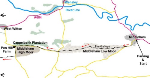
Note - because this is a linear
walk, to maintain legibility, the map is split into two and would join at
the bold black arrows
To
view route as a dynamic Ordnance Survey map click here.
%20Market%20cross%20Middleham.jpg) Introduction:
This
is a linear walk from Middleham to Aysgarth so you need to work out
tactics for the return journey by car/bus. It is possible to return via the
river footpath but this would make the walk somewhat long. At the time of
writing, buses do connect Middleham and Aysgarth. Introduction:
This
is a linear walk from Middleham to Aysgarth so you need to work out
tactics for the return journey by car/bus. It is possible to return via the
river footpath but this would make the walk somewhat long. At the time of
writing, buses do connect Middleham and Aysgarth.
There is some road walking, mostly on quiet
lanes where you are more likely to meet horses than traffic but there is one
brief stretch along the A684 - less than ½ mile and there are narrow grass
verges.
This is a varied walk, starting in the pretty
Dales village of Middleham, takes in Penhill, which at 526 metres provides
good views of Wensleydale and passes attractive waterfalls along the River
Ure, including the famous Aysgarth Falls.
Middleham is the centre of racehorse country
and is famous for its massive castle, greatly out of proportion to the
relatively small village. It has an attractive cobbled centre and Georgian
houses and cars can be parked free in the market square and on the main
street. Public toilets and a selection of cafes/pubs are available both at
Middleham and at Aysgarth. This walk finishes at the George and Dragon in
Aysgarth.
As a common point of reference, the walk
starts at the entrance to the castle.
Start:
Facing the castle entrance (SE127876), turn left and walk up the track.
Look out for a gap stile on the right with a gate and go through this. Cross
the field behind the castle bearing slightly right, towards the end of the
row of cottages. The path then swings left to follow the high stone wall.
%20Middleham%20Castle.jpg)
Go through a narrow slit stile and walk along
the edge of the road for a few yards (SE 122874). Go through the gateway
across the road which leads on to Middleham Low Moor and the Gallops and
turn left.
%20Trig%20point%20on%20Middleham%20Low%20Moor.jpg)
Head towards the highest point and when you
get to the horse track, cross it and follow its left hand side. As you reach
the end of the horse track, you will see the trig. point (SE 105874). From
this, bear slightly left and walk more or less along the centre of the Moor.
Eventually the track to follow becomes more distinctive.
On reaching a broad stony track (SE 093872)
turn right and after 50 yards or so, turn off left on to a grassy track.
There was a post with a dilapidated white marker on it when I did this walk.
Follow the track to a road junction (SE
089872) and go straight ahead on the road – Common Lane (i.e. do not go
left or right). Walk along this quiet road for just over 1¼ miles and at
the junction by Penhill Farm (SE 068875), turn left for Melmerby. After
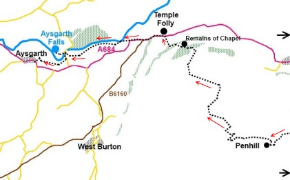
5/600 yards, turn right on to the bridleway for Penhill (SE 067869).
%20Penhill.jpg)
The path is obvious and goes through several
gates, passing to the right of a pond. On reaching the base of Penhill, the
steep route to the top and the huge “drystone wall” style cairn is clear
(SE 056867). It is not very long but if you want to even out a little of the
gradient, take the broad grassy track to the left and go right to follow a
dilapidated wall to the top.
%20Stone%20cairn%20on%20Penhill.jpg)
%20Along%20the%20edge%20of%20Penhill.jpg)
From the cairn, take the broad track which
continues beyond it bearing slightly right, to the edge of the plateau, and
go left along the edge (SE 046867). This path is not shown on the Ordnance
Survey map but is clear on the ground. Follow the edge of the plateau, until
you reach a broad track going down to the right, initially doubling back on
yourself.
Follow the track downhill until you almost
get to the old quarry where you turn left (SE 048868). There are what look
like some very low drystone walling at this point.
Continue descending until you reach another
path and turn left. Follow this until it reaches a stone wall at a broad
track and turn left. This track goes right through a gate.
Pass a two way finger post confirming the
public footpath. Go through a gated stile and continue on the obvious track.
At a junction of broad tracks through a gate (SE 045879), turn left. The
track soon becomes a walled lane.
After just short of half a mile, at a gateway
where there is a large rectangular boulder, turn right on to another walled
track (SE 038882). At a sharp bend in the track, take the left turn
following the finger post for Templar Farm 1½ miles. After passing between
two copses of trees, the path opens up into a large field. Head towards the
bottom right hand corner, passing to the left of the ruins of the Knights
Templars’ Penhill Preceptory, (fenced) (SE036888).
%20Temple%20Folly.jpg)
Go through the walkers’ gate in the corner
following the sign for Templar Farm along the downhill stony track. Pass the
farm and at the main road opposite the Temple Folly (SE 033980), turn left
along the A684. Care is needed here as it is quite a busy road but there are
narrow grass verges and you only remain on it for half a mile.
%20Typical%20Wensledale%20View.jpg)
Pass the turn for West Burton and an AA box,
cross the river bridge, then turn off the road to the right through a small
walkers gate by the public footpath fingerpost (SE 025889). The path leads
down to the river where you go left to follow the bank. There are some
impressive waterfalls along this stretch.
On arriving at St Andrew’s Church at
Aysgarth, it is worth a look inside at the intricately carved 16th
century screen which came from Jervaulx Abbey.
%20Aysgarth%20Falls.jpg)
Walk down the left hand side of the church to
the river, cross the river bridge and take the footpath immediately on the
left to visit the famous Aysgarth Falls. Return then to the bridge and walk
up the hill for about 150 yards before turning right in the direction of the
fingerpost for “ Aysgath Village ½ mile” (SE 011885).
If you need to buy any
hiking equipment/clothing before your trip see the Hiking
Store
All information on this
site is given in good faith and no liability is accepted in respect of any
damage, loss or injury which might result from acting on it.
|


.jpg)
.jpg)
.jpg)