|
Linton
and Kilnsey
Circular
Starting point and OS Grid reference:

Fountaine
Inn at Linton (SD 997628) – on street parking
|
Ordnance Survey Map
OL2
Yorkshire dales – Southern and Western Areas.
Buy
this map from
List
of OS Maps
Note: If you use OS Maps on-line, you can download this route via this
link.
| |
Distance: 11.3
miles
|
Date of Walk: 19 October 2011
| |
Ascent:
Descent:
See Walking Time Calculator
|
1459ft (445m)
1458ft (444m)
| |
Traffic
light rating: 
(For explanation see My
Walks page)
| |


For advice on .gpx files see
My Walks page
|

Click
the PDF logo above to give a printable version of this walk without the
photos.
|
To
view route as a dynamic Ordnance Survey map click here.
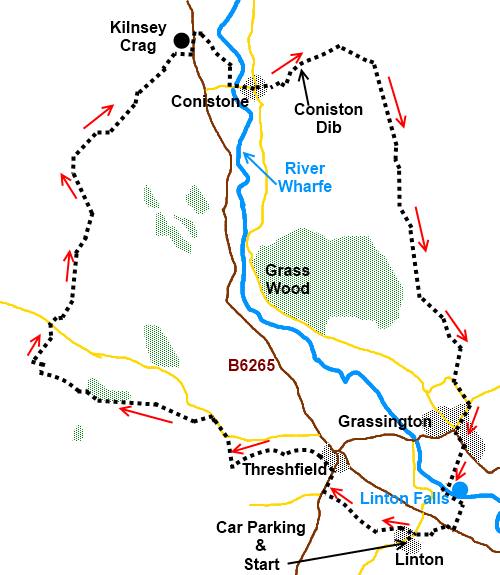
Introduction:
This is an easy walk but one which
takes in some fine limestone scenery including the famous Kilnsey Crag, the
limestone gorge at Conistone Dib, the village of Grassington and Linton
Falls. It is a good walk for anyone coming to the Dales for the first time.
Refreshments are available
at the Tenants Arms or Kilnsey Park (trout farm) at Kilnsey, various places
in Grassington and the Fountaine Inn in Linton. There are public toilets in
Grassington car park.
There is very little
significant gradient on this walk.
The walk starts from the
pretty hamlet of Linton outside the Fountaine Inn. There is street parking
but it does tend to get busy so get here early at peak times. An alternative
is to use the large public pay and display car park in Grassington through
which the route passes anyway.
To get to Linton, turn
north east off the B6265 between Threshfield and Cracoe signposted Linton.
%20Fountaine%20Inn%20Linton.JPG)
%20Linton%20Bridge.jpg)
Start:
With your back to the Fountain Inn facing the green (SD 997628), turn left
then turn right along the road. Just before the road bridge over the river, turn left
on to the footpath.
The path forks at a gate
with a two way fingerpost (SD 994629). Take the left fork signed B6265 and
Threshfield. Go over the stone footbridge over the disused railway line,
bear right to the end of the copse of trees and follow the wall along on
your left.
On reaching the road (the
B6265) (SD 998624), turn right but take care as this is a busy road with no
pavement. You are not on the road for long. Pass the Old Hall Inn and turn
left immediately after it on a broad drive (SD 990636) in the direction of
the fingerpost for Skirethorns.
After 20 or 30 yards on the
drive, branch off to the right indicated by a fingerpost over a stone stile.
Turn right over another stile and head diagonally across the field heading
for the corner of a wall then follow the wall keeping it on your left.
Go over a stone stile you
come to on the left and follow the wall along to a three way fingerpost and
go over the stone step stile in the direction indicated for Skirethorns
lane.
Turn left over the next
stile then go straight across the field to another gated stile at the end of
the stone wall – do not confuse this with the stile in the opposite
corner.
Go straight across the farm
drive (SD 982637) to another gated step stile in the wall opposite. Bear
left and go to the top of the banking by the old stone barn and turn left.
Follow the wall along and go through the gated stile at the end where there
is a yellow footpath arrow. Go through another gated stile on to the tarmac
lane and turn right (SD 979636).
At the corner, go straight
ahead in the direction of the fingerpost for Mastiles lane. Turn left into
Wood Nook caravan site (SD 977641) where there is a fingerpost indicating
Bordley.
Go through the caravan site
on the main drive and bear left following the direction of the public
footpath fingerpost as it goes through one of the caravan fields. The exit
is in the left hand corner via a stile and stream in the direction of the
fingerpost.
%20Height%20House.jpg)
This next section of the
route is marked by yellow topped posts. You pass the old disused farmhouse
Height House at SD 963644 and shortly afterwards, go right through a walkers
gate (SD 959645) in the direction of the footpath fingerpost down to the
barn (Height Laithe). Just past this, go left through a kissing gate and
follow the wall on the left to another fingerpost you can see on the horizon
(SD958646). Turn right for Kilnsey and follow the path to the road (Malham
Moor Lane).
At the road go straight
across again for Kilnsey. Your route is now indicated by blue topped posts.
When they peter out, follow the obvious track. It becomes a walled lane.
After going through a
series of gates (for corralling animals), come to a broad gravel track and
turn right (SD 965670). This is Mastiles Lane. Follow this all the way down
to Kilnsey. As it joins a tarmac track, turn right. Pass Kilnsey Old Hall
and where the road forks, go left down to the main road (B6160) by the
Tennants Arms.
%20Rear%20of%20Kilnsey%20Crag.jpg)
%20Hamlet%20of%20Kilnsey.jpg)
%20Kilnsey%20Crag.jpg)
%20Conistone%20Dib.jpg)
Turn left
and just as you come to Kilnsey Crag itself, turn right on to a
footpath signposted Conistone Bridge. Head right, across to the corner of the walls
and again to the next external wall corner (SD 979677). Turn right for the bridge.
At the bridge, turn left
along the road.into the village of Conistone. Go left at the triangle
with the maypole/weathervane and almost immediately right on to the gravel
track in front of the cottages. When it forks, go right (SD 982675).
At the gate, follow the
fingerpost for Conistone Dib. Go thorough the narrow gorge and where it
opens out a little, below the radio mast, turn right by a three fingerpost
signposted to Grassington (SD 990679).
%20Coniston%20Dib2.jpg)
Walk on the well defined
track to Grassington passing an old limekiln on the right. At a gated stone
step stile where the Dalesway arrow points left, this is your route to
Grassington. At any further forks, keep left.
Eventually, the track
becomes a walled lane which you follow into the village. When you get to the
village, turn left and at the village hall, go right down the main street.
%20Centre%20of%20Grassington.jpg)
At the bottom of the main
street, turn left then right into the car park (SE 003638). Walk across the
car park until you come to the footpath going right down to Linton Falls.
Cross the falls by the bridge and turn right then left at the old packhorse
bridge (do not cross it). On reaching the road turn left.
%20Linton%20Falls.jpg)
Watch out for a footpath on
the right (SE 003632) indicated by a sign on the side of a house stating
B6161 via Stickhaw ½ mile or Linton Camp ¼ mile. After 50 yards trun right
by the sign Linton via B6160. On reaching the road, turn right and at the
fork, go left then at the next road junction, turn left into Linton.
If you need to buy any
hiking equipment/clothing before your trip see the Hiking
Store
All information on this
site is given in good faith and no liability is accepted in respect of any
damage, loss or injury which might result from acting on it.
|


.jpg)
.jpg)
.jpg)