
|
|
|
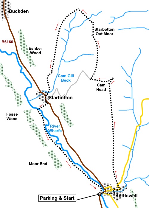
To view route as a dynamic Ordnance Survey map click here. Introduction: This walk from Kettlewell takes you up on to the fells above Starbotton and then down to Starbotton and back along the river. In my opinion, this is one of the most attractive areas of Wharfedale. This route could easily be extended to the summit of Buckden Pike. This would add about two miles to the overall distance, depending on which way you came down but having ascended Buckden Pike many times over the years, I excluded it this time. The route is very easy to follow, with distinct, well walked paths. Some sections were muddy after recent rains and I was glad of my gaiters! Kettlewell and Starbotton originated as farming communities but from the 16th century, lead mining occurred becoming more prolific in the 18th and 19th centuries, became centres for lead mining and indeed one of my reasons for picking this route was to have a look at the mining remains. These comprise remains of bell pits and spoil heaps with several mines at around five hundred metres. The deposits of lead in this area were never particularly abundant, though a smelter remained in operation at the top of Cam Gill Beck until the early 1900s Kettlewell and Starbotton suffered major flooding in 1686. Many people drowned and several houses were swept away. Looking at the steepness of Cam Gill Beck, one can imagine that a significant deluge would have quite some force by the time it reached the valley floor and Starbotton. The walk starts from the picturesque village of Kettlewell which is on the B6160 between Threshfield (near Grassington) and Wensleydale. There is a pay and display car park in the village centre with public toilets but also a private one across the road, just by the river bridge, which is half the price (pay at the garage or café). As a common reference point, the walk starts from the pay and display car park. There are various pubs/cafes for refreshments in Kettlewell and the Fox and Hounds pub in Starbotton. Start: Exit the car park and turn left. Opposite the toilets, turn right, following the road sign for the church and Scargill House (Middle Lane). Turn left at the little roundabout with seating.
Pass the Kings Head pub and follow the road as it curves left, quickly reaching the village store where you turn right to follow the road sign for Buckden and Aysgarth. At the next junction, turn left following the road sign for “Leyburn (Gradient 1 in 4)”. The road is also marked as “Unsuitable for heavy goods vehicles”. After about a hundred and fifty yards, the road bends sharply right. Branch off left here on to steep, stony track, following the fingerpost for Starbotton 3½ miles” and “Coverdale ½ miles” (SD 972725). This track is shown as “Top Mere Road” on the OS map.
Continue on Top Mere Road for just short of two miles where you meet another broad track (Starbotton Road on the map) (SD 971753). Turn left, following the fingerpost for “Starbotton” (You can shorten the walk and omit the mines section by continuing on this straightforward track to Starbotton if you wish).
After just under half a mile, you reach a gate. Just beyond this, turn right on to a bridleway, marked with blue arrows on a post (SD 965753). Follow this track to a stile by a gate. Cross this and turn left to follow the ruined wall and fence line, indicated by the fingerpost for “Walden Road 11/8 miles” (SD 966755).
The wall eventually becomes a bit more substantial. You pass a sign for “Low Walden Road”. Just after this sign, the path divides. Take the climbing path to the right. At SD 965766, you pass the old spoil heaps on the right and bell pits to the left.
Continue to follow the path. At a large cairn (SD 961771), it joins another bridleway (shown as Walden Road on the OS map). Turn left here. The track follows the right hand side top of the Cam Gill Beck valley, all the way to Starbotton. I found a few rocks to sit on for a picnic with a good view at SD 957767.
Cross the bridge and turn right to the main road, emerging next to the Fox and Hounds pub. I enjoyed an excellent pint there – well, it would have been rude not to!
Turning left at the pub, follow the road to the edge of the village and there, turn right following a fingerpost “Kettlewell 2 miles”. Cross the river via the footbridge and turn left. Cross three small fields and at the end of the third, bear away from the river at about 45° to a yellow topped post. The route from that post to Kettlewell is clear.
If you need to buy any hiking equipment/clothing before your trip see the Hiking Store All information on this site is given in good faith and no liability is accepted in respect of any damage, loss or injury which might result from acting on it.
| | |||||||||||||||||

.jpg)
.jpg)
.jpg)
%20River%20Wharfe%20at%20Kettlewell.jpg)
%20Kettlewell%20from%20Top%20Mere%20Road.jpg)
%20Looking%20across%20the%20Wharfe%20Valley%20from%20Top%20Mere%20Road.jpg)
%20View%20to%20Great%20Whernside.jpg)
%20Upper%20Wharfedale%20from%20track%20at%20Sandy%20Gate.jpg)
%20Buckden%20Pike.jpg)
%20Traces%20of%20snow%20on%20Firth%20Fell%20&%20Birks%20Fell.jpg)
%20Spoil%20Heaps%20on%20Starbotton%20Out%20Moor.jpg)
%20Cairn%20and%20Bell%20Pits.jpg)
%20Looking%20down%20Cam%20Gill%20Beck.jpg)
%20View%20over%20Cam%20Gill%20Beck%20to%20Middl;esmoor%20pasture.jpg)
%20Top%20of%20the%20Cam%20Gill%20Beck%20valley.jpg)
%20Lower%20part%20of%20Cam%20Gill%20Beck%20valley.jpg)
%20Starbotton.jpg)
%20Centre%20of%20Starbotton%20and%20Fox%20&%20Hounds.jpg)
%20Evening%20light%20on%20the%20Wharfe%20at%20Kettlewell.jpg)