
|
|
|
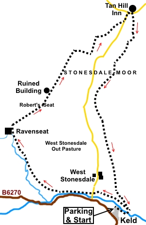
Introduction: This walk from Keld starts with great views of Keld itself and upper Swaledale before climbing via Witsundale to Robert’s Seat. From here, you cross open country which gives you a real sense of the bleakness and isolation of the North Pennines area. At the Tan Hill Inn, is the opportunity for refreshment before a shorter return to Keld, via the Pennine Way. Whilst there is a steady climb to Robert’s Seat, the walking is not difficult. I was fortunate to do the walk after a long dry spell but the nature of the ground in places and prevalence of moss, suggests that after wet weather, gaiters would be a good idea! Keld is the last and highest settlement, virtually at the far western end of Swaledale. The Pennine Way and Wainwright’s Coast to Coast walk cross here. Its name comes from the Norse word Kelda meaning spring or well. It has a number of stone buildings which are Grade II listed, including Congregational and Methodist chapels, the school and the Literary Institute. It is a peaceful and tranquil spot now but at the height of the lead mining in the area, in the middle of the 19th century was a bustling centre. Close by are spectacular waterfalls, notably Kisdon Force and Catrake Force (pictured).
To
view route as a dynamic The Tan Hill Inn dates from the 17th Century and is famous for being the highest pub in Britain at 1732ft (528m) and as the location for double glazing adverts on TV! It is an inn of great character, with exposed beams and stone flagged floors, with a real fire which is reputedly never extinguished. It offers accommodation, food and judging from the pint I had, extremely good beer. Its early prosperity was due to the presence of miners in the area but now relies on tourists and walkers. Indeed, it is many walkers’ dream to be stranded there on a snowy night, a predicament which is not unheard of, given its altitude and isolation! In extremis, they have a tracked vehicle, which sits in a predominant position outside. As stated, Keld is very isolated at the end of Swaledale, To get there, follow the B6270 west from Reeth, beyond Muker and Thwaite, or west via the B6259, then B6270 from Kirkby Stephen. There is also a cross country route from Hawes. Parking is available at a very reasonable honesty box car park in the village (signposted). Start: Exit the car park and cross straight over the road and down the stony track following the fingerpost for “Swale Trail”, “Coast to Coast” and “Public Bridleway”. After about two hundred and fifty yards, turn left at a fingerpost for “Pennine Way”, “Swale Trail” and “Public Bridleway”. This leads down an elaborately constructed path/”wheelway”, to the river.
Cross the footbridge and follow the well manicured stony path. There are good views of Keld, Upper Swaledale and to Great Shunner Fell in the distance.
You soon reach a couple of benches, where you turn left, following the fingerpost for “Pennine Way”. After about a hundred and fifty yards, go through a gate. There are a couple of stone cottages. Turn left here, following a public bridleway fingerpost (NY 895012).
Follow the obvious path for just over half a mile to join a tarmac lane. Turn right for just a few yards, then left through a gate, following the direction of the footpath sign on the gatepost. The route is clear on the ground, more or less parallel with the river below, to the left. The footpath joins a broader track (NY 877016) Turn right. After a few yards, the track divides. Keep right, following the more major track.
Arrive at the farm at Ravenseat (NY 863033). Go though the gate between the farmhouse and the barn and straight across the farmyard to cross a stile at the other side. Follow the fingerpost for “Tan Hill”. Cross the first field after the farm then go through the gate and take the right fork climbing gently. After a few yards, the path forks again and once again fork right, to follow the direction of a steam below you, in a small valley to the right. This has the unflattering name of Pryclose Gutter. The fence on your right eventually curves left and the path leads you to a stile which you cross, to climb to the top of Robert’s Seat. The path is pretty clear on the ground. Off to the left, on the way up, is a hollow where there are a number of rocks where you can sit for a picnic if you wish (NY 869040).
Continue the climb to the top. Well in advance, you should be able to spot a distinct, square, end wall, the remains of a small ruined building (NY 873045), just east of the summit of Robert’s Seat. The route is just to the right of this.
Shortly after the ruin, cross a fence line via a wooden stile and follow the path in the direction of the fingerpost.
A mile later, your way ahead is crossed by a steep sided little valley with a stream. The path turns right here to follow the top of the right hand side of the valley. Pass above a ruined, circular sheep fold (NY 883056). Cross a stream via a clapper bridge (NY 885055) and turn left, following a public footpath fingerpost. The path meets the road (NY 895064). Turn left for the Tan Hill Inn which is clearly visible.
After enjoying refreshment (or resisting the temptation), the onward route is the stony track, opposite the door of the pub and clearly marked “Pennine Way” and Keld 4¼ miles.
After just short of half a mile, branch right off the stony track, following the Pennine Way fingerpost. The Pennine Way is well marked and clear on the ground and takes you back to Keld. The only point to watch out for is a short distance after passing through a group of barns, you need to turn right off the more major track (which leads to Frith Lodge) (NY 890031), on to a grassy path. The path drops down Startindale to meet your outward path at the two stone cottages you passed early on the walk. Retrace your steps to the car park.
If you need to buy any hiking equipment/clothing before your trip see the Hiking Store All information on this site is given in good faith and no liability is accepted in respect of any damage, loss or injury which might result from acting on it.
| | |||||||||||||||||

.jpg)
.jpg)
.jpg)
%20Path%20and%20wheelway%20to%20river%20Swale.jpg)
%20Catrake%20Force.jpg)
%20Keld.jpg)
%20View%20to%20Great%20Shunner%20Fell.jpg)
%20Upper%20Swaledale.jpg)
%20Low%20Bridge%20Swaledale.jpg)
%20Reynoldson%20Syke.jpg)
%20Waterfall%20just%20before%20farm%20at%20Ravenseat.jpg)
%20View%20during%20ascent%20of%20Roberts%20Seat.jpg)
%20Ruined%20building%20on%20Roberts%20Seat.jpg)
%20True%20Bleakness%20of%20the%20North%20Pennines.jpg)
%20Tan%20Hill%20Inn.jpg)
%20Tan%20Hill%20Inn%20sign.jpg)
%20Tan%20Hill%20Inn%20Company%20Car.jpg)
%20View%20back%20to%20the%20Tan%20Hill%20Inn%20from%20Pennine%20Way.jpg)
%20Startindale.jpg)
%20View%20east%20along%20Swaledale.jpg)