
|
|
|
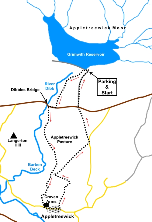
To view route as a dynamic Ordnance Survey map click here. Introduction: This walk to Appletreewick is an easy excursion with the opportunity for refreshment at one of my favourite pubs, the Craven Arms in Appletreewick. The New Inn is also available. This makes it an ideal short walk for the type of weather when you might not want an outdoor picnic. On the downside, there are a couple of potentially muddy sections early on where gaiters will be appreciated. The route broadly follows the course of Barben Beck and there are some attractive views along Wharfedale, sadly not accorded justice by the somewhat grey day when I did the walk. Grimwith Reservoir is just inside the Yorkshire Dales National Park and belongs to Yorkshire Water. It is surrounded by heather moorland, various areas being designated Sites of Special Scientific Interest (SSSI), Special Areas of Conservation (SAC) and Special Protected Areas (SPA). The reservoir is Yorkshire Water’s largest at 0.57 sq. miles. There was a smaller reservoir here, built in 1864 by Bradford Corporation but it was enlarged, with work being completed in 1983, resulting in a raising of the water level by 20 metres. A sailing club uses the reservoir. Appletreewick is a pretty, elongated village, a little elevated from the river Wharfe. It has two pubs. Its most notable building is Mock Beggar Hall, a house dating from the 15th century (with later additions) and originally a monastic grange belonging to Bolton Priory. The dramatic Simon’s Seat towers above the village. The walk starts at Grimwith Reservoir by the north side of the B6265 Grassington to Pateley Bridge road. The entry road is clearly signposted by the typical blue Yorkshire Water signs, just short of 2 miles west of Stump Cross Caverns. There are picnic tables and toilets at the car park and various benches around the reservoir where you could enjoy a picnic with views of the water after the walk. Start: From the Grimwith Reservoir car park walk back down the access road to the main road. (B6265). At the road, turn right and walk the under three hundred yards distance to Dibbles Bridge. Before actually crossing it, turn left to follow the fingerpost for “Appletreewick 1¾ miles”.
The path crosses a disused quarry, to climb immediately to a ladder stile (SE 052629). Cross this and bear left slightly to go through a gateway. Once through the gateway, the path on the ground is fairly obvious. It leads to a ladder stile in the far left corner of the field. Once over the ladder stile, descend the side of a little valley to a stream and climb the other side. The path becomes a little difficult to spot here. When I did the walk, it was both muddy and trampled by animals. Keep to the left of the first clump of trees and walk round the head of the small valley ahead.
Broadly follow the contour round the hill until you arrive at a number of walls, which guide you to a narrow recessed section in the centre (SE 053818). Follow the public footpath fingerpost round to the left, passing another fingerpost. In the narrowest, left hand corner of the recess, cross a gated stile and within a few yards, turn right at the wall corner (SE 053618). Keep straight ahead, through a gate, then continue to follow the wall on your right, guided by a public footpath fingerpost. After about a quarter of a mile, the wall bends right. Continue to follow it until you reach a broad track (SE 052611).
Cross the track and go through a gate to follow the fingerpost for “Appletreewick ¾ mile”. The route curves left to follow the broad track to the far left corner of the field, then descending gently to Appletreewick where it emerges on the road next to the Craven Arms.
Turn left along the road, passing the distinctive building Mock Beggar Hall.
Immediately after the Church of St. John the Baptist, turn left to follow the fingerpost for “New Road ½ mile Dibble’s Bridge 2 miles”. Stay on the Dibble’s Bridge path.
The walled lane opens into a field. Keep straight ahead, to the left of a small barn in the near distance. I believe the official path is about 100 yards to the left of this barn, where there is a fingerpost. However, this was obscured by a tree when I did the walk. It is not too crucial. As long as you keep left of the barn, you will arrive at a dilapidated wall (SE 056607). Turn right, keeping it to your left.
Follow it until you reach a gated stile with a yellow topped post and a fingerpost. Cross and turn right to a step tile in the corner. Cross and bear left to a gated step stile to the left of gate in the wall at the top. Follow a fingerpost for “Hartlington”. Once over the stile, turn left to follow the left boundary wall for a quarter of a mile, until you reach a broad track (SE 054611). Turn right along this for almost a mile until you get to a road. Turn left along the road. After about three hundred yards, the road bends sharply right and at the corner, leave the road via a ladder stile to follow the fingerpost for “B6265 ½ mile” (SE 063621). On reaching the B6265, cross the road carefully, bearing slightly left and take the track to follow the fingerpost for “Grimwith Reservoir ¼ mile”. This will take you back to the car park.
If you need to buy any hiking equipment/clothing before your trip see the Hiking Store All information on this site is given in good faith and no liability is accepted in respect of any damage, loss or injury which might result from acting on it.
| | |||||||||||||||||

.jpg)
.jpg)
.jpg)
%20Grimwith%20Reservoir%20from%20picnic%20area.jpg)
%20Spillway%20at%20Grimwith%20reservoir.jpg)
%20Dibbles%20Bridge.jpg)
%20Looking%20across%20to%20Burnsall%20and%20Thorpe%20Fell.jpg)
%20Looking%20along%20the%20valley%20of%20Barben%20Beck.jpg)
%20Lane%20Into%20Appletreewick.jpg)
%20Appletreewick%20with%20Simons%20Seat.jpg)
%20Mock%20Beggar%20Hall.jpg)
%20Lane%20out%20of%20Appletreewick.jpg)
%20View%20to%20Barden%20Fell.jpg)
%20Approaching%20Grimwith%20Reservoir.jpg)