|
Grassington
to Appletreewick (via Thorpe)
Starting point and OS Grid reference:

Grassington
village – main pay and display car park (SE 003638)
|
Ordnance Survey Map
OL2 – Yorkshire Dales, Southern and Western.
Buy
this map from
List
of OS Maps
Note: If you use OS Maps on-line, you can download this route via this
link.
| |
Distance: 11 miles overall (but
see text for 6.6 or 4.4 mile options)
|
Date of Walk: 2 October 2015
| |
Ascent:
Descent:
See Walking Time Calculator
|
1330ft (405m)
1331ft (406m)
| |
Traffic
light rating:  or
or
or
or
- depending on option (see text)
(For explanation see My
Walks page)
| |


For advice on .gpx files see
My Walks page
|

Click
the PDF logo above to give a printable version of this walk without the
photos.
|
To
view route as a dynamic Ordnance Survey map click here.
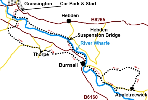
Introduction:
This walk from Grassington to
Appletreewick goes via the hamlet of Thorpe and village of Burnsall and
provides as much interest from the places it visits as well as the lovely
views en route.
It is a versatile walk in that if you do not
want to picnic, there are good pubs where food and excellent real ale can be
purchased at all places (except Thorpe).There are also permutations of
distance, in that sections can be treated as separate walks. The most
obvious options are:
1)
Full walk as described – 11 miles;
2)
Walk from Grassington to Burnsall and return to start direct
from Burnsall along the river Wharfe – 6.6 miles;
3)
Walk from Burnsall to Appletreewick (circular) – 4.4 miles.
The walk starts from the main car park in
Grassington. To get there, follow the B6265 north from Skipton and turn
north east at Thresfield. The road turns sharp right at the entrance to the
village and the car park is after 100 yards or so on the right. It is hardly
worth trying to park in the village itself as it gets quite busy especially
in peak season and parking is limited. The village is very picturesque, with
its quaint cobbled market square and is worth a visit.
En route, notable sights are Linton Falls,
the hamlet of Thorpe, which seems untouched by time, Burnsall with its
impressive bridge over the river Wharfe and Mock Beggar Hall at
Appletreewick, a house dating from the 15th century (with later
additions) and originally a monastic grange belonging to Bolton Priory. You
also cross the narrow Hebden suspension bridge, a somewhat interesting
experience!
%20Grassington%20centre.jpg)
Start:
With your back to the Yorkshire Dales National Park centre in the car park
(SE 003638), walk across the car park,
bearing left, until you come to the footpath going right, down to Linton
Falls. Cross the falls by the bridge and turn right then left at the old
packhorse bridge (do not cross it). On reaching the road turn left.
%20Linton%20Falls.jpg)
If you want to visit Linton Church, this can
be visited by following this road for a few hundred yards to its end.
Otherwise, after
passing the car park and public toilets,watch out for a footpath on the right (SE
003632) indicated by a sign on the side of a house stating "B6161 via
Stickhaw ½ mile" and "Linton Camp ¼ mile". After 50 yards,
turn right by the sign “Linton via B6160”. On reaching the road, turn
right and at the fork, go left.
About 300 yards from the junction, take the
footpath on the left indicated by a fingerpost for “Thorpe Lane ½
mile”, “Threapland 2¾ miles” and “B6160”
(SD 999629).
The path goes straight through the farmyard
and enters a large field. Head for a spot about half way along the opposite
wall and join a broad track through a walkers’ gate. Turn left. You pass a
fingerpost for Threapland but do not go in that direction. You soon pass
another fingerpost pointing in your direction of travel to Thorpe.
Pass and ignore a track on the left which
just goes into a field.
At the top of a slope, enter a large field
and follow the left hand boundary to a gate next to which is a gated stile.
Through this, head towards the left hand side of the trees straight ahead.
%20View%20over%20Grassington.jpg)
Pass the trees and follow the right hand
field boundary to the top right hand corner of the field, go over a gated
stile and turn left on Thorpe Lane (SE 005621).
You arrive at a ‘T’ junction (SE 013620).
Turn right into the hamlet of Thorpe. Turn left at the fork in the road (SE
013618) and climb the hill out of the hamlet. As it bends sharp left (SE
015619), take the track on the right signposted “Burnsall 1¼ miles”.
%20The%20manor%20house%20Thorpe.jpg)
It starts off as a stony track then turns
grassy. Follow the track to a walkers gate, go through it and follow the
well marked path downhill, a few yards right of the trees.
At the end of the trees, follow the wall and
fence round to the
left crossing a stream via a plank, after going through a gated slit stile.
The path, which is easy to follow, then
crosses a series of gated stiles and a couple of stone tracks before
arriving in Burnsall. Turn right and follow the road round to the bridge
over the river Wharfe.
%20Approaching%20Burnsall.jpg)
%20Burnsall.jpg)
%20Burnsall%20Bridge.jpg)
To return to Grassington (Route 2, the 6.6
mile option), do not cross the river bridge but turn left to follow the left
hand bank of the river back. You cross Hebden suspension bridge then follow
the right hand bank to Linton Falls, then turn right, back to the car park.
To continue the full walk (or if just doing
the Burnsall/Appletreewick option – park at Burnsall) cross the river
bridge and after about 100 yards, turn right to follow the Dalesway footpath
signposted for “Appletreewick 1 mile” and “Howgill 2 miles” (SE
034612).
Note that the wide curving track on the
right, to the river, should be ignored. You want the grassy path bearing
left. The path soon joins the river. Follow its bank until you reach a path
on the left indicated by a fingerpost for “Appletreewick” (SE 047600),
which runs alongside a campsite. Take this path and on reaching the road,
turn right into the village.
%20Appletreewick%20Main%20St.jpg)
%20Mock%20Beggar%20Hall.jpg)
Pass Mock Beggar Hall then, after passing the
church of St John the Baptist, turn left, following the fingerpost for
“New Road ½ mile” and “Dibbles Bridge 2 miles”
(SE 055601).
As the track bends left, keep straight ahead
in the direction of Dibbles Bridge. The walled track opens into a field and
goes through a gateway into a second field. Bear left here and as you draw
level with the rear of the barn, look over to the left where there is a
stone stile. Cross this and turn right.
Head for another stile in the top corner of
the field. Over this, follow the footpath signposted “Hartlington”.
There are three gates out of the next field. Between
the left two, is a stone stile with a yellow topped post (SE 058609). Cross
this and turn left, following the wall on the left. There are good views in
all directions along here.
When you reach a broad track, basically go
straight ahead to a metal gate, where there is a fingerpost indicating the
route as “bridleway”. Stay on the main track ignoring any turns off.
When the track forks, the left hand fork
going to a farm, keep right. Follow the track (Kail Lane on the OS map) to
the road (SE 041608). Take the track opposite. As you reach a farm, turn
right (there is a fingerpost indicating left to Appletreewick and right to
Burnsall. Cross a long narrow timber bridge. At the river turn right,
retracing your steps back to Burnsall.
%20River%20Wharfe%20at%20Loup%20Scar.jpg)
%20Hebden%20suspension%20bridge.jpg)
From Burnsall, follow the left hand bank back
for about a mile then after crossing over Hebden suspension bridge, follow
the right hand bank back to Linton Falls where you turn right back to
Grassington. En route note the fine Linton Church seen from across the river.
%20Linton%20Church.jpg)
If you need to buy any
hiking equipment/clothing before your trip see the Hiking
Store
All information on this
site is given in good faith and no liability is accepted in respect of any
damage, loss or injury which might result from acting on it.
|


.jpg)
.jpg)
.jpg)