|
Gordale
Scar and Malham Cove
Starting point and OS Grid reference:

Roadside
parking at Malham (SD 900625)
|
Ordnance Survey Map
OL2
Yorkshire Dales – Southern and Western.
Buy
this map from
List
of OS Maps
Note: If you use OS Maps on-line, you can download this route via this
link.
| |
Distance:
7 miles
|
Date of Walk:
14 June 2011
| |
Ascent:
Descent:
See Walking Time Calculator
|
285m (938ft)
286m (936ft)
| |
Traffic
light rating:
 
(For explanation see My
Walks page)
| |


For advice on .gpx files see
My Walks page
|

Click
the PDF logo above to give a printable version of this walk without the
photos.
|
To view route as a dynamic
Ordnance Survey map click here.
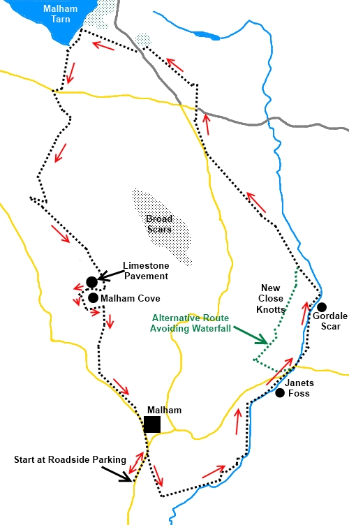
Introduction:
This
is the classic circular walk that many people do when visiting the Malham
area. It combines the attractive waterfall of Janet’s Foss, the dramatic
gorge of Gordale Scar and the truly magnificent Malham Cove. Above the cove
you walk (carefully to avoid breaking ankles!) across the famous limestone
pavement with its “clints” (the limestone blocks) and “grikes” (the
fissures between the blocks).
The
walk as described involves scrambling up the waterfall at Gordale
Scar. Whether you are up to this depends on you and the amount of water coming
over the fall. If in doubt, follow the alternative route described below.
The
walk starts from the village of Malham (SD 900625). To get there, turn off the A65
between Gargrave and Hellifield at Coniston Cold, signposted Bell Busk and
Malham. There is a pay and display car park at Malham but outside of peak
times, you can park for free on the road as you approach Malham. Public
toilets and refreshments are available in Malham.
%20Clapper%20Bridge.jpg)
Start:
Start
the walk by crossing the small stone clapper bridge behind the old smithy
building. Turn right and follow the stream until you reach a finger post
pointing left “Janet’s Foss 1 mile” (SD902624). Turn left here and
follow the obvious path which soon runs alongside the stream. The waterfall
Janet’s Foss is on the right in a shady dell which it is believed
originates from the last ice age. A notice at the site gives information.
%20Janets%20Foss.jpg)
Continue
to follow the path until it exits into a road (SD 912634). Turn right and
note the lay-by on the left as this is your reference point for the
alternative path should you need it.
Continue
along the road for about 150 yards and turn left at a gate signed to Gordale
Scar. Follow the track up the gorge to the see the waterfall.
%20Gordale%20Scar.jpg)
%20Climber.jpg)
%20Waterfall.jpg)
The
waterfall is best climbed up the left hand side. After heavy rain or if you
do not feel up to the climb, return to the lay-by mentioned above at the
back of which is a kissing gate. Go through this and as you walk along the
path for 300/400 yards look out for a path ascending the hillside on the
right hand side (New Close Knotts). There is no path shown on the OS map for
this but it is a fairly obvious path with access gate. This is a steep climb
and at the top, bear right to the edge of the gorge and follow it along to
connect with the path from the waterfall at SD 914643.
%20Gordale%20Scar%20fro%20New%20Close%20Knotts.jpg)
Assuming
you have climbed the waterfall, the path then climbs the left hand side of
the steep valley (SD 914643).
You
arrive at a stone stile and a finger post to Malham Tarn 2 miles.
Follow the obvious track until it exits into
a road (SD 906653). Turn right then immediately bear right again off the
road and on to a track. At the crossroads, keep straight ahead. After about
200 yards, start to bear left across the grass towards a clump of trees (SD
901662). Turn left at the trees and follow the wall round and head for a
second group of trees down by the water.
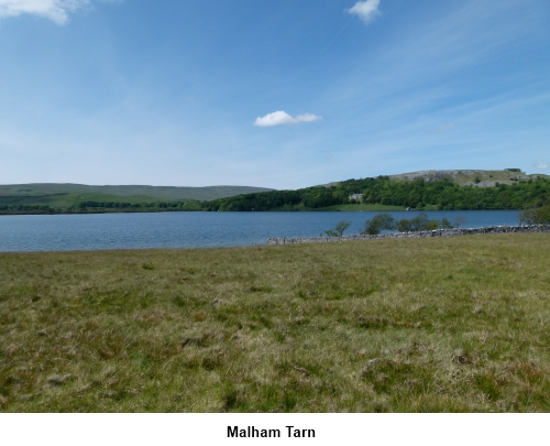
Enjoy the sight of Malham Tarn and any bird
life before turning left to follow the track which parallels the stream to
the road. Turn right to cross the stream via the road bridge then go left
where the finger post indicates Malham Cove 1½ miles (SD 893658).
Bear right and on reaching the wall, follow
it, ignoring a stile which crosses it.
After rounding a bluff, looking down over a
dry valley, you arrive at a double stile with a finger post indicating the
Pennine Way and Malham Cove ½ mile to the left (SD 891649). This is your
route, along the dry valley.
%20Dry%20Valley.jpg)
The extensive limestone pavement with its
“clints” and “grikes” indicates you have reached the top of Malham
Cove. The pavement was scraped bare by the glaciers during the ice age and
has been steadily eroded by rainwater ever since. It is worth cautiously
approaching the edge for the best of the view. Do not go too close however
as it is a long way down! Also be careful in wet weather as the limestone
gets slippery. You may see peregrine falcons which live on the rock face.
%20Edge%20of%20Malham%20Cove.jpg)
%20View%20from%20Malham%20Cove.jpg)
%20Limestone%20Pavement.jpg)
With the precipice in front of you, head
right across the limestone pavement, bearing left until you reach a wall at
the end of it. Turn left here and follow the stepped path down to the valley
floor. When you get to the bottom, there are often RSPB representatives who
will let you look through powerful binoculars at the peregrine falcons. Turn
left for a close up view of the cove but otherwise turn right and follow the
path back to Malham.
%20Malham%20Cove.jpg)
If
you need to buy any hiking equipment/clothing before your trip see the Hiking
Store
All information on this
site is given in good faith and no liability is accepted in respect of any
damage, loss or injury which might result from acting on it.
|


.jpg)
.jpg)
.jpg)