|
Crag
Hill and Great Coum
Starting point and OS Grid reference:

Dent
Village pay and display car park (SD 705871)
|
Ordnance Survey Map
OL2
Yorkshire Dales – Southern & Western areas.
Buy
this map from
List
of OS Maps
Note: If you use OS Maps on-line, you can download this route via this
link.
| |
Distance: 7.5
miles
|
Date of Walk: 1
May 2015
| |
Ascent:
Descent:
See Walking Time Calculator
|
1883ft (574m)
1883ft (574m)
| |
Traffic
light rating:  
(For explanation see My
Walks page)
| |


For advice on .gpx files see
My Walks page
|

Click
the PDF logo above to give a printable version of this walk without the
photos.
|
To
view route as a dynamic Ordnance Survey map click here.
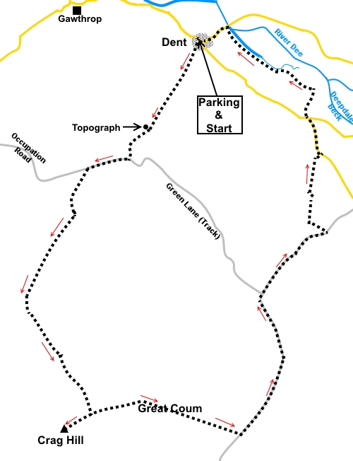
Introduction: This walk from Dent
should not be taken lightly because there is an extremely steep quarter mile
section to Crag Hill. No scrambling is involved and the terrain is merely
grassy but the incline will make you puff! The descent is also somewhat
knee-grinding! However, the views from Crag Hill at 2238ft (682 metres) make
the effort worthwhile. You get the panorama of Morecambe Bay round to the
Lake District plus a great view to Ingleborough. The route then passes over
Great Coum, slightly higher at 2254 ft (687 metres), before dropping down to
a bridleway in Deepdale.
The route takes you initially along the
course of Flinter Gill, to an old green lane known as The Occupation Road,
before turning off Ordnance Survey marked Rights of Way to make its way
across Access Land and up the fells to Crag Hill. Although clearly visible,
trodden turf eventually peters out, the route follows walls which the
directions refer to, so navigation should not be a problem
The final part of the return journey takes
you through the cobbled streets of the very picturesque village of Dent with
an opportunity for refreshment at a couple of pubs/cafes. There are no
refreshment stops en route other than what you bring with you.
The walk starts from the pay and display car
park in Dent where there are public toilets.
There are several ways to get to Dent,
depending on from which direction you approach so consult an atlas/sat. nav
or check the icon at the top of the page.
Start: From the car park entrance,
cross Main Street and continue up the road directly opposite, to the left of
the Memorial Hall. When the road bends left at the little green, keep
straight ahead, following the fingerpost for Flinter Gill.
%20Looking%20back%20to%20Dent%20Village%20Green.jpg)
Follow the tarmac to its end when it becomes
a steeply climbing stony track (bridleway).
%20Track%20out%20of%20Dent.jpg)
Pass a restored limekiln.
Go through a farm gate and to the right on
the grass banking is a topograph (or orientation table, SD 699862) which, on
its metal plaque, shows you which hills are in which direction. It is worth
the few yards climb to this point, as the views across to the Howgill Fells
and up Dentdale are superb.
%20Topograph.jpg)
%20View%20To%20Howgill%20Fells.jpg)
After going through another gate where there
is a bench, at a ‘T’ junction of tracks (SD 698859) turn right following
the public bridleway fingerpost for “Keldishaw 1½ miles”. This track is
The Occupation Road, an old “green road” dating back to the Enclosure
Acts of the 1850s , which connected Barbondale and Kingsdale, so that
landowners could access their newly enclosed lands.
Follow the track for a quarter of a mile and
through one more gate, then turn left on to another lesser status walled
track.
%20Great%20Coum.jpg)
This track leads to more open pasture. Keep
following the wall on the right. This wall gradually curves left and as you
get to the steeper section, the track itself becomes more and more faint.
Continue to follow the wall up the hill to the ridge. This is the very steep
section which earns the walk its “red traffic light”!
%20View%20to%20Ingleborough.jpg)
At the corner of the wall you have followed
and the wall along the ridge is a stone stile (SD 694835). Cross this then
immediately cross a wooden stile and turn left to the trig. point on Crag
Hill (SD 692833). There are excellent views over Morecambe Bay, to the Lake
District and to Ingleborough.
%20Crag%20Hil%20Summit%20and%20view%20to%20Morecambe%20bay.jpg)
%20Crag%20Hil%20Summit%20and%20view%20to%20Lake%20District.jpg)
%20Telephoto%20shot%20of%20the%20lake%20District.jpg)
From the trig. point (SD 692833), retrace
your steps to the wooden stile, cross it and turn left along the ridge.
There are one or two projecting “through” stones in the wall here where
you can perch for a picnic out of the prevailing wind.
Follow the wall on your left along the ridge
until it meets another. Cross the stone step stile on the left then turn
right (ignoring the second, gated stile), to follow the other side of the
ridge wall.
%20Crag%20Hill%20From%20Great%20Coum.jpg)
You might have to weave around a little for
the best route but basically follow the wall down the hill into Deepdale,
until you meet another wall, topped with barbed wire (SD 709833)! Over the
wall you will see a walled track which you need to join. Turn left to follow
the wall along until you reach a gate enabling you to join the track.
%20Descent%20of%20Great%20Coum%20towards%20deepdale.jpg)
%20View%20NE%20Along%20Dentdale.jpg)
At a four way fingerpost, the main track
turns left but you continue straight on, over a wooden stile, down
another track, following the fingerpost for “Nun House” and “Outrake 1
Mile” (SD 711846).
%20Track%20to%20Outrake.jpg)
%20Dentdale.jpg)
Look out for a barn in the field to the left
and yards after passing it, look out for ladder stile on the left with a
yellow public footpath arrow (SD 717852). Cross the stile and pass the barn
to another gate with a white direction arrow.
Bear right to drop down in front of the
ruined farmhouse and to the right hand side of another barn. Cross the field
and over a small stream (which may be dry) then pass to the left of a small
copse of trees, through which the stream flows. The continuation of the
route is then clear below.
Cross the stream and the path then curves
left to a ladder stile. Cross this then go over the gated stile ahead.
Go through a gate to the left of the barn and
head to the bottom left hand corner of the field where the yellow footpath
arrow indicates your route to the right. Follow the footpath round the back
of the houses to the road than turn left.
Follow the road to a junction (SD 716863).
Take the track straight ahead down towards the river just along the track a
few yards is a fingerpost indicating “Bridleway Double Croft Lane”.
The track turns left to some house by a barn.
My original intention was to continue to the river then turn left and follow
the river back to Dent. However, there is a sign here which warns that the
bridleway is prone to flooding and indeed it proved to be flooded to an
above boot depth on my visit. I therefore turned left, through a walkers'
gate, along the footpath just before the houses (SD 716865).
Through a second walkers’ gate, turn left.
A combination of worn turf, arrows, gates and
stiles now make the rest of the route to Dent obvious. On reaching the road
by the bridge, turn left and walk through the pretty village of Dent back to
the car park.
%20Views%20of%20Dent%20Village.jpg)
If you need to buy any
hiking equipment/clothing before your trip see the Hiking
Store
All information on this
site is given in good faith and no liability is accepted in respect of any
damage, loss or injury which might result from acting on it.
|


.jpg)
.jpg)
.jpg)