|
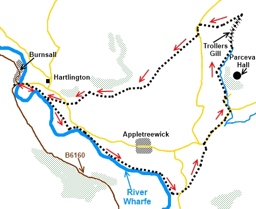
Burnsall
to Troller's
Gill
Starting point and OS Grid reference:

Burnsall
(SE 032611) – Limited road parking plus pay and display cp.
|
Ordnance Survey Map
OL2
Yorkshire Dales - Southern and Western Areas.
Buy
this map from
List
of OS Maps
Note: If you use OS Maps on-line, you can download this route via this
link.
| |
Distance: 7.3 miles
|
Date of Walk: 13 September 2023
| |
Ascent:
Descent:
See Walking Time Calculator
|
908ft (277m)
906ft (276m)
| |
Traffic
light rating: 
(For explanation see My
Walks page)
| |


For advice on .gpx files see
My Walks page
|

Click
the PDF logo above to give a printable version of this walk without the
photos.
|
To
view route as a dynamic Ordnance Survey map click
here.
This walk is now available
as a Kindle book. Click the symbol for further details

Introduction:
This is a
short walk but through interesting scenery in the shape of the limestone
gorge of Troller’s Gill. According to legend, all sorts of evil creatures
including a monstrous black dog called Barghest live in this gorge but I was
unmolested when I walked through it! The gorge is not on an official
footpath route according to the OS map so it is often an eerily silent place
but walkers are catered for by stiles at the top. The going is rocky but not
difficult. It just takes a little care to avoid turning an ankle. This route
also provides for a very pretty walk alongside the River Wharfe.
Start the
walk in the Dales village of Burnsall. There is a car park although on quiet
days, it is possible to park on the main street by the river where there are
benches to sit and feed the ducks or put on boots.
Start: Turn
right over the road bridge and immediately over the bridge, turn right at a
fingerpost signposted Dalesway and Appletreewick. Walk across the pleasant
river meadow ignoring the request for pedestrians to pay £2.00 (2023 price.
Note the route is a public footpath for which there should be no charge) and
follow the Dalesway along the very pretty riverside path. The footpath runs
on the top side of the banking by a bench. Continue for about two miles,
passing straight through a farmyard, until you reach a road near Howgill (SE
060593).
%20View%20from%20Burnsall%20Bridge.jpg)
%20Along%20the%20riverside%20path.jpg)
%20View%20to%20Simon's%20Seat.jpg)
As you
get to the road, keep straight ahead for a few yards before turning left
along it, otherwise you will end up in someone’s drive! Just past the old
Weslyan Chapel (Chapel House), turn right through gated stile on to footpath
signposted Skyreholme (SE 061594). Keep to the higher ground climbing
gradually (do not go down to the stream).
Cross
a gated stile above a caravan park and bear left along the farm drive to
exit into road at Howarth Farm (SE 064602). Turn right.
At the next road junction
(where there is a bench for lunch!) turn left, following the fingerpost for
“New Road 1 Mile” (SE 069607). Follow the road around a right hand bend
and just before the entrance to Parceval Hall, turn left to follow the south
west bank of Skyreholme Beck (SE 068610).
Ignore the first path off
to the left after 100 yards or so and at the next junction, fork right, just
after going through a walkers’ gate (SE 068617). This is where you leave
the official footpath route which is shown on the OS map, to take advantage
of Access Land (SE 086616)
%20Approach%20to%20Trollers%20Gill.jpg)
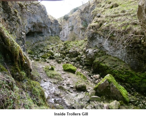
You approach and enter Troller’s Gill after
crossing a stile. Skyreholme Beck obviously once used to flow through this
gorge and was no doubt responsible for creating it but the beck now emerges
at the foot and the gorge itself is dry. Please note that I have walked this
gorge several times over the years and never seen any water flowing through
it. However, it can flow through after exceptionally heavy rain and if this
happens, do not try to pass through but return to the official footpath
referred to in the last paragraph.
%20Entrance%20to%20Trollers%20Gill.jpg)
At the top of the gorge is a ladder stile.
Once over this, follow the valley. The beck re-appears and you eventually
come to a precarious looking plank bridge across it. Cross the bridge (SE
071623) and go through the walkers’ gate.
A short steady climb now
until the track splits. Follow the gravel track until just before it bends
sharp right, turn left to follow the well trodden grassy route to the road.
%20Looking%20North%20from%20Gill%20Heads.jpg)
%20View%20towards%20Grassington%20Moor.jpg)
%20Just%20a%20view.jpg)
Turn left on road. Ignore
the first footpath on right. Take second where finger post points to
Hartlington one and three-quarter miles along a broad track (SE 623620). It
forks at a farm – take right fork.
At the next group of farm buildings, fork
right down the walled track (Kail Lane on OS map) (SE 049610). Cross over
the road you come to and after about 150 yards, turn right following the
Burnsall sign crossing a narrow single plank bridge.
If you need to buy any hiking
equipment/clothing before your trip see the Hiking
Store
All information on this
site is given in good faith and no liability is accepted in respect of any
damage, loss or injury which might result from acting on it.
|


.jpg)
.jpg)
.jpg)