|
Buckden
to Yockenthwaite
Starting point and OS Grid reference: 
Pay and display car park at Buckden (SD 942773)
|
Ordnance Survey Map
OL30 - Yorkshire Dales Northern and Central Areas.
Buy
this map from
List
of OS Maps
Note: If you use OS Maps on-line, you can download this route via this
link.
| |
Distance: 6.9
miles
|
Date of Walk: 6 March 2012
| |
Ascent:
Descent:
See Walking Time Calculator
|
891ft (272m)
893ft (272m)
| |
Traffic
light rating: 

(For explanation see My
Walks page)
| |


For advice on .gpx files see
My Walks page
|

Click
the PDF logo above to give a printable version of this walk without the
photos.
|
To
view route as a dynamic Ordnance Survey map click here.
This walk
is now available as a Kindle book. Click the symbol for further details

Introduction:
Walks from Buckden do not come much nicer than this. Virtually everyone
who walks from here covers this popular route sooner or later. A consequence
is that it is easy to follow but even on a quiet day you are unlikely to
have it to yourself. However, it is still worth walking as, for relatively
little effort, the views are superb, extending along Wharfedale,
Langstrothdale and across to Buckden
Pike.
After an initial moderate climb along a former Roman road (Buckden
Rake) and then descent to the picturesque hamlet of Cray, it follows a level
terrace around the valleys before descending to Yockenthwaite (basically a
large farm) then following the course of the river Wharfe via the Dalesway
to Hubberholme and Buckden.
Refreshments are available at the White Lion
at Cray, The George at Hubberholme and the Buck Inn plus cafes at Buckden.
The George has variable opening hours so check if relying on this.
Hubberholme has an ancient church which began
life in the 12th century and is famous for its rood screen, the
pews made by the “Mouseman” of Kilburn (with the mouse carvings) and as
the resting place for the scattered ashes of the author J.B. Priestley (1894
–1984) – there is a plaque inside the church.
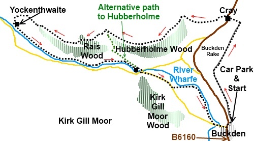
To get to Buckden, head north out of Skipton
on the Grassington road (B6265). At Threshfield, ignore the right turn to
Grassington and continue ahead, now on the B6160 to Buckden. The car park is
through the village on the right
(SD 942773).
%20Route%20from%20Buckden%20car%20park.jpg)
Start:
Leave the car park (SD 942773) at the opposite end to the toilets, via a
gate signposted Buckden Pike and Cray High Bridge. The stony track climbs
steeply until it meets a stone wall (SD 940783). Continue with the stone
wall on your left until your path is crossed by a gate and a finger post (SD
941785) signposted Buckden Pike to the right. Carry straight on signed for
Cray High Bridge.
%20Looking%20back%20towards%20Buckden.jpg)
%20View%20Across%20Wharfedale.jpg)
%20Looking%20up%20Wharfedale%20from%20Buckden%20Rake.jpg)
Ignore an opening in the wall on the left and
keep straight ahead through a gateway next to a very large rock. Immediately
after this is a sheepfold on the left.
Pass a faint track on the left going off at
about 45° and go through two gateways (no gates) ahead. At the next wall
(SD 944741), go round the left hand corner from where the path descends,
alongside a wall, to the hamlet of Cray. Turn right at the wall corner where
there is a finger post confirming the footpath.
%20Cray.jpg)
Cross the stream via the stepping stones
(these are limestone so be careful if they are wet) and take the broad track
stony directly opposite and follow the fingerpost. The track bears left
behind the pub and farm buildings.
%20Stepping%20Stones%20at%20Cray.jpg)
When the path divides (SD940791), take the
right fork at a three way fingerpost then follow another fingerpost for
Yockenthwaite and Scar House.
From here simply follow the almost level
terrace around the valleys.
After passing a stone barn with an arched
door, join a track coming from the left and go right (left is private). Just
beyond here are some suitable rocks for a lunch stop with good views. Just
beyond them, cross a little footbridge and turn left.
Continue following the terrace and ignore a
path on the left at SD 922789, behind Scar House farm, unless you want to
shorten the walk and go directly to Hubberholme – it rejoins my walk at
the church.
%20Buckden%20Pike.jpg)
As you pass the farm, the path descends
slightly to a three way fingerpost. Follow the direction of Yockenthwaite,
through a gated stile.
Stay on the terrace and go through a wood,
exiting via a footbridge. Bear left at about 45° immediately after the
bridge to a gated stile in the next wall. Follow the track along.
%20Looking%20up%20Langstrothdale.jpg)
The bridge over the river Wharfe and farm at
Yockenthwaite become visible below. Look out for a fingerpost on the left,
at which point the path descends to Yockenthwaite via a series of gates and
stiles. At a broad stony track, go left down to the farm (SD 906790) where
there is a fingerpost indicating your route - Hubberhome 1½ miles.
%20Yockenthwaite.jpg)
%20Hubberholme%20Church.jpg)
%20Mouse%20Carving%20on%20Pew%20at%20Hubberholme%20Church.jpg)
Follow the river to Hubberholme. The square
bell tower of the church comes into view. Pass in front of the church – it
is worth a look – over the river bridge and turn left along the road. Pass
Kirk Gill Manor on the left, Grange Farm on the right and then just past a
stone barn on the left, as the road bends to the right, take the footpath on
the left signposted Dalesway Footpath Buckden Bridge ¾ mile. The path to
Buckden is clear.
If you need to buy any
hiking equipment/clothing before your trip see the Hiking
Store
All information on this
site is given in good faith and no liability is accepted in respect of any
damage, loss or injury which might result from acting on it.
|


.jpg)
.jpg)
.jpg)