|
Buckden
to Kettlewell
Starting point and OS Grid reference:

Buckden
- pay and display car park (SD 943774)
|
Ordnance Survey Map
OL
30 Yorkshire Dales – Northern and Central Areas.
Buy
this map from
List
of OS Maps
Note: If you use OS Maps on-line, you can download this route via this
link.
| |
Distance: 8.9
miles
|
Date of Walk: 28
November 2014
| |
Ascent:
Descent:
See Walking Time Calculator
|
679ft (207m)
674ft (205m)
| |
Traffic
light rating: 

(For explanation see My
Walks page)
| |


For advice on .gpx files see
My Walks page
|

Click
the PDF logo above to give a printable version of this walk without the
photos.
|
To
view route as a dynamic Ordnance Survey map click here.
Introduction: This
easy to navigate walk from Buckden to Kettlewell follows the fell side to
Kettlewell, l then returns via the valley bottom riverside footpath which is
part of the Dalesway. The first mile involves some work uphill but is then a
very gentle downhill stroll to Kettlewell and a level walk back. There are a
lot of stiles on the route to Kettlewell.
There are
refreshment opportunities at pubs/cafes in Kettlewell and also theoretically
at the Fox and Hounds pub in Starbotton but it has never been open when I
have passed, so I would phone to check before you rely on it. There are
public toilets in Buckden and Kettlewell.
The walk starts at
a pay and display car park in the pretty village of Buckden. To get to
Buckden, head north out of Skipton on the Grassington road (B6265). At
Threshfield, ignore the right turn to Grassington and continue ahead, now on
the B6160 to Buckden. The car park is through the village on the right (SD
942773).
Unfortunately, it
was a grey misty day when I did this walk so photos are limited.
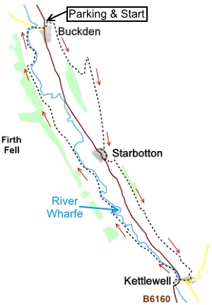
Start: Leave the car park (SD 942773) at the opposite end to the
toilets, via a gate signposted Buckden Pike and Cray High Bridge but
immediately through the gate, turn right to follow the fingerpost for
“Path leading to Buckden Lead Mine and Starbotton” (SD 942772).
When you get to the
stream, although it seems counterintuitive, turn right to access stepping
stones. Cross these, then follow the obvious path as it zig-zags up the
hill.
%20Looking%20Down%20on%20Buckden.jpg)
%20Looking%20up%20Wharfedale.jpg)
After crossing a
small stream (which might be dry in summer), go up the right hand side of a
dilapidated wall and come to a three way fingerpost (SD 950767). Turn right
for Starbotton.
The hard work is
now done and the path is now much more level (you may be pleased to know!)
and more or less follows the contours of the hill whilst descending very
gradually to Starbotton. There are a number of posts with yellow tops along
the way to guide you.
You arrive at
another three way fingerpost. Turn right for “Starbotton 1/3
mile”.
At the junction of
the footpath and the road in Starbotton, turn left along the road through
the village, only for 200 yards or so. Just past a bench, turn left to
follow the fingerpost for “Kettlewell 2 miles”.
You soon go through
a gateway with another fingerpost, turn left to go slightly uphill along the
field to a rather unusual stone step stile in that it has a handrail (SD
956747). Over the stile, turn right.
When the path
arrives in Kettlewell, follow the road straight ahead to the village centre,
passing the village hall and coming to the Racehorses pub. If required, you
now have a choice of pubs for refreshment. If you want somewhere in the
village to sit for a picnic, there are some benches opposite the Blue Bell
Inn or on The Green (cross the bridge over Kettlewell Beck and turn left.
The benches are in an “island”). There is another pub, The King’s Head
on The Green.
To continue the
walk, follow the main road (B6160) south out of the village, passing the
main car park and toilets.
Cross the bridge
over the River Wharfe and immediately, turn right, to follow the fingerpost
for the “Dalesway” and “Starbotton 2 miles Buckden 2 miles” (SD
967722).
%20Returning%20Along%20the%20Valley.jpg)
%20Looking%20Towards%20Middlesmoor%20Pasture.jpg)
It
is now a case of simply following the Dalesway to Buckden. In any cases of
doubt, keep to the path closest to the river. The path runs along the valley
bottom, more or less parallel with the river although the river meanders and
is not always next to the path. Pass but do not cross a footbridge to
Starbotton.
%20Footpath%20near%20Starbotton.jpg)
At SD 939765 turn right at a two way fingerpost showing the Dales Way in
each direction. In effect, it is the first right turn you come to.
%20Approaching%20Buckden.jpg)
At
the road, turn right to retrace your steps to Buckden.
If you need to buy any
hiking equipment/clothing before your trip see the Hiking
Store
All information on this
site is given in good faith and no liability is accepted in respect of any
damage, loss or injury which might result from acting on it.
|


.jpg)
.jpg)
.jpg)