|
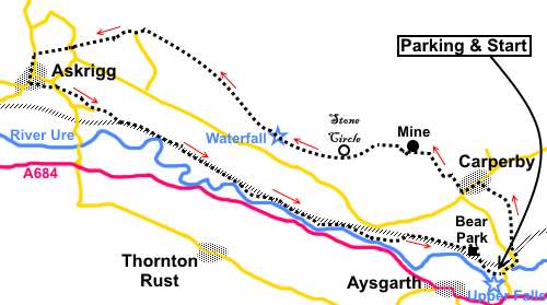
Aysgarth
Falls to Askrigg
|
Starting point and OS Grid reference:
Aysgarth
Falls – YDNP pay and display car park (SE 010886)
|
Ordnance Survey Map
OL30
– Yorkshire Dales Northern and Central.
Buy
this map from
List
of OS Maps
Note: If you use OS Maps on-line, you can download this route via this
link.
| |
Distance: 9.8
miles
|
Date of Walk: 8 April 2015
| |
Ascent:
Descent:
See Walking Time Calculator
|
1010ft (308m)
1004ft (306m)
| |
Traffic
light rating: 
(For explanation see My
Walks page)
| |


For advice on .gpx files see
My Walks page
|

Click
the PDF logo above to give a printable version of this walk without the
photos.
|
To
view route as a dynamic Ordnance Survey map click here.
Introduction: This Wensleydale walk from Aysgarth Falls takes you to
the attractive villages of Carperby and Askrigg. In the process you get some
tremendous views of Wensleydale without having to do a great deal of
climbing. The route passes evidence of mining indicating the valley was not
always just a rural idyll!
Aysgarth
Falls is a well known beauty spot. The falls tumble over a series of
limestone steps and featured in Kevin Costner’s film “Robin Hood Prince
of Thieves”. The walk starts at the Yorkshire Dales National Park car park
but saves the Upper Falls until the end. The route does not include the
Middle and Lower Falls but these could be visited afterwards by walking a
further half mile along the river.
At
the river bridge, note the massive four storey mill building, Yore Mill,
originally built as a cotton mill in 1784 then rebuilt in 1852 after a fire.
It “multi-tasked”, carding and spinning knitting yarn and grinding corn.
Needless to say, the river Ure provided the power.
Carperby
was at one time a major centre in the valley and was granted a Market
Charter in 1305. It is a Conservation area and is unusual in that it has two
distinct centres. Its prosperity declined in the 16th Century as
Askrigg began to take over as the major commercial centre although there was
a revival in the 17th Century. The market cross which my route
passes bears the date 1674.
Askrigg
is a charming village with cobbled streets and was the setting for “All
Creatures Great and Small”. Skeldale House on Main Street was the vet’s
surgery. The name Askrigg stems
from old Norse words “askr”
(ash tree) and “hryggr”
(ridge). The town was at its most prosperous in the 18th Century,
deriving income from textiles, knitting and clockmaking.
There
are plenty of picnic spots en route and several refreshment opportunities in
Askrigg.
The
walk starts from the pay and display Yorkshire Dales National Park car park
at Aysgarth Falls where there is an information centre and toilets.
To
get there, turn north off the A684 for Aysgarth Falls (signposted), about
half a mile to the east of Aysgarth itself.
Start: Leave
the car park by the main car entrance and turn left along the road
(SE 010886). Follow it round the bend and
past the entrance to Aysgarth Falls station. Around 50 yards after the
entrance, turn right on to a footpath through the woods indicated by a
public footpath fingerpost (SE 012889).
Cross
another footpath and continue through a walkers gate, which takes you out of
the woods into a field. Cross a stile to the right of the grassy mound and
follow the obvious footpath across the fields, passing to the right of two
small barns. Through the next stile after the barns, turn sharp left (the
fingerpost was a little misleading when I did the walk).
Go
through a gated stile on to the tarmac lane SE 011896). Turn right then
immediately left to follow the fingerpost for “Carperby”.
In
the second field after the lane, head for the far left hand corner of the
field, through a gated stile then turn right to follow another fingerpost
for “Carperby”. The path exits into the main street through Carperby,
almost opposite the Wheatsheaf Inn (SE 008898). Turn left.
Walk
along the street and when you get to the market cross (a Scheduled Ancient
Monument), follow the road to its right. When the tarmac ceases, turn right
along the left hand side of the bungalow and through a walkers’ gate (SE
005897).
%20Market%20Cross%20Carperby.jpg)
At
the farm, go straight on between the barns and into a long narrow field,
exiting in the top left hand corner, through a squeeze stile. Then, bear
left at about 45° to the next (gated) stile. Through this, turn right on a
broad track. This goes through one field and in the next, turns left but
here you leave it go straight on climbing slightly.
%20View%20on%20route%20from%20Carperby.jpg)
%20Another%20view%20on%20route%20from%20Carperby.jpg)
%20Addleborough.jpg)
Go
through a gate and turn left, where the wide path levels off. At SD 999902
is the entrance to Carperby stone mine, where sandstone was mined from a
narrow band and used for roofing local buildings until 1914.
Continue
past the mine. The path meets a wall and curves right to follow it, before
turning left through a gateway, at the foot of a steep banking.
Not
far past the gate, the path forks. Take the left fork and go through another
gate.
At
SD 990901you pass to the left of Ox Close stone circle, an Iron Age,
Scheduled Ancient Monument. This section of path is named as Ox Close Road
on the OS map.
%20Looking%20West%20along%20Wensleydaye.jpg)
You
start to cross a broad plain with old spoil heaps, a legacy from extensive
lead mining at Ivy Scar. When the path divides, take the left fork to follow
the bridleway fingerpost.
%20Ivy%20Scar%20&%20spoil%20heaps.jpg)
At
SD 981904 you come to a gate with a sign “Boundary gate Please keep closed
at all times”, followed by a footbridge. Before through the gate, it is
worth taking the little path on the left and scrambling down for a good view
of Disher Force waterfall and remains of an old 1902 model Gilkes Vortex
Turbine. I am informed this was installed by the owner of Woodhall Garage,
in the village below, to supply electrical power to the garage. It
worked so well that it was able to supply electricity to his house and some
of the other houses in the village. Take care however because the path is
steep and limestone which can be slippery when wet.
%20Waterfall%20and%20pelton%20wheel.jpg)
%20Below%20the%20waterfall.jpg)
Return
to and cross the bridge above.
Pass
along a section where the path is walled and come to a three way fingerpost.
Keep straight ahead for “Askrigg Moor Road 2¾ miles”. Beyond the
fingerpost, follow the left hand boundary.
Go
through a gate in the far left hand corner and immediatelt through another
gate on the left to join a broad track. Turn right here.
Follow
the track until just past some more old mine workings, go through a gate by
a copse of trees (SD 978906).
%20Mining%20remains.jpg)
After
about a mile and going through a gate, the track becomes walled. On meeting
another broad track, turn right for about 75 yards then turn left over a
step stile folllowing the fingerpost for “Newbiggin” (SD 962918).
%20The%20Combs%20and%20Ellerkin%20Scar.jpg)
After
going through an open gateway, turn left and take the path through the
trees. At a wall, turn right and follow the wall along (do not be tempted by
the gate straight ahead). You should be going anti-clockwise round the
barns, which seems to be the opposite of the indication on the OS map.
As
you come round the corner of the barn, aim for and cross the step stile
ahead.
The
route is obvious over the next two stiles but then turn right to follow the
footpath to the hamlet of Newbiggin, which is visible.
Walk
through Newbiggin past its little green then take the track following the
fingerpost for “Moor Road ½ mile”. When the track turns into a field,
take the walled path off to the left, then follow the right hand boundary in
the next field.
At
Moor Road, turn left for Askrigg (SD 950915). As you come to the outskirts,
there is a handy bench for a picnic stop, on the left, with a good view over
the village to the distinctive hill Addleborough
(SD 950913).
%20Askrigg.jpg)
Moor
Road becomes Main Street in Askrigg and there are several places where
refreshments can be obtained.
The
onward route from Askrigg begins along a footpath off to the left as you
walk down Main Street. It is to the left of a house called Hillgarth and
there is a fingerpost attached to the wall of the adjacent house “Low Gate
(Worton Road) ¼ Mile” (SD 949911). Follow the track to a barn and go to
its left. Go through a walkers’ gate and follow the left hand boundary.
Look
out for a small gate by a barn and go through this to the road and turn left
and in a few yards, turn right indicated by a fingerpost for “Aysgarth”.
At
a barn, keep to its right, then over a stile next to a gate at the end of
the field. The next stile is straight ahead. Keep to the left of the next
barn then to a gate to the right of the power poles. There are two more
obvious stiles before arriving at the road (SD 958908). Turn left.
Walk
along the road for a quarter of a mile and after crossing a “Weak
Bridge”, turn left over a gated stile then right to follow the fingerpost
for Woodhall and Aysgarth. In the right hand corner of the field go over
another stile.
The
footpath now initially follows the course of the old railway line, sometimes
on it, sometimes to the north and sometimes to the south but the route is
well marked with yellow arrows and fingerposts. To the left is the Grade I
listed Nappa Hall, a former fortified manor house, built in the 1450s. At
SD 876898, the river Ure joins the party!
%20River%20Ure.jpg)
Follow
the footpath, now between the river and the old railway track. Keep a look
out for a bridge across the river. This might be difficult to spot when the
trees are in leaf but when you join a broad track which comes from the
bridge, go straight across following the fingerpost for “Aysgarth
Falls”.
The
path crosses the field at, theoretically, about 45 degrees heading to the
railway track once more but there was a large boggy area to negotiate when I
did the walk so I went round the right hand side of a prominent rock in the
middle of the field (SD 997890) and joined the railway line beyond that,
turning right. Follow the line briefly before branching off left via a
walker’s gate.
There
are now a series of stiles and fingerposts which make this well walked
section clear. You cross a lane leading to Bear Park, a 17th
Century Grade II listed building, with gardens (not open to the public). The
footpath route circumnavigates it in a clockwise direction, before cutting
through the railway embankment, then turning left to follow the river below.
It then drops down to Aysgarth Falls (Upper Falls).
%20Aysgarth%20Falls.jpg)
After
viewing the falls, follow the footpath to the road then take the elevated
path on the left back to the car park.
%20Yore%20Mill.jpg)
If you need to buy any
hiking equipment/clothing before your trip see the Hiking
Store
All information on this
site is given in good faith and no liability is accepted in respect of any
damage, loss or injury which might result from acting on it.
|


.jpg)
.jpg)
.jpg)