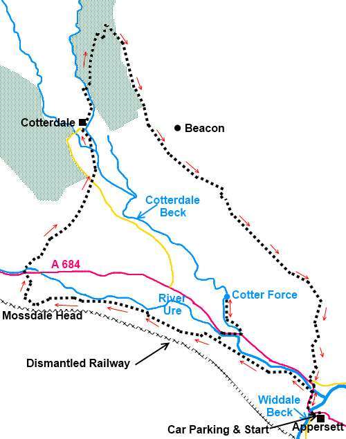
|
Appersett
to Mossdale and Cotterdale
|
Starting point and OS Grid reference:
Appersett
– large roadside rough lay-by (SD 858907)
|
Ordnance Survey Map
OL
19 – Howgill Fells and Upper Eden Valley.
Buy this map from
List
of OS Maps
Note: If you use OS Maps on-line, you can download this route via this
link.
| |
Distance: 9.1 miles
|
Date of Walk: 11 April 2012
| |
Ascent:
Descent:
See Walking Time Calculator
|
1458ft (444m)
1458ft (444m)
| |
Traffic
light rating: 

(For explanation see My
Walks page)
| |


For advice on .gpx files see
My Walks page
|

Click
the PDF logo above to give a printable version of this walk without the
photos.
|
To
view route as a dynamic Ordnance Survey map click here.
Introduction:
I imagine at least 90% of visitors to
the Yorkshire Dales know of Airedale, Wharfedale, Wensleydale and Swaledale.
However mention Mossdale and Cotterdale and I guess many brows would furrow.
Each form an arm at the north-west end of Wensleydale.
This extremely attractive walk explores both.
It takes you past the impressive waterfalls of Cotter Force and Mossdale
Beck before arriving at the unbelievably pretty and tranquil hamlet of
Cotterdale, in a dead end (by road) valley, which time looks to have
forgotten . It then climbs the lower slopes of Great Shunner Fell to reveal
stunning views of Cotterdale and Wensleydale and long distance glimpses of Ingleborough.
The walk starts from the small, rather plain
hamlet of Appersett, which lies a mile west of Hawes on the A684. There is a
large rough lay-by on the north side of the road in the hamlet, next to the
village green, where the locals often hang washing.
There are no refreshment opportunities en
route other than your own sustenance. Afterwards, there are plenty of
cafes/pubs in Hawes.
[Note:
Since I did this walk there have been a number of changes reported to me on
18 October 2024. Clearly identified changes have been incorporated into the
directions but some stiles have
been replaced by gates. The specifics are not known so you need to allow for
this].
Start:
From the lay-by (SD 858907) turn right (west). Cross the first river bridge over
Widdale Beck and walk along the A684 for about 200 yards. Immediately
before the next road bridge, on the left, go through a field gate. (SD
858909).
Follow the path along by the River Ure until
after crossing a ladder stile, it bears off slightly left and runs along the
top of a small wood. Continue to follow the path until you reach a ladder
stile on the right (SD 850913). This is the route to Cotter Force. Cross
this and descend through the woods.
At the bottom of the woods, cross a
footbridge and then turn left. Go to the right of a
barn where there is a fingerpost indicating the route. Follow the field wall
on the right until you get to its end at a fingerpost indicating “A684 100
yards” (SD 847915). This is the spot to which you retrace your steps to
resume the rest of the walk.
On reaching the road, turn right and walk
along for about another 100 yards until just after the bridge it until you
reach a fingerpost on the left indicating “Cotter Force ¼ mile”. A well
manicured path takes you to the falls, a series of 6rock shelves, the
largest being 1.5 metres. The artist JMW Turner was evidently inspired to
sketch here.
%20View%20towards%20Dodd%20Hill.jpg)
%20Cotter%20Force.jpg)
Retrace your steps as above and at the
fingerpost, turn right for “Mossdale 1¼ miles”.
%20View%20along%20Mossdale.jpg)
Where the track forks right to
Birkrigg Farm (SD 845916), keep left. Note the viaduct on the left which
once carried a branch line from the Wensleydale Railway from Hawes to
Garsdale Head.
When the track forks again,
stay left again on the main track and when it swings left to a farm, turn
right indicated by the fingerpost. On reaching Mossdale Head Farm, pass in
front of the farm then left between two barns indicated by a yellow footpath
arrow then turn right to follow the farm drive.
%20Waterfalls%20and%20Viaduct%20at%20Mossdale%20head.jpg)
As you cross the farm bridge
over Mossdale Gill (SD 827919), to the left is another railway viaduct. The
gill flows beneath it in a series of impressive waterfalls. Immediately over
the bridge, go through the two gates straight ahead then turn right
indicated by a fingerpost.
The track climbs to a gateway,
follow it through the gate (SD 826920) and turn right to follow the wall. As
the wall bends right, go straight on to meet another wall which you follow
to the road (the A 684) at Thwaite Bridge. Cross straight over the road
indicated by the fingerpost to “Cotterdale 1 mile”. You cross the River
Ure.
After crossing the river, go
straight ahead at the trees to climb the steep path to a ladder stile (SD
827923). Over this, follow the fairly obvious footpath which bears away to
the right over more open pasture.
Cross another ladder stile to
arrive at a broad track. Go straight across this. The path is a little
indistinct but keep straight ahead bearing just slightly right. The path
becomes more obvious after a short distance and a marker post with a faded
yellow arrow confirms you are on the right route. There are good views down
Wensleydale from this point.
%20View%20of%20Wensleydale%20from%20above%20Cotterdale.jpg)
Go through a gated stile and go
straight ahead ignoring the track which crosses your path. As you go over
another ladder stile (SD 831928), the beauty of Cotterdale unfolds before
you.
%20Looking%20down%20into%20Cotterdale.jpg)
%20View%20down%20Cotterdale.jpg)
Descend the path into the
valley going right at a fork.
[Note: It was reported 18 October 2024 that the main footbridge crossing
Cotterdale Beck has been dismantled and likely to be out of action until
February 2025 at the earliest. So, for the time being, ignore the rest of
this paragraph and turn left along the road to the hamlet of Cotterdale. If
anyone learns of its reinstatement, please let me know.] At the road, go straight ahead through the
little gate (SD 834933) then turn left following the fingerpost for
“Cotterdale ¼ mile”. Follow the footpath along by the river. Note that
this is becoming badly eroded for a 50 yard stretch to the right of the
stone wall close to the hamlet and in the absence of repair, the wall is
likely to collapse into the river necessitating a walk along the edge of the
field.
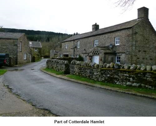
%20Part%20of%20Cotterdale%20Hamlet.jpg)
%20Old%20Beacon%20Tower.JPG)
Walk through the hamlet and
follow the stream until you get to the wooden bridge (the second bridge) (SD
833943). Turn right where a finger post indicates the bridleway route for
“Hardraw 3¾ miles” and
“Jinglemea Bog 1¼ miles”.
You enter Cotterdale Woods,
part of High Abbotside Moorland Regeneration Project. Just here are some
picnic tables where you might enjoy your sandwiches! Climb the path and when
you reach the broad forestry track, turn left.
Follow this track as it
zig-zags, rising through the trees. Fingerposts confirm your direction.
As you exit the trees, keep
straight ahead on the obvious broad grassy track. Cotterdale is below you to
the right and on the hill to the left above you is the old beacon tower.
After about ¾ mile, you reach
a fingerpost on the right (SD 847932) which indicates you are joining the
Pennine Way (for a short distance). Follow the fingerpost indicating
“Hardraw 1¾ miles”, bearing right through a gateway.
As the path descends, there are
good views down Wensleydale and Ingleborough can be seen in the distance.
Pass and ignore a fingerpost on the right for Cotterdale.
At a threeway fingerpost, turn
right, still following the Pennine Way.
%20Storm%20Clouds%20over%20Wensleydale.jpg)
After passing through two gates
across the track which form a sheep pen, at a fingerpost on the right for
New Bridge (SD 859919) turn right and head for the bottom left hand corner
of the field where there is a ladder stile.
Over this stile, descend the
steep grassy slope and look out for a threeway fingerpost, probably slightly
to your left. Follow the direction for Appersett. A series of posts with
somewhat faded footpath arrows mark the fairly obvious path.
You soon come in sight of the
two bridges at Appersett.
As you enter the last field
before the road, with a stone barn, the small gate into the road is not easy
to spot in the stone wall. Head for the collection of road signs and you
will see it.
If you need to buy any
hiking equipment/clothing before your trip see the Hiking
Store
All information on this
site is given in good faith and no liability is accepted in respect of any
damage, loss or injury which might result from acting on it.
|


.jpg)
.jpg)
.jpg)