|
Todmorden
to Bride Stones
Starting point and OS Grid reference:

Todmorden
Leisure Centre car park (SD 928248)
|
Ordnance Survey Map
OL21
- South Pennines.
Buy this map from
List
of OS Maps
Note: If you use OS Maps on-line, you can download this route via this
link.
| |
Distance:
7 miles
|
Date of Walk:
12
September 2014
| |
Ascent:
Descent:
See Walking Time Calculator
|
1342ft (409m)
1338ft (408m)
| |
Traffic
light rating: 

(For explanation see My
Walks page)
| |


For advice on .gpx files see
My Walks page
|

Click
the PDF logo above to give a printable version of this walk without the
photos.
|
To
view route as a dynamic Ordnance Survey map click here.
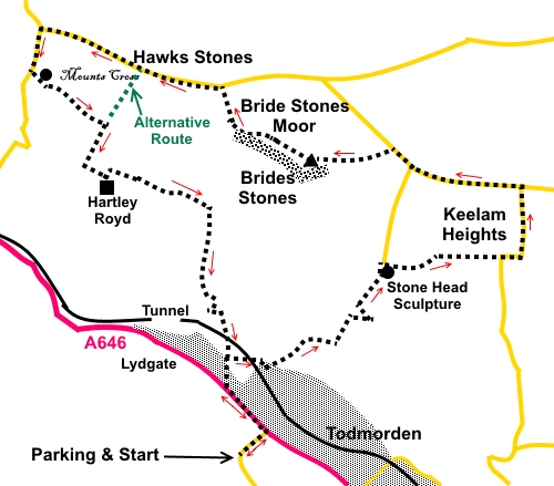
Introduction:
This walk from Todmorden to Bride Stones takes you up the northern
slopes of Calderdale providing good views of Calderdale itself and the South
Pennines. There are a number of interesting things to see en route, not
least the gritstone rocks eroded into unusual shapes on Bride Stones Moor.
Although a trip along the
bottom of Calderdale may not be particularly inspiring, once you gain a
little altitude, it seems to take on a whole new beauty. Unfortunately, it
was somewhat hazy when I did the walk, so the photos do not do it justice.
The rocks on Bride Stones
Moor are considered by climbers to be excellent bouldering territory and you
will probably see their white chalk marks left on hand holds, if not
climbers themselves. The Bride Stone itself seems to defy gravity. There was
at one time a “Groom” as well but this toppled over long ago and now
lies alongside. No doubt, sooner or later, the Bride will meet the same
fate, so perhaps hurry!
The route passes an unusual stone carving of a head of relatively recent vintage, reminiscent of an Easter Island statue and the ancient carved Mount Cross. The head is believed to have been carved in situ by William Holt of Todmorden (1897-1977), something of a flamboyant eccentric and polymath, who wrote a novel, The Wizard of Whirlaw, hence the statue. The cross dates from somewhere between the 7th and 11th centuries and is in quite good condition, considering its age and exposed location. It is believed to be the oldest religious monument in the area.
There is some road walking.
Mostly the roads are quiet but there is one section along Kebs Road where
the road is not especially busy but what traffic there is, moves quickly.
The start and finish involves a quarter of a mile along the busy A646 but
there is a pavement.
There are no refreshment
facilities en route and the best place for a picnic stop is at Bride Stones.
The walk starts from
Todmorden and there is ample free parking at the Todmorden Leisure Centre on
Ewood Lane or off the A646 immediately opposite Ewood Lane. To get there,
take the A646 west out of Todmorden town centre and take the first left
after Centre Vale Park. From the Burnley direction, turn right where
signposted for the Leisure Centre.
Start:
From the Leisure Centre, return to the A646 and turn left.
Follow the main road for
about a quarter of a mile and turn right along Stoney Royd Lane, marked with
a public bridleway sign. At the end of the houses on the right, turn right
along the narrow footpath. Follow this up and over the railway.
The footpath opens into a
residential cul-de-sac. Follow it to the road junction and turn left.
Follow the broad track
uphill and when it turns sharp left, leave it to continue straight ahead,
following the wall on the right (SD 932255). At the farmyard, go straight
through it and continue up the hill, following the right hand boundary of
the field. Where the fencing gives way to a wall heading up to the trees,
turn right through the old gateway. The route, right, across the hill looks
obvious but the one most clear at the time of my visit was little more than
an animal track and I believe the route should follow what amounts to a
shallow depression, more to the left (SD 932256).
%20View%20to%20Bride%20Stones%20Moor.jpg)
%20View%20along%20Calderdale.jpg)
Continue up the hill and as
you climb, look out for a wooden construction, possibly a dilapidated stile
which provides clearly a deliberate gap in the barbed wire fence. This is
not easy to spot. Cross this but not the shallow ditch immediately after it.
Instead, continue climbing, following the left hand side of the ditch. The
route curves left.
You should see the remnants
of a barn. Keep to the right of this. On joining a broad track, turn right.
Follow it to the farmhouse then turn left on another broad track (SD
936257).
Follow the track, then the
field, heading for the top right hand corner. Cross the stile then turn
right along the walled lane, noting the carved stone head (SD 937261). On
the horizon, to the right (SW) you can see Stoodley
Pike.
%20Stone%20Carving.jpg)
%20View%20to%20Stoodley%20Pike.jpg)
Stay on this track,
ignoring a track off to the right until reaching a road (SD 945261). Along
the way, you walk along some ancient stone paving.
At the road, it was my
intention to take a path off left from the corner, as shown on the OS map
but its position on the ground was obscure so instead, I stayed on the road
straight ahead, following it as it curved left. As it happens, there were
lovely views from the road. At the road junction (SD 946266), turn left.
Continue along the road for
just over half a mile, passing a “No Through Road” on the left. No more
than 200 yards after this junction, turn off the road on the left, through a
walkers gate on to Bride Stones Moor. The stones are clearly visible. Head
for the rocks on the obvious path. The white trig. point on top of the
stones soon becomes clear. As you get near, you will see “The Bride”. It
is worth spending a little time looking round the rock formations.
%20Approaching%20Bride%20Stones.jpg)
%20The%20Bride.jpg)
%20View%20NE%20from%20Bride%20Stones.jpg)
%20Rocks%20and%20Trig%20point.jpg)
%20Trig%20Point%20at%20Bride%20Stones.jpg)
%20Rock%20Formation%20at%20Bride%20Stones.jpg)
%20Calderdale%20view%20from%20Bride%20Stones.jpg)
%20Rock%20Formation.jpg)
The route continues NW (297°)
from the trig. point and on reaching a broad track, turn right to the road
then turn left. It is this section of road where speeding traffic has to be
watched for.
You now have to decide
whether to complete the whole walk, including Mount Cross. If you want to
shorten the walk and omit Mount Cross, continue along the road for about a
third of a mile. Turn left at Sagar Lane (SD 921273). This opposite some
impressive stone crags on the right (Hawks Stones) and marked with a public
bridleway sign. There is also an unusual red and white “fingerpost”
sign, showing New Brighton to the left and Liverpool to the right (I
didn’t understand it either!). Follow the bridleway for about a quarter of
a mile, rejoining the rest of the route at (SD 919270).
%20Hawks%20Stones.jpg)
To see Mount Cross, stay on
the road for a further half mile after Sagar Lane and turn left at the
junction down Mount Lane. After about 300 yards, opposite Lower Mount Farm,
turn left following the public bridleway sign.
You quickly pass Mount
Cross in a field to the left (SD 915273).
%20Mount%20Cross.jpg)
Follow the track as it
diverts around the farm and at a cross roads of tracks, turn right,
following the fingerpost for “Public Bridleway” and “Bluebell Lane”.
At the next junction of bridleways, by the farm, turn left.
You arrive at an impressive
stone farmhouse Hartley Royd. This Grade II listed building was built early
in the 17th century.
%20Hartley%20Royd.jpg)
By all means have a look at
the house – a public footpath runs through the yard. However, to continue
our route, do not pass the farmhouse but instead, turn left, through a gate
then almost immediately right.
Cross the beck (Redmires
Water) and keep straight ahead, following the yellow arrow direction, across
Hudson Moor. At the next junction, turn right down the walled track. Follow
the track for about 250 yards until just over a beck, then, turn right down
a narrow footpath through the heather (SD 926264). This path is easy to
miss. It follows the course of the beck now on your right, downhill.
%20View%20East%20along%20%20Calderdale.jpg)
When the path joins a broad
track, turn right.
You will recognise the
point on the outward journey, where you turned right off Stoney Royd.
Retrace your steps to the car park.
If you need to buy any
hiking equipment/clothing before your trip see the Hiking
Store
All information on this
site is given in good faith and no liability is accepted in respect of any
damage, loss or injury which might result from acting on it.
|


.jpg)
.jpg)
.jpg)