
|
|
|
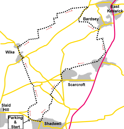
To view route as a dynamic Ordnance Survey map click here. Introduction: This walk is a gentle ramble from Shadwell on the outskirts of Leeds to the village of Bardsey. There are some pleasant views on the way, notably of the wide “East Keswick valley” (for want of a better name) from Wike Ridge. Unfortunately I did not see the walk at its best due to early mist. Bardsey’s full title is Bardsey-Cum-Rigton and claims a couple of “oldest in the country” records in respect of All Hallows church, with a tower allegedly going back to somewhere between 850 and 950 AD and the Bingley Arms, recorded in the Domesday Book. Whatever the age of the pub, I can highly recommend it for its food and beer. The walk progresses through Scarcroft, with no particular claim to fame, other than having some of the most impressive and expensive houses in the area. There are a lot of tarmac lanes in this area and so some road walking is required. However, traffic is light. As a convenient landmark, the Red Lion pub in Shadwell is the start for the walk. Access to Shadwell is most easily described from the Leeds Ring Road (A6120). Just east of the junction with the A61, at traffic lights, turn north on to Shadwell Lane, signposted for Shadwell and Wike. After just over a mile, at the somewhat confusing, traffic light controlled crossroads, take the half right turn continuing on Shadwell Lane. The Red Lion is on the right after almost three quarters of a mile. Park on the main street, trying to leave the area in front of shops for shoppers. Start: As if exiting the Red Lion car park, turn left and after a couple of hundred yards, right along Holywell Lane. After two hundred yards, as the tarmac lane bends sharp left, turn right along the signed public bridleway (SE 339401). As you get to a junction of tracks by the house High Trees, turn left, again following the public bridleway sign (SE 342404). Follow the track as far as Hall Farm and then turn right and immediately left to reach a road. Turn left and immediately right along the public bridleway (Brandon Lane on the OS map). At the road, turn briefly right then left along Forge Lane. Continue along the road until it starts to sweeps left. Turn right following the public footpath fingerpost (SE 335424). The path opens into Wike Ridge Golf Course. Keep to the left hand boundary. At the end of the fairway, in the left hand corner is a post with a faint arrow marking the path. Follow it down to the third lake, passing two others, one to the left and one to the right.
The path goes clockwise part way round this third lake, before turning left over a footbridge. After rounding a corner and just after passing under some power lines, turn left over a stile and follow the fence on the left, until you reach another stile. Cross this and turn right. Within a few yards, turn left over another stile after crossing a broad track (SE 343427). Follow the right hand boundary of the field. Pass through the farmyard of Biggin Farm and opposite the end of the farmhouse, turn right along the broad track. A two way fingerpost soon advises that you are following the Leeds Country Way. There are good views along here, to the north.
After going through a gate, follow the left hand side of the field and at its end, turn left once more following the Leeds Country Way sign. The path turns right running parallel with the broad valley on the left. Continue to follow it as it bears left, slightly downhill into the valley. When the track forks, keep right and follow the bridleway to the road and turn right (SE 360437). Stay on the road for around a third of a mile and look out for a fingerpost on the left Cross the stile and walk anti-clockwise around the edge of the field until you reach a stile. Cross this to follow the clear footpath, along the course of Gill Beck. On joining the tarmac at Quarry Hill Farm, turn left along it. Arrive in Bardsey opposite the Bingley Arms. The route continues up the right hand side of the pub, along a narrow, tarmac footpath, becoming a broad tarmac drive, passing Hill Cottage. When the track forks (SE 363426), by a small pond, keep left. There is a convenient bench here if you want a picnic lunch. On rejoining the Leeds Country Way, turn right (SE 365 426). Follow it to the road but a few yards before reaching it, turn right to follow a footpath running parallel with the road. On reaching the road at Scarcroft, turn right along it (Syke Lane) (SE 363418). Follow the road for almost a mile, passing Scarcroft Golf Course, until it reaches Bay Horse Lane. Turn left until you reach a crossroads. Here, turn right and immediately left to leave the road and follow a public footpath fingerpost. Head for the diagonally opposite corner of the field, cross two stiles in quick succession, then follow the left hand field boundary. At the road, cross straight over to follow the footpath alongside the nursery. After going through a wooded area, arrive at a road and turn left. After a hundred yards, by a house called The Old Stables, turn right to follow a public footpath fingerpost. Cross the field and go over a footbridge, then follow the path up the right hand side of the field. Cross one stile, then another marked with yellow tape.
Go through two gates and then follow the left hand boundary of the field. You soon join a lane which leads to Shadwell’s main street. Turn right back to the car. If you need to buy any hiking equipment/clothing before your trip see the Hiking Store All information on this site is given in good faith and no liability is accepted in respect of any damage, loss or injury which might result from acting on it.
| | |||||||||||||||||

.jpg)
.jpg)
.jpg)
%20View%20across%20Wike%20Ridge%20Golf%20Course.jpg)
%20Lake%20at%20Wike%20Ridge%20Golf%20Course.jpg)
%20View%20Over%20The%20East%20Keswick%20Valley.jpg)
%20View%20to%20East%20Keswick.jpg)
%20Almost%20back.jpg)