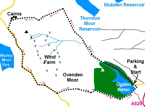
|
Ovenden
Moor
Circuit
Starting point and OS Grid reference:

Car
park at Ogden Water (SE 066309)
|
Ordnance Survey Map
OL21
- South Pennines.
Buy this map from
List
of OS Maps
Note: If you use OS Maps on-line, you can download this route via this
link.
| |
Distance:
6
miles
|
Date of Walk:
12 January 2012
| |
Ascent:
Descent:
See Walking Time Calculator
|
635ft (193m)
635ft (193m)
| |
Traffic
light rating:  

(For explanation see My
Walks page)
| |


For advice on .gpx files see
My Walks page
|

Click
the PDF logo above to give a printable version of this walk without the
photos.
|

To
view route as a dynamic Ordnance Survey map click here.
Introduction:
Ovenden Moor sits above Denholme to
the west of the A629 between Halifax and Keighley. It is home to Ovenden
Moor Wind Farm with over 20 white wind turbine electrical generators which
can be seen from miles around. This is a walk of reservoirs and takes you on
a circuit of the moor plateau and provides for some remarkable long distance
views. The walk is mostly fairly level. Note that after wet weather, the
plateau can be very boggy and gaiters are recommended.
The walk starts at the car
park for Ogden Water (small charge). To get there, turn off the A629 next to
the Causeway Foot Inn for Ogden Water. The pub provides for good beer and
food. Public toilets are available at Ogden Water.
Start:
From the car park, proceed to the back corner by the trees and go through
the left hand of the gates and head down towards the water. At the junction
turn right and walk through the trees (there is a path at the water’s edge
if you prefer).
%20View%20over%20Ogden%20Water.jpg)
On reaching the path at the
water’s edge, turn right and follow it until you reach the bridge over the
beck but do not go over it. Instead, follow the footpath alongside the right
hand side of the beck. You will pass more footbridges but stay on the right
of the beck passing a number of waterfalls.
%20Beck%20Feeding%20Ogden%20Water.jpg)
On reaching a small dam (SE
052321), fork off to the right on to a much fainter path, climbing the bank.
At the top of the bank, turn left and follow the broad track.
%20View%20over%20Thornton%20Moor%20Reservoir.jpg)
Shortly after coming in
sight of Thornton Moor Reservoir, go through a kissing gate on the left (SE
047330). Continue to follow the main track round the edge of the plateau.
There are great views north over Leeming Reservoir.
%20View%20over%20Leeming%20Reservoir%20and%20Oxenhope.jpg)
Head for the large stone
cairns you will see on Nab Hill at the edge of the plateau (SE 033327).
Continue to the road and turn left (SE 032325). Here are good views across
Warley Moor Reservoir with Stoodley
Pike above Hebden Bridge in the distance.
%20Cairn%20at%20Nab%20Hill.jpg)
%20Ovenden%20Moor%20Wind%20Farm.jpg)
Walk along the road past
the wind turbines and the information board and at the next building on the
left, turn left (SE 045307). The footpath sign is not easy to see behind the
house. The route becomes an unusually wide stony track. Follow this down
alongside the trees and across the dam to return to the car park. There are
good views over to Halifax along this track.
%20Looking%20towards%20Halifax.jpg)
If you need to buy any
hiking equipment/clothing before your trip see the Hiking
Store
All information on this
site is given in good faith and no liability is accepted in respect of any
damage, loss or injury which might result from acting on it.
|
