
|
|
|
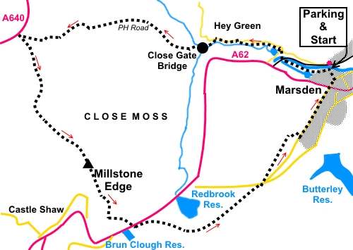
To view route as a dynamic Ordnance Survey map click here. Introduction: This circular walk from Marsden takes you across Marsden Moor following part of an old packhorse route. This was the subject of a dispute at the beginning of the 20th Century between The Lord of the Manor, Sir Joseph Radcliffe, who claimed there was no right of way across his grouse moor and the Urban District Council. After a court case in 1906, the Right of Way was established and a number of stones inscribed “PH Road” were set out along the route. You will see some of the survivors. The moor is now owned by the National Trust. The walk starts along the Huddersfield Narrow Canal at Marsden, turning off at the eastern end of Standedge Tunnel, the longest canal tunnel in Britain at 3¼ miles. You will see the tunnel entrance. Trips can be arranged along it and there is a café there. The walk takes you along the grit-stone edge of the appropriately named Millstone Edge from where there are expansive views to Castleshaw Reservoir and Lancashire. Millstone Edge is rightly named, a hard edge of weathered grit-stone and tumbled boulders, the ground drops steeply down in a broad sweep to the Castleshaw Reservoirs below. The return leg provides good views over Marsden and down the valley. The walk is ideally suited to public transport as Marsden is situated on the main A62 between Huddersfield and Oldham and well served by buses. Marsden also has a railway station from where the walk starts. For car parking, follow signs for the station. Turn right off Station Road in front of the station, to follow the car park sign. Continue past the National Trust office to where there is an extensive free parking area. There are no facilities en route other than at Tunnel End. Start: Join the Huddersfield Narrow Canal in front of the station (SE 046118) and walk west along the towpath passing the locks. Follow the towpath for about a third of a mile and cross the canal by the bridge (SE 040120), which overlooks the eastern end of the Standedge Tunnel.
Just after crossing the bridge, take the path across the field leading from the right hand corner of the roadside parking area. Follow it to a road, cross straight over and follow this path. It follows the beck which feeds Tunnel End Reservoir and emerges in Waters Road. Turn left. Pass Hey Green House (notable for having the first electrically powered house in the Colne Valley c.1890. A blue plaque commemorates) and continue along Blake Lea Lane. Just before Eastergate Cottage, fork left on to a footpath, indicated by an old metal footpath sign. The path follows the right hand bank of a stream.
Follow the path to Close Gate (or Eastergate) Bridge. Cross and take the broad track to the right, following the left hand bank of the stream.
When the path splits, take the left hand path, following the yellow arrow, climbing away from the stream. Here and there, the path is “manicured” with Yorkshire Stone slabs. You now follow this clear path across the moor for almost two miles. It is along this section that you will see a number of posts marked with “PH Road”.
On reaching the road (SE 002123), the A640, do not join the road but turn sharp left, almost going back on yourself, to follow a footpath sign for “Standedge and Edale via the Pennine Way”. It starts as a boardwalk then becomes a gravel track. You quickly arrive at Millstone Edge with views across to Lancashire and Castleshaw Reservoirs. Turn left to follow the top of the edge, along the obvious path, passing a trig. point at SE 012104.
At a kissing gate, turn left to follow a broad track. As you draw level with the end of the reservoir, the track splits. Fork right following the Pennine Way fingerpost. When you get to the car park at Brun Clough Reservoir, turn left along the path following the Pennine Way fingerpost. As you draw level with another reservoir (Redbrook Reservoir), the path forks. Fork left for Marsden. The path follows a small valley joining the road at SE 037101. Turn briefly right, then left at the fork on to Old Mount Road. Immediately bear left on to the track for Hades farm, which saves walking on the road.
Continue along the track along as it follows a wall on the right. When the wall dips down, turn off right to follow a yellow footpath arrow. Follow the path for about 150 yards, then turn right again to take a path between a fence and a wall. At the road, turn left to return to Marsden. At the crossroads, go straight over along Towngate and follow it as it curves left passing St Bartholomew’s Church and at Station Road, turn left to return to the car park/station. If you need to buy any hiking equipment/clothing before your trip see the Hiking Store All information on this site is given in good faith and no liability is accepted in respect of any damage, loss or injury which might result from acting on it.
| | |||||||||||||||||

.jpg)
.jpg)
.jpg)
%20Along%20the%20Huddersfield%20Narrow%20Canal.jpg)
%20Tunnel%20End.jpg)
%20Ornate%20gate%20on%20Waters%20Road.jpg)
%20Closegate%20Bridge.jpg)
%20Beck%20beyond%20Closegate%20Bridge.jpg)
%20NT%20marker.jpg)
%20Looking%20back%20towards%20Marsden.jpg)
%20Looking%20towards%20Slaithwaite%20Moor.jpg)
%20Part%20of%20the%20manicured%20path.jpg)
%20PH%20Road%20Marker.jpg)
%20View%20to%20Castleshaw%20reservoirs.jpg)
%20Rocks%20at%20Millstone%20Edge.jpg)
%20Rocks%20at%20Millstone%20Edge.jpg)
%20Trig%20point.jpg)
%20Butterley%20Reservoir.jpg)
%20Marsden.jpg)