
|
|
|
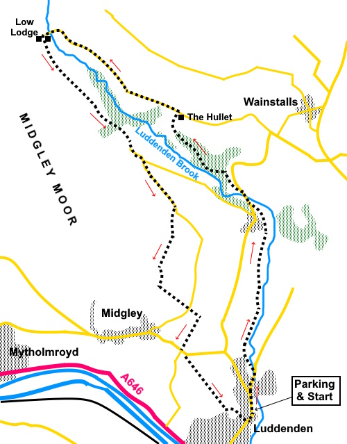
To view route as a dynamic Ordnance Survey map click here. Introduction: This is an easy, picturesque walk which gives you a ‘balcony’ view around the pretty Luddenden Valley in Calderdale. It starts in the historic village of Luddenden which is believed to date back to Anglo-Saxon times. The name had evolved from Ludd-ing-Dene which means settlement or clearing (ing) in the valley (Dene) of the Ludd (or loud river). The river was crossed by a ford until 1518 when a bridge was built. The Industrial Revolution brought several mills to the village but as is so often the case, eventually they became unprofitable and have now been turned into apartments. Many of the houses in the town date back to the 17th Century and many are listed. The whole village is a conservation area. Luddenden was hit by the Black Death in 1379. Around 40% of the population of the village and the valley died. About halfway through the walk, you will pass through the impressive gatehouse Low Lodge on Catherine House Lane. It was the gatehouse to Castle Carr, a grand shooting lodge built as a mock Norman castle between 1859 and 1871. It was demolished in 1962. The route passes through some deciduous woodland where long tailed tits, jays, redwings, fieldfares and woodpeckers may be seen, depending on the time of year. The woods are also home to a variety of flora including wood anemones and bluebells. I imagine the woods are also attractive when adorned with Autumn colours. There
are no facilities en route though there are a number of benches on the first
half of the walk if you want a picnic stop, a particularly good one with a
great view being on Heys Lane. Close to half way round the walk (SE 031229). Overall.
It is an easy walk with little ascent and straightforward navigation. The walk
starts from the Millenium car park in Luddenden. To get there, turn north
off the A646 between Halifax and Mytholmroyd, up Luddenden Lane. It does not
seem to be signposted but look out for the blue warning signs about it being
unsuitable for heavy and long vehicles, steep gradients and sharp bends. The
car park is on the right after half a mile. It can be accessed from the north from Illingworth but be prepared for the very steep decent, very tight turns and probability of having to do some backing up, especially on the outskirts of the village. Start: Exit the car park (SE 042257) and turn right. The road soon forks. Take the right hand arm along High Street.
Continue to follow the High Street until just over 300 yards later, the road forks again. Go left to remain on High Street and cross the stream.
Pass St. Mary’s church and turn right up a cobbled section. You will soon see a footpath off to the right, just in front of some four storey houses. The path opens into a broader track which follows Luddenden Brook. You follow it for quite a way.
You reach a fork where the right fork goes over a bridge but ignore this and stay on the main track left. Pass a long row of terraced houses and continue on the broad track.
Reach
a road (SE
042268) and turn right along it. As it bends right, fork left on a drive
signposted for Jowler Mill and after a few yards, turn left into the woods,
passing an information board about wildlife in the Luddenden Valley.
The path
drops down to a footbridge which you cross then pass another information
board about White Clawed Crayfish at Jerusalem Farm. Keep straight ahead
here over a brief section, ‘cobbled’ with some rough stones.
When the
path forks (SE 037280), take the right hand fork, climbing steadily. Follow
the clear path until it turns abruptly right at a stone house with a large
conservatory (The Hullet). Follow its drive to the road and turn left. The
road is Heys Lane.
Follow
the road for almost a mile. There are good views along here. After a mile,
reach Low Lodge, spanning the road with an arch. Pass through and continue
on the drive beyond.
Follow
the drive until it turns right, at which point keep straight ahead passing
Catherine House Farm (SE 025288). Keep following the main track, ignoring
any turns off.
The track becomes a tarmac lane. When it forks (SE 031279), take the right fork. Ignore a right turn for Clough Lane which you reach a little further on.
At the
next junction (SE 035275), turn right briefly along the road, then left to
Height Farm. There is another information board here about wildlife in the
valley. Keep a look out for a public fingerpost on the right. Do not turn here but continue along the track for a few more yards. Just before the track turns into Height Farm, turn right over a stile marked with a yellow arrow, then turn left along an obvious path.
Continue
to follow this clear path, ignoring any turns off. Reach a
walkers’ gate marked with a yellow arrow and follow the path downhill
beyond it. The path
joins a tarmac and later concrete drive, eventually joining.Radcliffe Lane. Follow
Radcliffe Lane downhill. At the road, cross over and follow the wide track
beyond. It curves right and becomes tarmac, between two high stone walls.
Ignore a path off to the left. At the
bottom of the lane (Pin Hill Lane), turn left along the road for fifty yards
or so. Look out for a cream painted house on the right and turn right here.
There is a sign indicating a football pitch along here. Follow
this lane, going through as metal gate marked with a yellow arrow, ignoring
the right turn indicated with a blue bridleway arrow. Follow
the track down and turn sharp left at the next junction, to walk clockwise
round a house with tall, cream painted chimneys, to find the continuation of
the route downhill. The
footpath becomes a tarmac lane beside some houses. Follow it down to the
main street through Luddenden and turn left to reach the car park. If you need to buy any hiking equipment/clothing before your trip see the Hiking Store All information on this site is given in good faith and no liability is accepted in respect of any damage, loss or injury which might result from acting on it.
| | |||||||||||||||||

.jpg)
.jpg)
.jpg)
%20Old%20quarry%20winding%20gear%20in%20Luddenden.jpg)
%20Luddenden%20Brook.jpg)
%20Looking%20back%20along%20the%20track%20from%20Luddenden.jpg)
%20Row%20of%20Stone%20Cottages.jpg)
%20First%20view%20of%20Luddenden%20Valley.jpg)
%20Footpath%20Through%20the%20Woods.jpg)
%20Looking%20across%20the%20Luddenden%20Valley.jpg)
%20View%20down%20the%20Luddenden%20Valley.jpg)
%20Luddenden%20Brook%20at%20Low%20Bridge.jpg)
%20The%20Gatehouse.jpg)
%20View%20back%20to%20the%20head%20of%20the%20valley.jpg)
%20View%20across%20the%20valley.jpg)
%20View%20NE.jpg)