
|
|
|
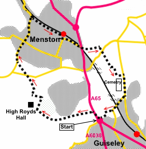
To view route as a dynamic Ordnance Survey map click here. Introduction: Although ordinarily there would be a little too much road walking for me on this route, it nevertheless makes for a pleasant couple of hours ramble and has the benefit of some remarkably pretty views. If you can time the walk appropriately (probably April/early May), you will also see one of the best (and probably least known) bluebell displays in the area. This walk takes in a circuit through the outskirts of Guiseley and Menston. An added bonus is that there is the opportunity for a refreshment break at any one of three pubs! The walk is also ideal to be done using public transport as buses run from Leeds, Bradford and Otley past the White Cross roundabout. The roundabout is also only about half a mile from Guiseley train station. As this is a circular walk, you could also start from Menston train station. As White Cross is a busy junction, car parking is a little more problematic but there are some nearby residential streets. Start: From the White Cross roundabout, head along north along the A65, in the direction of Skipton, for about three hundred yards. Ignore any footpaths off to the left. Turn first left at the first road junction (Guiseley Drive).
After about a hundred yards, as you come to the first black lamppost, just before a lake/pond to the right, turn left down the bank. Follow a well trodden footpath as it curves right. The path starts to follow a line of trees on the right. Ignore one or two paths which go through these trees. The paths forks (SE 174425). Keep to the left fork.
The line of trees starts to thicken to a more dense woodland but stay outside the woods until the path forks again, just before a fence, at the end of the woods (SE 171426). Fork right into the woods but keep to the path nearest the left hand edge. It is through the woods here that you can see the bluebell display, in the spring.
Look out for a gate on the left hand side which exits the woods and through this, turn right (there is a dilapidated building a short distance away as a reference point). As the path starts to descend, look out for a stile on the left over a fence. Cross this and follow the permissive path indicated by the fingerpost, along an avenue of trees. On reaching the broad drive to High Royds Hall after crossing another stile, turn right along the drive. Look out for a stile on the left after about a hundred yards. Cross this and follow the direction of the public footpath fingerpost, arriving at the road opposite a stone house. Turn left along the verge for a few yards, then turn right off the road to follow another public footpath fingerpost. Cross just to the right of the highest point of the field to arrive at a wooden stile. There are good views now across the Wharfe Valley and to Otley Chevin. On the far horizon is Almscliff Crag. Cross the stile and follow the direction of the yellow arrow. Cross another stile and follow the path to the trees.
Go through a squeeze stile on to the road (Derry Hill) (SE 167435) and turn right to Menston, arriving in the village centre by the Menston Arms pub. Cross Main Street and continue down Burley Lane until it bends distinctly left and there, turn right along Westbourne Drive. This starts off as a tarmac lane but gives way to a rougher unmade road. Continue to its end and at the road junction, turn left along Station Road, to its junction with the main A65 (Bradford Road). Cross carefully (there is a traffic light controlled pedestrian crossing to the right if traffic is heavy). Immediately opposite Station Road, take the footpath indicated by the public footpath fingerpost. The path crosses the railway line then bends right. Stay on it, crossing a footbridge over a stream, then up steps.
Go through a gate in the corner of a field and follow the left hand boundary. Exit the field through a walkers’ gate and go straight ahead to a ‘T’ junction of tracks and turn right (SE 181438). Go straight over at the road (Buckle Lane) and through a kissing gate, following the direction of the public footpath fingerpost. Ahead, are the remains of an old gateway and a slit stile and beyond, a dilapidated/collapsed stone wall. Keep straight ahead following this wall with it to your left. At the end of the field, go through a walkers’ gate and at this stage, aim slightly to the right of the house ahead. At the end of this next field, go through a somewhat ramshackle stile arrangement and head to the left of the farmhouse where there is a kissing gate on to its drive.
Follow the drive as it curves left and to the junction with the road (Chevin End Road) (SE 186433). Turn right along the pavement. As you progress, the impressive towers of the old High Royds Hospital, now apartments, are clearly visible. You pass Guiseley Cemetery, where there are some benches should you need a rest but it is worth venturing in a short distance, for the good views across to the moors.
Continue past the cemetery and turn right down Ings Lane, passing The Ings pub and crossing the railway line. As a matter of interest, “Ings” is an old Norse word relating to marshes or water meadows or possibly from “Ing”, an ancient Norse fertility god. In this location, the former seems more likely as there are a number of water courses which could have created water meadows and/or marsh. Around a hundred yards after the railway bridge, as it bends left, turn right along a footpath indicated by a fingerpost and passing a ruined farmhouse (SE 184427). Follow the right hand boundary and at the end of the field, turn left to follow the obvious path until it exits by the White Cross roundabout. If you need to buy any hiking equipment/clothing before your trip see the Hiking Store All information on this site is given in good faith and no liability is accepted in respect of any damage, loss or injury which might result from acting on it.
| | |||||||||||||||||

.jpg)
.jpg)
.jpg)
%20Pond%20at%20High%20Royds.jpg)
%20Heading%20towards%20bluebell%20woods.jpg)
%20in%20the%20bluebell%20woods.jpg)
%20In%20the%20bluebell%20woods.jpg)
%20Looking%20over%20Menston%20towards%20Otley%20Chevin.jpg)
%20Telephoto%20shot%20of%20Almsclif%20Crag.jpg)
%20Stream%20near%20Menston%20Station.jpg)
%20Footbridge%20over%20stream%20near%20Menston%20Station.jpg)
%20View%20towards%20Rombalds%20Moor.jpg)
%20View%20by%20Guiseley%20Cemetery.jpg)
%20Blossom%20at%20Guiseley%20Cemetery.jpg)