
|
|
|
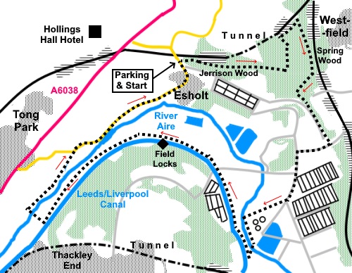
To view route as a dynamic Ordnance Survey map click here. Introduction: This walk from Esholt village takes you through attractive woodland, an extensive sewage works and along the Leeds/Liverpool canal. No, you did not misread that and I have not gone completely mad. Recalling the pleasant Calverley walk I did last year, not far away, I was looking for another woodland walk to enjoy autumn colours and I spotted Jerrison Wood and Spring Wood by Esholt village, on the Ordnance Survey map. I have been to the village before but never explored the woods. A study of the map revealed potential for a circular walk, which should be interestingly varied giving a pretty village, autumn colours and a canal and riverside walk. Oh, and the sewage works. Before
you decide to read no further, bear with me. Looking at the OS map, you can
see Esholt Sewage Treatment
Works is huge. Indeed, it is one of Yorkshire’s largest, serving
large sections of Leeds and Bradford. In fact its massive size means the
parts you go through/between are virtually invisible. The main view of it is
on a brief part of the canal section. The Esholt Sewage Treatment Works
began life in 1899 as a means of stopping sewage needing to be dumped into
Bradford Beck. I do not think development/expansion has ever stopped, as the
cities become larger. By the way, it did not stink! Esholt’s other claim to fame is
that if you go back enough decades, the village was used as the outside set
for the TV soap Emmerdale (or Emmerdale Farm as it was then). Despite the
long passage of time since then, the village ‘milks’ its media heritage
for all its worth, the pub having changed its name to that used in the
programme from the Commercial Inn. Its walls are adorned with portraits of
who I assume are Emmerdale ‘stars’ (I have never seen it). The Post
Office also sells Emmerdale souvenirs, according to a sign (whatever they
are!). Nevertheless, Esholt is an extremely attractive village with a rural oasis feel, despite its proximity to Guiseley and Baildon/Shipley. It is a conservation area and coupled with the Emmerdale factor, attracts plenty of tourists. It is worth spending a little time wandering about to see the Grade II listed 16th Century Old Hall and St Paul’s Church. I recommend leaving this until the end, then you can enjoy a pint at the Woolpack. The beer was very good! The walk along this section of the canal is very tranquil and you pass a three chambered staircase lock flight. The woods were very attractive with the autumn colours. The walk through them takes you to Guiseley Beck and the combination of the water and woods was lovely. The woods are popular, so there are various paths where people have made up their own routes. The covering of autumn leaves also made some of the paths quite hard to follow. I followed the Welcome Way route but the markers are tiny and easily missed. It would be worth having a compass with you and if you become disoriented, head north until you reach the boundary of the wood and follow it North-East until you reach Guiseley Beck, which is pretty much unmissable. I went a bit mad with the photographs! The walk starts from a pay and display car park. For some reason, this was barred off when I did the walk but there was plenty of on street parking. I do not know when/if the car park is open. The easiest way to get to Esholt is via the signposted turn off from the A6038 between Guiseley and Baildon. The car park is on the left immediately after passing under the railway viaduct. Start: If you have parked in the car park, the path into the woods leads out of its rear. If you have had to use the road, there is a short footpath on the village side of the car park entrance leading into the car park (SE 182405). Follow the path into the trees, soon crossing a couple of wooden bridges. At SE 186404, you reach a large boulder on the left of the path. Ignore the path off left immediately before this and go straight over a crossroads of paths immediately after it.
Just after passing under some power lines, the path forks. Fork left following a small black arrow on a round ‘badge’ nailed on to a tree, indicating the “Welcome Way”.
Not far after this, the path curves left. There is the hint of a fork but stay on the main track as it curves. You may spot another small ‘badge’ nailed to a tree on the right, this time with a yellow arrow, also indicating “Welcome Way”. The path crosses what is best described as a shallow muddy ditch (which I suppose could be dry or flowing depending on recent weather). Shortly after this, the path curves left and there is another, easily missed, black arrow. Continue roughly in the same direction until you see a dilapidated stone wall ahead. Just before you reach it, turn right downhill along a pretty clear path, following another yellow arrow. You should soon catch sight of the railway line as it emerges from Esholt tunnel. You can just see the tunnel if you get close up to the fence.
Continue downhill, ignoring any paths off into the trees, until you reach Guiseley Beck by a footbridge (SE 191408). Turn right here to follow the right hand bank of the beck. This is where you leave the Welcome Way which goes left over the footbridge.
When you get to a large black pipe crossing the beck, turn right up the banking to join a broad clear path and turn left. Follow this path until you reach a bridge with a parapet on its left. There is a large concrete square construction, no doubt connected with water works. Do not confuse this bridge with an earlier one of lesser stature! You could perch on the concrete for a picnic.
Cross the bridge (SE 193404), passing between two stone gateposts and turn right. Follow the descending track until it forks by a large stone post on the left. Turn left here. The track starts to climb slightly. Just after going between two short sections of stone wall, turn right off the cobbled track. You will notice woodland gives way to field on the left. Look out for a path on the right through the trees. Meet a path at a ‘T’ junction and turn left. You should be well above a broad muddy track below you on the right. Join a broad track and turn left. When your way is barred by a substantial metal fence, turn right (SE 194398). The footpath becomes tarmac and you follow this down to cross a substantial metal stile on to a tarmac lane where you turn left.
Pass Home Farm Business Park and quickly reach a wide lay-by. Take the footpath which leaves the lay-by on its left, by a large gatepost (SE190393). The path leads you to the bank of the River Aire. Turn left.
After about two hundred and fifty yards, cross the river via a suspension bridge. Once over it, continue straight ahead, ignoring a footpath off to the left.
The path soon leads to some rough steps which you climb, over the embankment, to meet the Leeds Liverpool canal. Turn right along the towpath. To the left is a swing bridge and there is a low wall by it, at the other side of the canal which could provide a perch for a picnic, though you might have to move should any boaters need to swing the bridge!. You are heading in the Shipley direction, passing extensive sewage works and soon reach Field Locks (SE 180398).
Just over three quarters of a mile after the locks, you reach another swing bridge with the number 211. Turn right here, off the towpath.
Descend a cobbled path to reach a long footbridge to re-cross the River Aire and turn immediately right to follow its left hand bank (SE 189392).
After less than half a mile, reach the road and turn right back to Esholt. However, before reaching the car, it is worth a right turn in Esholt, down Church Lane, to see the old hall and St Paul’s Church. The Woolpack pub may provide a refreshment opportunity!
If you need to buy any hiking equipment/clothing before your trip see the Hiking Store All information on this site is given in good faith and no liability is accepted in respect of any damage, loss or injury which might result from acting on it.
| | |||||||||||||||||

.jpg)
.jpg)
.jpg)
%20Autumn%20in%20Jerrison%20Wood.jpg)
%20Along%20the%20Welcome%20Way%20in%20Jerrison%20Wood.jpg)
%20View%20South%20West.jpg)
%20Merging%20into%20Spring%20Wood.jpg)
%20Esholt%20railway%20tunnel.jpg)
%20Arriving%20at%20Guiseley%20Beck.jpg)
%20Cascade%20on%20Guiseley%20Beck.jpg)
%20Route's%20crossing%20point%20for%20Guiseley%20Beck.jpg)
%20Substantial%20stile.jpg)
%20View%20to%20Dawson%20Wood.jpg)
%20Suspension%20bridge%20over%20the%20river%20Aire.jpg)
%20River%20Aire%20from%20the%20suspension%20bridge.jpg)
%20Reflections%20on%20the%20Leeds%20Liverpool%20canal.jpg)
%20Leeds%20Liverpool%20canal%20colours.jpg)
%20Field%20Locks.jpg)
%20Approaching%20swing%20bridge%20211.jpg)
%20Long%20footbridge%20over%20the%20River%20Aire.jpg)
%20Looking%20along%20Esholt%20Main%20Street.jpg)
%20The%20Old%20Hall,%20Esholt.jpg)
%20The%20Old%20Schoolhouse%20Esholt.jpg)
%20St%20Pauls%20Church%20Esholt.jpg)