
|
|
|
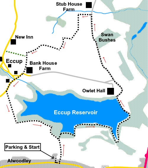
To view route as a dynamic Ordnance Survey map click here. Introduction: The walk round Eccup Reservoir is traditionally a straightforward circuit, along clear tracks. However my route misses out the northern section, effectively a road, in favour of a diversion through the countryside. The route is nevertheless easy to follow. There were some muddy sections, as I did the walk after a period of wet weather, so gaiters were the order of the day. Eccup Reservoir is in the Leeds suburb of Alwoodley. The first part of it was constructed in 1843, on land donated by the Earl of Harewood. It was then expanded in the 1850s and 1890s as Leeds grew. It is the largest area of water in West Yorkshire, covering some 91 hectares (220 acres). It has been designated as an Area of Special Scientific Interest (SSSI) due to the large variety of birds which overwinter there. There is also a good chance of seeing Red Kites as Eccup reservoir is close to Harewood House where many have been released. Close to the start of the reservoir section, is an impressive stone built, domed building. This is a pumping station because instead of extracting its water from the dam area, where extractions usually occur, it is extracted here. Winter is a good time to do this walk because much of the reservoir is surrounded by trees, between a fence and the water. When the trees are in leaf, the view would be greatly obscured. There are clear views from the dam area. After diverting from the reservoir, I noticed and photographed an attractive ‘hamlet’ nestling in a hollow. This is ‘Emmerdale’, the purpose built set that has been created for filming the external scenes for the TV series of that name. Previously it was filmed in Esholt, the village I visited on my Esholt Circular Walk. It was built in 1997. In theory, it is a temporary structure as it is on green belt land. Its initial permissions allowed for ten years but this has obviously been extended. The route then curves round to the tiny hamlet of Eccup. There is not a great deal there but just outside the hamlet is the New Inn pub, should you fancy refreshment. Check opening hours. There is no parking at the reservoir itself. You can park on Alwoodley Lane which is very wide but busy. I parked in Lakeside Drive, which is off Alwoodley Lane in Leeds and next to the approach drive to the reservoir path. To get there, leave the A61 at the traffic lights at Alwoodley Gates in the direction of Adel. Lakeside Drive is on the right after a mile. Alternatively, leave the Leeds Ring Road at the King Lane roundabout, heading north on King Lane in the direction of Alwoodley. After 1.4 miles, turn right on to Alwoodley Lane. Lakeside Drive is third on the left. Start: From Lakeside Drive, turn left along Alwoodley Lane for a few yards then left following a public footpath fingerpost, along a tarmac lane (Goodrick Lane) (SE 297408). Reach a ‘T’ junction (ignoring a public footpath off to the right by the golf course) at an attractive double fronted cottage and turn right (SE 297413). All you have to do now is follow this broad track round the reservoir, to the dam.
Cross the dam and continue along the tarmac lane passing Owlet Hall, now converted to two (I think) residences. Ignore any turns off to the left and continue along the lane. At a junction, turn left following the cycle way sign, still on the broad tarmac lane.
Continue along the lane until you come to a Public Bridleway sign on the right, just past the water treatment works. Turn right along this track (SE 306423).
Follow this track for three quarters of a mile. A couple of hundred yards before Stub Farm turn left opposite a notice welcoming you to the Harewood Estate and a sign for the Leeds Country Way (SE 303434).
Follow the obvious path for about one and a quarter miles. It ‘kinks’ a few times but is obvious on the ground and there are no turns off, until almost at the end of the section where there is a path across to the road, exiting close to the New Inn, should you wish to avail yourself (indicated on the sketch map). Exit the footpath via the concrete access to Bank House Farm and turn right at the road. There is a bench along here should you be looking for a picnic spot. At the junction with Village Road at Eccup, fork left. After a few yards, ignore a narrow lane off to the right, keeping straight ahead. Not far after a lay-by on the right, the road bends slightly right. Take the footpath over the stile by two sets of gates, marked with a yellow footpath arrow (SE 288421). The path follows the hedge on the right. When the hedge turns sharply right at a corner, keep straight ahead, heading for the right hand side of the small wood ahead. Cross the stile there. All you then need to do is turn left at the corner and stick to the edge of the wood. This will return you to the double fronted cottage passed at the beginning of the walk, where you turn right to retrace your steps to the car. If you need to buy any hiking equipment/clothing before your trip see the Hiking Store All information on this site is given in good faith and no liability is accepted in respect of any damage, loss or injury which might result from acting on it.
| | |||||||||||||||||

.jpg)
.jpg)
.jpg)
%20Attractive%20cottage%20as%20reservoir%20is%20approached..jpg)
%20Outlet%20works%20at%20Eccup%20Reservoir.jpg)
%20Eccup%20Reservoir%20through%20the%20trees.jpg)
%20Track%20along%20the%20south%20side%20of%20the%20reservoir.jpg)
%20View%20down%20the%20reservoir%20from%20the%20dam.jpg)
%20View%20along%20the%20dam.jpg)
%20View%20across%20open%20countryside%20from%20the%20dam.jpg)
%20Countryside%20view%20after%20leaving%20Eccup%20Reservoir.jpg)
%20Emmerdale.jpg)
%20Ruin%20Near%20Stub%20Farm.jpg)
%20Rolling%20countryside%20en%20route%20to%20Eccup%20hamlet.jpg)