
|
|
|
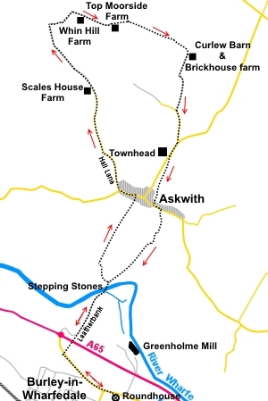
To view route as a dynamic Ordnance Survey map click here. Introduction: This walk is a very relaxing walk, mostly along very well defined tracks, which makes for easy navigation. It has the bonus of providing a refreshment opportunity at the Askwith Arms pub in Askwith, where a “Walkers Are Welcome” sign is displayed. At various points there are great views south across and along the Wharfe valley and NW to Beamsley Beacon. Various wild flowers can be seen, especially along Hall Lane out of Askwith and there is a good chance of sight of red kites and curlews. This walk crosses Burley-in-Wharfedale’s stepping stones across the River Wharfe. It must be emphasised that these stones are only exposed when the river is low. The Wharfe rises (and falls) very quickly, so after any kind of major wet spell, they are likely to be under water. In these circumstances, do not attempt a crossing. At best the stones will be slippery and you will probably get wet. Worst case, you could be swept away! There is a long running campaign by the Burley Bridge Association to have a bridge constructed here. At the bottom of the page is a real time gauge indicator of the river level at Ilkley, some 4 miles upstream. This will give some indication of the likelihood of the stepping stones being available. Start: From the Roundhouse, go on to Main Street and turn left. Turn right just before the stone village name sign and electricity substation, to walk along the signposted bridleway, which is a tarmac path at this point (SE 162468). The path goes through a tunnel under the A65 Burley bypass and meets a lane. This is Leatherbank although there is no sign. Follow this lane to the right. It eventually becomes a stony track and about 100 yards from the end of the tarmac, turn left to the river Wharfe and cross the river via the stepping stones (SE 166474). Before crossing, note the old mill leat which now supplies a hydroelectricity plant and the weir. On the north bank, bear left about 45° to a walkers’ gate in the corner of the field. Follow the next field along its left hand boundary and through another walkers’ gate. Views of Wharfedale and the Cow and Calf rocks start to open up. Continue your line of travel in a straight line, arriving at the road in Askwith via a narrow walled footpath. Turn left along the road. Stay on the road for about 300 yards and when it bends sharply left, take the tarmac lane off the bend on the right (Hall Lane) (SE 167484). There is a large gate at the bottom of this lane, usually open.
You soon pass quite a deep valley to the right, down which flows West Beck. Continue to follow the lane ignoring any turns off. The tarmac ends at Scales House Farm. Remain on the now broad stony track past the farm. At a sharp right hand bend, a footpath goes off to the left to a ladder stile but you stay on the track (SE 160500). Pass a cattle grid and you start to get good views along Wharfedale, Beamsley Beacon and Askwith Moors.
Pass a second cattle grid and continue to follow the track as it turns right. This is the highest point of the walk and the track starts to descend gently.
Pass Whin Hill Farm (SE 163500) and through a couple of gates to the next farm (Top Moorside Farm) (SE 166500). Go through the farmyard, to the left of the farmhouse. As the track turns left after the farmhouse, branch off right to the diagonally opposite left corner of the field, where you pick up the track again. Although you could follow the track behind the barn on the left, the public footpath route does cross the field as described. You have very good views along here of Ilkley and Burley Moors and Otley Chevin. The Emley Moor TV transmitter is also visible on a clear day.
You come to a conifer plantation. At the end of it, follow the track over the cattle grid and turn immediately left following a yellow footpath arrow. Ahead are two gateways into separate fields. Take the left one and follow the right hand boundary of the field.
At the end of another plantation in the right hand corner of the field (SE 173497), cross the stile and head for the gate at the right hand side of the farmhouse ahead (Curlew Barn). Go through this to join the access track to the farm, turning right along it and passing Brickhouse Farm. Follow the track down to a tarmac lane and turn left. Just past White House kennels and cattery, at the road junction, turn right (SE 172489). Follow the road down until you reach the farm Townhead on the right (also a camping site). Opposite this is a dirt track, at the far side of which is a public footpath fingerpost (SE 172486). Take the path following the direction of this fingerpost and a yellow footpath arrow. The footpath route runs initially through the trees, cross a stile into a field. Follow the direction of the yellow arrow along the top of the valley. Continue to follow the edge of this valley, all the way to the road at Askwith, ending with a ladder stile by a duck pond. Turn left along the road, only for 75 yards or so.
Turn right off the road to follow a public bridleway fingerpost. After about 250 yards, just by a cottage, turn right to follow a yellow public footpath arrow (SE 171479). The path skirts anti-clockwise round the cottage and into a field. Turn left and head down towards the river. Posts with yellow arrows indicate the way and you can see the weir ahead. From the river, retrace your steps via the stepping stones back to the start.
If you need to buy any hiking equipment/clothing before your trip see the Hiking Store All information on this site is given in good faith and no liability is accepted in respect of any damage, loss or injury which might result from acting on it.
| | |||||||||||||||

.jpg)
.jpg)
.jpg)
%20View%20down%20Hall%20lane.jpg)
%20View%20to%20Ilkley%20Moor.jpg)
%20Campion%20near%20Scales%20House%20farm.jpg)
%20Rural%20scene.jpg)
%20Rhododendrons.jpg)
%20View%20to%20Ilkley%20and%20Addingham%20Moors.jpg)
%20View%20to%20Ellarcarr%20Pike.jpg)
%20View%20to%20Ilkely.jpg)
%20Duckpond%20at%20Askwith.jpg)
%20Stepping%20stones%20and%20weir.jpg)