|
Burley-in-Wharfedale
Walk - Goit and Weir
|
Starting
point and OS Grid reference:

The
Roundhouse, Burley-in-Wharfedale (SE 166464). Car park at rear of Queens
Hall.
|
Ordnance
Survey Map
OS Explorer 297 Lower Wharfedale & Washburn Valley.
Buy this map from
List
of OS Maps
Note: If you use OS Maps on-line, you can download this route via this
link.
| |
Distance: 1.7 miles
| |
Traffic light rating:

(For explanation see My
Walks page)
| |


For advice on .gpx files see
My
Walks page
|

Click
the PDF logo above to give a printable version of this walk without the
photos.
|
To
view route as a dynamic Ordnance Survey map click here.
Introduction:
This easy walk
takes you on something of an industrial archaeological exploration of
the area which gave Burley-in-Wharfedale its prosperity in the 18th
and 19th centuries. Burley became a mill village when cotton
mills were built in 1790 and 1811, powered by a head of water created by a
weir across the River Wharfe. In 1850, William Fison and William Forster,
partners who had started in business in Bradford, bought Burley mills, and
converted them to worsted production. The earliest mill was demolished and
all new work was concentrated on the Greenholme Mill site.
The walk takes you past a good view of the
mill building and follows the course of the goit to the weir.
The walk starts at the Roundhouse, in Burley
Park.
Start:
With your back to the door of the Roundhouse (SE 166464), turn right and
drop down to Main Street, opposite the Red Lion pub. Turn right and pass the
Queen Hall. Note the prominent memorials to William Forster (1818-1886) and
William Fison (1820-1900). Continue past the pedestrian crossing then take
the next left turn along Iron Row (SE 167464), an attractive row of cottages
built for mill workers about 1800.
%20Monuments.jpg)
%20Iron%20Row.jpg)
The route continues through the old stone
gateposts for what was the mill entrance and beneath the underpass under the
A65. Pass the recreation ground
and rise gently to Great Pasture Lane and turn left. There are good views on
the left here towards Burley Moor.
%20Entrance%20gateposts%20to%20Greenholme%20Mills.jpg)
%20Riew%20over%20the%20recreation%20ground.jpg)
As Great Pasture Lane turns left into Great
Pasture (private road), go straight on at the bend to walk along the fenced
footpath (SE167468). The path is marked with a small green sign indicating a
permissive footpath. Along here, you realise the scale of the Greenholme
Mill building on the right.
%20Burley%20Moor%20from%20Great%20Pasture%20Lane.jpg)
%20Greenholme%20Mill.jpg)
Go through a metal kissing gate and follow
the path as it swings left through the trees. It drops down to the corner of
the fence marking the Greenholme Mill boundary. Turn left here.
You are now following the course of the old
redundant goit which provided water power to the mill, on the right.
%20The%20Goit.jpg)
The path becomes a broad track, still
following the goit.
You pass a large green metal gate on the
right. This is the entrance, over the bridge, to private land owned by the
West Riding Anglers and the hydro-electric generating plant (the stone
building which you might see through the trees) and it marks the spot at
which water from the goit flows to it. You will note a marked increase in
the speed of the water from here on.
%20Greenholme%20Farm%20complex.jpg)
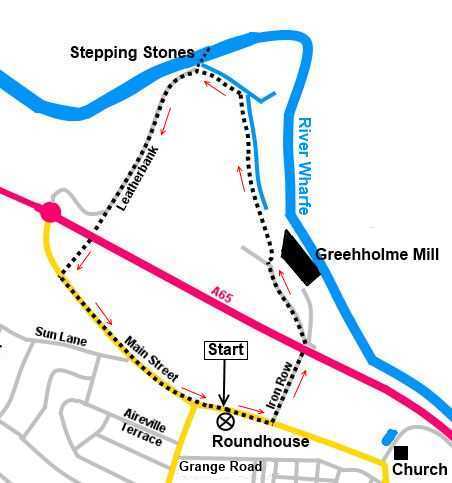
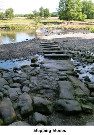
Continue along the broad track until you
reach a junction on the right (SE 166474). Turn right here to view the
impressive stone weir. At this point, stepping stones, which were restored
in 2013, cross to the north bank and when water levels permit, give access
to a large number of walking routes in North Yorkshire. Please do not
attempt to cross unless you are sure it is safe, as there are some deep
pools here. There is a long running campaign by the Burley Bridge
Association to have a bridge constructed here.
%20Weir.jpg)
%20Heron.jpg)
There is a very good chance of seeing herons
on the river here.
Return to the broad track and turn right. The
track becomes a tarmac lane known as Leatherbank. There are pleasant views
eastwards, towards Otley Chevin. Follow Leatherbank until, as it turns right
around the school playing field, you go straight ahead to follow the path
through another underpass under the A65.
%20Leatherbank.jpg)
%20View%20towards%20Otley%20Chevin%20from%20Leatherbank.jpg)
Follow
the path until it emerges into Burley Main Street by a black and white
cottage. Turn left to follow Main Street back to your starting point.
If you need to buy any
hiking equipment/clothing before your trip see the Hiking
Store
All information on this
site is given in good faith and no liability is accepted in respect of any
damage, loss or injury which might result from acting on it.
|


.jpg)
.jpg)
.jpg)