|
Burley-in-Wharfedale
Walk - Bleach Mill and Hag Farm
|
Starting
point and OS Grid reference:

The
Roundhouse, Burley-in-Wharfedale (SE 166464). Car park at rear of Queens
Hall.
|
Ordnance
Survey Map
OS Explorer 297 Lower Wharfedale & Washburn Valley.
Buy this map from
List
of OS Maps
Note: If you use OS Maps on-line, you can download this route via this
link.
| |
Distance: 3.2 miles
| |
Traffic light rating:

(For explanation see My
Walks page)
| |


For advice on .gpx files see
My
Walks page
|

Click
the PDF logo above to give a printable version of this walk without the
photos.
|
To
view route as a dynamic Ordnance Survey map click here.
Introduction:
This walk
takes you via Burley-in-Wharfedale village green and Burley House
(Burley’s only Grade 1 listed building), to Burley House Field. From here,
pleasant footpaths, which feel almost like a secret escape route, guide you
through modern housing and into open country.
Burley House has had various incarnations.
First a private house, then a school, pub, pizzeria and corporate
headquarters. The neighbouring Burley House Field, once part of the
house’s estate still has the remains of a “ha-ha”,’ which, in times
past, would have provided (from the house side) an invisible barrier to
prevent livestock entering the house grounds.
The 8 acre Burley House Field was the subject
of a protracted campaign to have it designated as a Village Greenspace and
Recreational Open Space, starting in 1993. It was finally approved as a
village green in 2009. It has been improved with the addition of new bridges
and stiles and a Burley Community Orchard has been created with apple,
damson, plum and pear trees, planted early in 2014.
After crossing the disused and current
railway lines, the route takes you across fields with good views, to Hag
Farm. It passes within 100 yards of Bleach Mill House. In its grounds are
foundation remains of the old bleach mill, which used to bleach fabrics
woven in the Bradford mills. A perhaps more interesting reason to visit, is
to enjoy a tea and coffee break, accompanied by excellent cakes at the tea
room. The owners Sue and Simon Richmond will show you the foundation remains
and tell you about the history if you ask. The tea room is normally open
during the day.
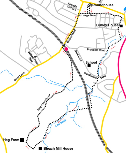
Start:
With your back to the door of the Roundhouse, turn left, walk through the
park to Grange Road and turn left. Pass the Methodist Church.
As the road bends left, at the junction with
Norwood Avenue, go straight ahead on Back Lane. Follow this to the village
green, where there is an attractive view of St Mary’s Church. Note also
the unusual fountain cascading over the large rocks. Turn right, following a
fingerpost for Burley House Field, along Langford Lane
(SE 170462). Follow the lane past Burley House, indicated by the
black and gold topped railings and high stone wall.
%20Burley%20Fountain.jpg)
%20Village%20Green%20and%20St%20Mary's%20Church.jpg)
At the end of the high wall, turn left
through a kissing gate into Burley House Field. Immediately in front of you
are the remains of the stone built “ha-ha”.
%20Burley%20House%20and%20the%20ha-ha.jpg)
Turn right across Burley House Field, heading
for the bridge in the middle. Cross it, over Wood Head Beck, then, turn
right for the diagonally opposite corner of the field. Along here you pass
the Burley Community Orchard.
In the corner of the field, cross the bridge
with the metal gate at the corner of Prospect Road and St Philip’s Way (SE
168458). Turn left to follow the broad path alongside the beck (ignore the
sharp left turn over another bridge, which goes through to Sandholme Drive).
%20Path%20by%20Woodhead%20Beck.jpg)
The path passes allotments. After crossing
another bridge, turn sharp right to follow the beck at the other side. When
you get to the cul-de-sac (Jumb Beck Close), turn right to continue
following the beck.
The path emerges into Sandholme Drive. Go
straight across, to follow the public footpath fingerpost, arriving at a
road - Holme Park. Turn right for a few yards then left down a fenced
footpath, indicated by another fingerpost.
Climb some rough steps to
join the course of a disused railway line. Turn left and almost immediately
right to descend some more steps. Go through a kissing gate then immediately
right through another. (Note the
former route directly across the field via a footbridge is no longer a
public footpath Right of Way).
Follow the path through the
woods to the railway embankment then left through another kissing gate, to
follow the course of the embankment (Note:
the former route which crossed the railway is now closed)
Follow the embankment to a
cattle arch and turn right under the railway, via two kissing gates. Follow
the left hand boundary of the field, ignoring a stile on the left.
%20Railway%20arch.jpg)
%20View%20to%20Burley%20Moor.jpg)
%20View%20towards%20Denton%20Moor.jpg)
At the corner of the field,
go through another kissing gate and again, follow the left hand boundary of
the field, passing the ruins of an old building.
Cross a two plank
footbridge over a stream and follow the left hand boundary and the course of
the stream.
Continuing following the
left hand boundary of subsequent fields until you arrive at the second
squeeze stile, where you exit into a broader track. There is a post with
various yellow footpath arrows (SE 159446).
Bleach Mill House is a hundred yards or so to
the left here, should you be seeking refreshment. Otherwise, turn right.
%20Machinery%20Fpondations%20at%20Bleach%20Mill%20House.jpg)
%20Old%20air%20shaft%20at%20Bleach%20Mill%20House.jpg)
%20Looking%20Over%20Otley%20towards%20Almscliff%20Crag.jpg)
%20Otley%20Chevin.jpg)
Cross a stile close to Hag Farm and turn
right to join the access track to the farm
(SE 158446). Follow the track away from the farm. This becomes the
tarmac Hag Farm Road. At the junction with Moor Lane/Station Road, by the
railway bridge, turn right to return to the village centre and right along
Grange Road to return to the park and your starting point.
If you need to buy any
hiking equipment/clothing before your trip see the Hiking
Store
All information on this
site is given in good faith and no liability is accepted in respect of any
damage, loss or injury which might result from acting on it.
|


.jpg)
.jpg)
.jpg)