|
Bronte
Waterfalls and Top Withens
Starting point and OS Grid reference:

Parking
area on West Lane in Haworth (SE 027373)
|
Ordnance Survey Map
OL21
South Pennines.
Buy this map from
List
of OS Maps
Note: If you use OS Maps on-line, you can download this route via this
link.
| |
Distance: 6.7
miles
|
Date of Walk: 11 October 2013
| |
Ascent:
Descent:
See Walking Time Calculator
|
271m (889ft)
272m (893ft)
| |
Traffic
light rating:

(For explanation see My
Walks page)
| |


For advice on .gpx files see
My Walks page
|

Click
the PDF logo above to give a printable version of this walk without the
photos.
|
To
view route as a dynamic Ordnance Survey map click
here.
Introduction:
This walk from Haworth to Top Withens
(or Withins) is part of the standard tourist fare for the thousands who come
to the Haworth area where the famous Bronte sisters lived and wrote. For
reasons I do not quite understand, the Japanese have taken to English
literature to the extent that so many of them come to this area to follow
the Bronte trail, that fingerposts have Japanese translations!
It is difficult to separate fact from
myth/assumptions. Top Withens, a ruin, may (and I stress may) have been the
inspiration for Wuthering Heights but even the plaque on the wall of the
ruins acknowledges the “may” and stresses that the building bore no
resemblance to the house portrayed in the novel.
The Bronte Bridge which you cross was swept
away in a flood in 1989 then rebuilt so in reality, apart from the moorland
itself and the waterfalls, there are few accredited Bronte associations to
see on this walk. Nevertheless, Brontes or no Brontes, the walk would stand
up as a pleasant, very easy walk in its own right, especially on a pleasant
summer’s day when the heather is out.
Sadly, there was little water flowing down
the falls when I visited.
There are a couple of pubs in Stanbury on
route for refreshments or any number of pubs/cafes in Haworth itself, at the
end.
The walk starts from free roadside parking on
West Lane in Haworth (just before leaving the village on the west side,
towards Stanbury). There is a long parking area but if it is full, there are
free lay-by areas along Cemetery Road, along which the walk goes.
If you want to visit Haworth itself and other
Bronte memorabilia, it is but a short walk back along West Lane. There is
also a large municipal pay and display car park at the junction of West Lane
and North Street but avoid the private car park at the junction of North
Street and Changegate (known as the Changegate car park) as this has a
notorious reputation for merciless implementation of its rules, to the
letter, and has featured in TV consumer programmes.
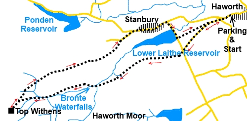
Start:
From the car parking (SE 027373), walk along the road west from Haworth for 300 yards or
so and turn left along Cemetery Road.
%20Lower%20Laithe%20Reservoir.jpg)
Follow this road for just over half a mile
and when it meets another at a ‘T’ junction, go straight ahead on the
rough track (SE 016366), following the fingerpost for “Footpath to Bronte
Waterfalls 1½ miles”.
%20Moorland%20track.jpg)
The track eventually becomes a normal country
footpath and you arrive at the waterfalls by a small footbridge (The Bronte
Bridge) (SD 998358). Cross the bridge and climb
the steps up the bank. You will see a fingerpost at the top ahead of you. On
reaching it, turn left following the fingerpost for “Top Withens 1 mile”.
%20Bronte%20Bridge.jpg)
%20Falls.jpg)
Cross a stream by some roughly laid stepping
stones and beyond this the path is “manicured” with large stone slabs.
When it joins another path with slabs, turn left to follow the finger post
for “Top Withens” and “Pennine Way”.
%20Approaching%20Top%20Withens.jpg)
You soon reach the Top Withens ruins (SD
981354), where there are pieces of stone and rough plank seats, where you
can stay to admire the view/eat sandwiches. Note the stone plaque in the
wall of the ruins, which explains their claim to fame (or not!).
%20Top%20Withens.jpg)
%20Top%20Withens.jpg)
Plaque%20at%20Top%20Withins.jpg)
From Top Withens, retrace your steps and at
the junction with the path where you ascended from the waterfalls but this
time keep straight ahead.
%20View%20from%20near%20Top%20Withens.jpg)
The path divides at a two-way fingerpost.
Keep left signposted “Pennine Way, Stanbury 1 mile and Haworth 2½
miles”.
Stay on this main track, ignoring any turns
off as it descends towards Lower Laithe Reservoir, crossing a cattle grid
and joining a tarmac lane (SE 002366).
%20Approaching%20Stanbury%20and%20Low%20Laithe%20reservoir.jpg)
Pass and ignore a road junction on the left,
then, on reaching a ‘T’ junction at Stanbury, turn right (SE 006370).
Walk through the village and as you leave its
eastern end, turn right at the road junction in the direction of the road
sign for “Oxenhope 2 miles”.
%20Low%20Laithe%20Reservoir.jpg)
Cross the reservoir dam and turn left
immediately after it along a track, following the fingerpost “Bridleway To
Cemetery Road”. This track is initially the access road to the reservoir
works. It branches left to the works and the public footpath is straight on.
When you arrive back at Cemetery Road, turn
left to return to the car.
If you need to buy any
hiking equipment/clothing before your trip see the Hiking
Store
All information on this
site is given in good faith and no liability is accepted in respect of any
damage, loss or injury which might result from acting on it.
|


.jpg)
.jpg)
.jpg)