
|
|
|
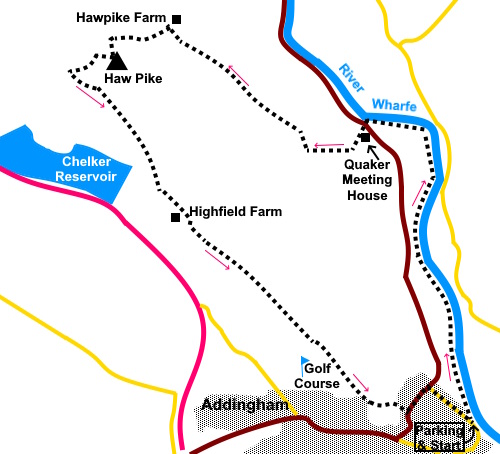
To view route as a dynamic Ordnance Survey map click here. Introduction: Addingham sits in the bottom of the Wharfe valley with Rombald’s Moor stretching up to the south and the Beamsley Beacon ridge to the north. The latter can be accessed via a suspension bridge but although this walk starts from the bridge, we do not cross it but initially follow the Dales Way along the western bank of the river Wharfe. The walk passes Farfield Quaker Meeting House. This was built in 1689 and is very original. It has not been in regular use since the 1950s and is now in the care of the Historic Chapels Trust. It is usually open and you are free to explore. Its interior is very spartan compared to most churches. The walk makes its way to Haw Pike where on a clear day there will be lovely views. Unfortunately my day there could only hint at the promise of what might have been! The last section passes close to Yorkshire Water’s Chelker reservoir, serving Bradford. There are a number of concrete pads which formed the foundations for four wind turbines. These were demolished in 2013. There is a final section through a golf course. The route through is well marked but you need to keep an eye open for golf balls. The walk starts from roadside parking on Bark Lane in Addingham. To get there, turn off the A65 Addingham by-pass (signposted for Addingham, Burnsall and Grassington), on to Main Street. Soon, turn right on to Church Street and follow it as it curves right and becomes North Street. As it bends left, it Becomes Bark Lane and the best place to park is on the right, just after an information board. Start: Descend the path to the suspension bridge but do not cross but turn left to follow the riverside footpath, which is part of the Dales Way.
When the path divides after only three hundred yards or so, keep right. You arrive at a collection of stone buildings where Hamilton’s Café/Bistro sits. Beyond is Olicana Park, a mixture of log cabins and caravans. Keep ahead into the caravan park. A yellow footpath arrow on the gate confirms.
Around half way through the caravan park, take a turn on the right indicated with a ‘Dales Way’ fingerpost (SE 082503), to return to the riverbank.
Continue to follow the riverbank for a mile and a quarter until it meets the road (B6160) at Lobwood House (SE 076519). Here you leave the Dales Way.
Cross straight over the road and through the walkers’ gate. This road can be quite busy so take care. Within a few yards, you will come to Fairfield Quaker Meeting House. Walk round this to join a farm track and turn right. Ignore a turn on the right for Bolton Bridge.
At the farm there is a large stone sigh for Farfield Livery. Keep left here. There is a yellow arrow on the wall. Follow the far track between the horse boxes and between large stone ‘pillars’ across which once passed a railway line. Once beyond these, turn immediately right. Through a gate, bear left following the yellow arrow direction. Head for the left hand end of the trees ahead. Cross a stile here (SE 069520). Once over the stile, continue in a similar line and again heading for the left hand and of a second group of trees ahead (SE 064524). As you reach close to the end of the trees, there is a gate ahead with a stile alongside. Cross and continue in the same line. As you reach the far end of the trees, go through a gate to the right and head towards Hawpike Farm. At the farm, continue straight ahead following the yellow arrow. Do not be tempted to turn left on the broad track, which can seem like a logical direction to return to Addingham.
As you climb the hill, Haw Pike is to the left, although you will not see the white trig. point immediately. It is actually on private land but it is rough pasture and only about a hundred yards from the footpath so I climbed up to see it. Ordinarily, there would be a great view but on this day….! I climbed from SE 060524.
Return to the path and continue on, heading for the right hand end of Berwick East Farm ahead. Go through a walkers’ gate and shortly another (this is to miss out the farm itself) then turn right through another to join another footpath at SE 057522. Four footpaths come together at this farm and is important to make sure you leave by the correct one, which is by turning left along the main drive. You will shortly come to a small wood on the left (Nathan’s Wood according to the sign). According to the map, the footpath runs along its left hand side. This was not particularly clear and I chose to cross the cattle grid and turn immediately left through the gateway after it (SE 058420). Head for the diagonally opposite corner of the field and cross the stile. Follow the wall on the left. At the bottom of the field, cross a rather awkward stone step stile on the left, then turn right to follow the wall. At the bottom of the field is a recessed corner with three gates. Take the one in the far corner and follow the yellow arrow. The path follows the wall and there is a good view of Chelker reservoir.
Go through a gate and ahead is a rather strange ‘hump’, probably covering a pipe. Head for the right hand end of this where there is a stile. Cross this and turn left. At the farm, the path is between the two barns to the left of the farmhouse. The path curves round in front of the farmhouse, where you turn left through a gate, following the yellow arrow. Enter the golf course and as directed by the sign, follow the orange marker posts ahead. The route is straight ahead. Ignore any marker posts off as there is another footpath which crosses the course. Just after leaving the golf course, the path divides. Take the left hand fork. The route is then straightforward. Eventually, you will be parallel with a twin track concrete drive on the left and at the bottom of a field, you join it. Turn right down to Addingham village. At the lane, turn left under the arch. Continue until you meet Bolton Road. Turn left, then right along Bark Lane to return to the start. If you need to buy any hiking equipment/clothing before your trip see the Hiking Store All information on this site is given in good faith and no liability is accepted in respect of any damage, loss or injury which might result from acting on it.
| | |||||||||||||||||

.jpg)
.jpg)
.jpg)
%20Addingham%20suspension%20bridge.jpg)
%20Weir%20at%20Addingham.jpg)
%20View%20back%20to%20Addingham%20and%20Ilkley%20Moors.jpg)
%20Riverside%20Field%20with%20Barn.jpg)
%20River%20Wharfe%20and%20riverside%20path.jpg)
%20River%20Wharfe%20and%20weir%20at%20meeting%20with%20road.jpg)
%20Farfield%20Quaker%20Meeting%20House.jpg)
%20inside%20the%20quaker%20meeting%20house.jpg)
%20View%20near%20Haw%20Pike.jpg)
%20Haw%20Pike%20Trig.%20Point.jpg)
%20Chelker%20Reservoir.jpg)